

ELECTRIC THUNDERSTORMS & TORNADOES 3
ELECTRIC THUNDERSTORMS & TORNADOES 3
The Electromagnetic Nature of Tornadic Supercell Thunderstorms

The Electromagnetic Nature of Tornadic Supercell Thunderstorms - Part 3
Last modified: 2016-08-01 06:45:09 UTC
© 2007~2024 Charles L. Chandler geophysics@charles-chandler.org
Comments, criticisms, and suggestions may be posted on the associated bulletin board.
Contents {Part 3}
The "lightning hole" was mentioned earlier, and an example is clearly visible in Figure 72. While the "hole" is not absolute, and lightning does occur within this region, there is typically a 50~70% reduction in lightning strikes.117,118,119,120 Figure 129 shows the typical time frame in which the reduction occurs.
.gif)
Figure 129. Reduced lightning strike rate before and during the tornadic phase of a storm in Atlanta, GA, 1975-03-24, courtesy Georgia Tech.

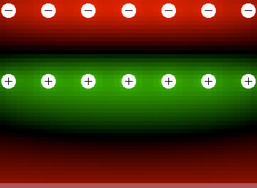
The absence of lightning coincides with the polarity reversal (as mentioned in the previous section). "Normal" thunderstorms and developing supercells typically show a negative charge aloft, with an average field density of 10~15 kV/m. In the polarity reversal, this relaxes to zero and then climbs slightly up the positive scale, stabilizing at 3~5 kV/m. While the inversion persists, the field density stays low, and there is a distinct reduction in the lightning rate.
In the standard model this makes sense, as the cloud base is thought to switch to a weak positive charge during the tornadic phase, when the weak field supports less CG lightning. But the EMHD model maintains that the cloud is negatively charged the whole time, while during the tornadic phase, a positive double-layer shields the negative charge in the cloud from instrumentation near the ground. The main field is then between matched positive and negative charges aloft. (See Figure 73.) Still, the positive double-layer is closer to the ground, so the Earth gets an induced negative charge, and near the ground we measure an "inverted" field, where the charge aloft is positive. The field is weak, but that's just because we're only measuring the field between the outside of a shielding layer and the adjacent solid conductor (i.e., the Earth). The voltage in the main field (between the cloud and the air just below it) might actually go up (perhaps way up).
This then begs the question of why the "main field" doesn't produce even more lightning. It would be CC instead of CG, but the voltage should be higher, and the distance less, so the flash rate should go up, not down.
It's possible that the discrepancy is coming from the fact that electric fields and lightning rates are not actually directly related, and it's easily possible for the electric field to be well beyond the normal threshold for lightning, without discharges occurring. In the laboratory, at standard temperature and pressure, it takes 3,000 kV/m to get an arc discharge in the air. So this is a physical limit that cannot be surpassed, and which is known as the breakdown voltage of the air. Interestingly, lightning becomes probable in fields over 20 kV/m, and virtually certain in fields over 30 kV/m. So meteorological literature talks about 30 kV/m as if it's the breakdown voltage, when really it's only 1⁄100 of the required field. So how is lightning even possible at 30 kV/m?
The answer is that lightning is not a simple, instantaneous arc discharge — it's a complex process. It starts with a flash inside the cloud less than 100 m long, where the potential has exceeded the breakdown voltage of the air. Then, in a process that sometimes lasts several seconds, the lightning channel elongates. Each stepped leader occurs in a local field in excess of the breakdown voltage, but this process can continue until distant regions with a resting potential far below the breakdown voltage can eventually become connected by a discharge channel. So the electric field meter might be showing only 30 kV/m, but a couple of microseconds before it gets struck by lightning, the field jumps up to 3,000 kV/m, and no physical principles have been violated.
The significance of this is that without the initial flash, the whole process never would have been initiated, and we should theoretically be able to see close to 3,000 kV/m of potential without there being any lightning.
Then the critical question becomes: what causes the initial flash? The quick answer is that nobody knows for sure. It shouldn't be possible to develop the charge densities necessary for an arc discharge, when the charges are held by the air itself, as electrostatic repulsion should prevent them. But we do know that lightning occurs in a turbulent environment. Some of the lay literature states that colliding parcels in a turbulent flow generate static electricity that sets off the lightning strike. It's probably more accurate to think that turbulence simply brings oppositely charged parcels closer together far more rapidly than we'd see in a laminar flow, and this is what increases the local field density beyond the breakdown voltage.
Now if we consider the context in which tornadoes occur, we see large, very well-organized laminar flows, in the mesocyclone and in the positive-double layer. As such, these parcels might lack the lightning triggering mechanism, and might therefore be capable of up to 3,000 kV/m of potential before hitting the absolute limit. In fact (as we'll see in the section entitled "Corona Discharges"), corona discharges are occurring outside of the vortex. At the standard temperature and pressure outside of the tornado, corona discharges require 100 kV/m of potential — well above the typical 30 kV/m in which lightning occurs, while being 1⁄30 the requirement for an arc discharge. So we know that the "normal" threshold for lightning is being surpassed in tornadic storms, without there being any lightning. We also know that after the tornadic phase, the lightning rate jumps way up, even though the storm is weakening, and therefore, is manufacturing less charge separation. This only makes sense if the electrostatic potentials were building up the whole time, but couldn't get discharged during the tornadic phase due to the lack of a triggering mechanism. So the spike in the lightning rate after the tornadic phase is the discharge of the potential that built up during the tornadic phase.
And there is a significance here that is far broader than just accounting for a lightning hole in the presence of increased electric charges. In the section entitled "Strategies," the following statement was made.
The EM forces need not be powerful, even by thermodynamic standards. [...] In a supercell, weak EM forces resolve into a structure, and the sum of the effects of the weak forces produces a new property set.
Now we can see how this can happen. A large laminar mesocyclonic structure enables a great deal more charge to be stored inside the storm than would be possible otherwise. Then distinctive EM phenomena are observed.28,29,30,31,32 It's possible that the large laminar structure, the massive amounts of electric charge, and the distinctive discharges are all parts of a fully coupled EMHD system. The charge delays the transition to turbulence, which then reduces the amount of potential that gets discharged in lightning, which allows greater charge densities in larger, more organized structures. Then a new property set emerges, including a mesocyclonic recirculation, with a negative core and a positive double-layer, and with the capability of instantiating a tornadic flow field.
In other words, we knew before we began that we were looking for a rare combination of factors that somehow produced behaviors that shouldn't be physically possible. The positive feedback loop identified in the present work is just that kind of combination, and the expected properties of the weak but well-organized EMHD structure match the observations.
Tornadic storms produce sustained RF emissions in the range of 20~140 MHz.17,198,199,200 Also, there appears to be some sort of causal relationship between higher frequency emissions and extremely powerful tornadoes.
One source of sustained RF emissions could be small-scale arc discharges at the top of the cloud, where the charge separation process begins.201 But discharges at the top of the cloud would have no obvious causal relationship with the tornado at the bottom of the cloud. Another theory is that the waves are generated by rotating charges in the tornado.202 But no explanation is given for how a vortex rotating at less than 60 rpm would generate waves at 20~140 MHz.
Given that the specified relationship is between tornadoes and RF emissions, the most logical place to look for the source of the emissions is inside the tornado. We know that there is an electric current inside the tornado, sufficient in rare cases to create glow discharges, and in extremely rare cases, arc discharges at the tornado/mesocyclone interface, visible from the outside. The fact that the distinctive RF emissions are far more consistent than the observations of tornadic lightning indicates that the discharges are normally hidden inside the cloud.
The frequency of RF emissions from lightning is a function of the distance traversed by the moving electric charges. While there is an ongoing surge of charged particles flowing in one direction, the surrounding electric and magnetic fields are being modulated. When the flow stops, the fields revert to their resting state. If there is a return stroke, the polarity of the fields reverses. The result is waves whose period is a function of the duration of the surge, which is a function of the distance that is traversed. Assuming that the speed of the electrons in lightning is 1⁄10 the speed of light,203 or roughly 30,000,000 m/s, we can develop rough numbers for the length of the lightning channel, given the frequency of the RF emissions. For example:
speed = 30,000,000 m/s
frequency = 30 kHz = 30,000 cycles / second = 1 cycle per 1/30,000 s
distance = 30,000,000 m/s × 1/30,000 s = 1,000 m
Please note that the distances being described here are not the wavelengths. The field modulations occur over a period of time defined by the distance of the particle traversal, while the waves propagate at the speed of light. As an analogy, a wire might move back and forth in a magnetic field once per second, traversing a total of 1 m. This will produce an electric current having a frequency of 1 cycle per second. The electric current flows at near the speed of light, with a wavelength equal to the distance that light can travel in a second (300,000,000 m). So the distance traveled by the prime mover, and the wavelengths produced, are totally different.
The following table shows a representative sampling of frequencies, and the distances traversed to generate them.
Table 3. RF Emissions

Since most lightning traverses 1~3 km, most of the RF energy is in the VLF band (3~30 kHz),111,204 with enough energy present in the AM band (520~1610 kHz) to cause radio static. The RF interference created by tornadoes in the TV band (54~216 MHz) is of sufficient amplitude, if the tornado is within a couple of kilometers, to overpower the TV signal, resulting in a screenful of snow.205 The discharge channels associated with such interference would be less than 0.56 m long, and it's possible that these correspond to the reports of "lightning fingers" inside the tornado.161,162,163
Note that the high-frequency emissions are only detectable with a TV set if the tornado is within a couple of kilometers. It doesn't take very many watts of power to transmit RF energy that distance.
While the distinctive high-frequency emissions do not precede the tornado, so they cannot be used to predict tornadoes, they might be useful in verifying tornadoes. 77% of all tornado warnings are false alarms, so not everybody takes aggressive defensive action when they hear the sirens. But a confirmed tornado on the ground is a different issue. Unfortunately, there isn't always someone there to make such a confirmation. But radio waves can be detected from a long distance (with instruments more sensitive than a TV set), so real-time monitoring of these emissions could lead to more reliable nowcasting.
There have been many reports of the smell of ozone in the area around a tornado. Since high-voltage electric equipment (such as arc welding) produces ozone, people have frequently characterized the smell as "electrical," and this was one of the "clues" that led researchers to believe that lightning at the tornado/mesocyclone interface was the driving force in tornadoes.
It's actually a bit odd that they did not fully consider the implications of this line of reasoning. Because the air under a mesocyclone is converging toward it, if ozone is present and it's coming from the tornado/mesocyclone interface, it certainly did not travel against the converging winds to get to the people on the ground. It had to rise through the updraft, and then get pulled all of the way back to the ground (as the FFD) in order to be smelled at the ground level. Figuring out how this ionized oxygen could get pulled back down to the ground would have led them to consider 40 years ago the ideas being presented now in this paper. Regardless, the researchers contended that tornadic lightning had to be present in order to get an updraft powerful enough to produce a tornado, and when that was proved false, the whole EM paradigm was tossed.
The source of the ozone could, indeed, be tornadic lightning, but it could also be simply a product of the ionization that is occurring in the charge separation process at the top of the cloud, magnified by particle sorting en route to the tornado. So positive charges in the RFD and FFD will increase the amount of ozone, and as the ions will be more attracted to the Earth than neutral particles, people on the ground will sense the chemical difference.
And while the EMHD model does not place any central significance on tornadic lightning, it does rely heavily on ionization as a necessary condition for tornadogenesis. So the presence of ozone at the ground is not just an artifact of tornadic lightning, or of the charge separation process. It is an index of the degree of ionization in the air, and the EMHD model asserts a causal relationship between that and the probability of tornadogenesis.
Tornadoes also create a variety of distinctive sounds.131,206 The "freight train" sound is commonly reported, which is also likened to the roar of a jet engine at full throttle. The standard explanation is that the violent turbulence in the air creates random sonic events that combine into a continuous roar. But this doesn't explain why the roar of an EF3 tornado is distinctly different from the howl of a Category Five hurricane, both with the same wind speeds.
The following is a report from directly under a mesocyclone as the funnel cloud was just forming (later to touch down 20 km away).207
As the sound of thunder would approach from the distance, the "growl" of thunder would sound like it was being trapped in the vortex overhead producing a sound very similar to what an old steam train sounds like when it pulls out of the station — whooomf, whooomf, whooomf... and fade away after several seconds, until the next roll of thunder came along then another whooomf, whooomf, whooomf... overhead.
The most plausible explanation for thunder "growling" repetitively, instead of booming just once, is that the thunder was interacting with the low pressure inside the mesocyclone. Since the speed of sound in air varies with temperature, and since the low pressure inside the mesocyclone reduces the temperature, sound will travel through the mesocyclone slower than around it. This will create a "clap" on the other side, which will then reverberate back through the mesocyclone. If this effect lasts several seconds, and if there are several lightning strikes per second, and other sonic events due to turbulence in the air and object-object collisions at the ground, the reverberations will merge into a continuous roar. So it would be the low pressure inside the tornado and/or mesocyclone that would be responsible for this distinctive roaring sound, not just random sonic events.
Then there is another sound that is reported and that is quite different, and which seems to be associated with just the funnel cloud, though it is only heard before the funnel cloud touches down. This has been characterized as a hissing, whistling, whining, humming, or buzzing sound. The following is a description of the sound made by a funnel cloud in Dodge City, KS, on 1928-06-22.208
At last the great shaggy end of the funnel hung directly overhead... There was a screaming, hissing sound coming directly from the end of the funnel... Around the rim of the great vortex (about 50~100 ft. diameter) small tornadoes were constantly forming and breaking away... It was these that made the hissing sound.
This higher-frequency sound is thought to be the same as the low frequency sound generated by the mature tornado, though while the funnel cloud is still in the air, the sound of smaller sub-vortexes is not overpowered by the roar of the main vortex on the ground.209 But again, the howl of high winds is well-known, and can be reproduced in the laboratory easily, while the distinctive hissing or buzzing sound has never been reproduced just with high winds.
People who have heard this sound, and who also have worked around high-voltage electric equipment, always equate the sound with that of a sustained discharge through the air. Those who have witnessed St. Elmo's Fire (a corona discharge) report the same hissing sound. If there is an electric current flowing through the tornado and into the inflow, and if the bottom of the funnel cloud is where negative and positive charges are meeting, it will certainly produce precisely this kind of sound.
St. Elmo's Fire is a corona discharge that produces a blue or violet light when it occurs in the presence of nitrogen and/or oxygen. It emanates from pointed objects in an electric field exceeding 100 kV/m.160 It is most commonly observed at the end of a thunderstorm, and sailors named it after St. Elmo (their patron saint), believing that he had once again delivered them from the perils of a storm at sea. The same blue/violet halos can be seen around lightning, and around electrical equipment generating sufficient voltages. (See Figures 130~132.)
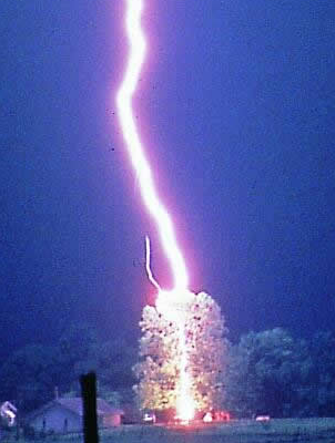
Figure 130. Lightning. Notice the small violet corona discharge. Courtesy Johnny Autery

Figure 131. Corona discharge from a tesla coil, courtesy Robert Hunt.
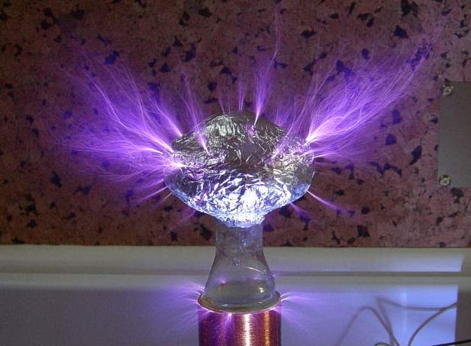
Figure 132. Sustained sub-station fault with a surrounding violet corona discharge in Corvallis, OR, 2005-10-30, photo courtesy Stonebridge Engineering.

Corona discharges in the atmosphere are a rare occurrence, and are a bit difficult to explain, since they seem to require more electrostatic potential than lightning. If the contentions in the section entitled "Lightning Holes" are correct, corona discharges are definitely possible. 100 kV/m for a corona discharge is well below the 3,000 kV/m necessary for an arc discharge, and fields greater than 150 kV/m have been measured many times in the absence of lightning.210 But we'll only see corona discharges when turbulence is not initiating lightning strikes. This will most likely occur at the end of a thunderstorm, when charged downdrafts are undercutting the updraft, and electrostatic potentials are still present, but the vigorous airflows are subsiding.
A brilliant series of such discharges was captured on video recently, a couple of hours after a line of severe thunderstorms passed through Ft. Worth, TX. It's possible that charged downdrafts were clinging to the conductivity of the Trinity River, and where the river intersected high-voltage power lines between Beach Street and Handley Ederville Road, the towers provided the pointed objects necessary to trigger discharges. The blue flash in Figure 133 is an electron avalanche in ionized nitrogen and oxygen. The orange in Figure 134 is a more vigorous discharge in highly ionized oxygen. The violet in Figure 134 is neutrally charged air. As the chemical composition of the air certainly wasn't changing from one flash to the next, the different colors were an indication of the voltages present, with violet requiring the least, and orange the most.
Figure 133. Corona discharge in Fort Worth, TX, 2011-05-10, courtesy Brian Luenser.

Figure 134. Corona discharge in Fort Worth, TX, 2011-05-10, courtesy Brian Luenser.

Figure 135. Corona discharge in Fort Worth, TX, 2011-05-10, courtesy Brian Luenser.

Interestingly, corona discharges have been observed under supercells, outside of the tornadoes (if present) while the storms were still quite active.31 NASA scientists stationed in Huntsville gave detailed reports of the numerous colors associated with the storm pictured in Figures 136 and 137, while only blue and orange flashes were actually photographed.211 Some of the reports were from plasma physicists, who explicitly identified the elements and ionization levels on the basis of the colors. Such discharges prove that supercells are doing something to prevent the lightning initiation process, allowing electrostatic potentials to far exceed the normal threshold for lightning.
Figure 136. A luminous discharge outside a tornado captured on video (at 9 frames/sec) in Huntsville, AL, 1974-04-03, courtesy Otha H. Vaughan.

Figure 137. Two photographs of the luminosity (taken about 31 seconds apart) from a tornado in Huntsville, AL, 1974-04-03, courtesy W. M. Dobbs.

Here's another more recent example, also from Huntsville.
Figure 138. Blue flash as EF2 tornado was forming in Huntsville, AL, 2010-01-21, courtesy printfac.

Blue and orange flashes were captured by a security camera in Millbury, OH. There were 4 blue and 2 orange flashes just in a 6-second period. In Figure 139, the right side of the tornado itself is silhouetted by the orange flash.
Figure 139. Orange and blue flashes around tornado that did EF4 damage in Millbury, OH, 2010-06-05, courtesy DRACONi Security Agency.

Even more recently, sustained orange flashes were captured by a security camera in Chattanooga, TN, immediately after a tornado. The flashes were thought to be fires started by the tornado. But the flashes in the video emanate from lightpoles, which have no fuel to sustain fires of such intensity. And despite the high wind speeds, the flashes maintain a (more or less) vertical form, instead of being blown in the direction of the winds as we would expect. Furthermore, the lights were not damaged by the "fires."
Figure 140. Orange flashes following tornado in Chattanooga, TN, 2010-10-28, courtesy U.S. Army Corps of Engineers.

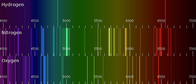
Flashes originating from point-sources on the ground are typically attributed to transformers blowing up when power lines short-circuit. But this doesn't explain the blue and orange colors. When a transformer blows up, the arc discharge is bright enough to saturate some or all of the affected frames. Outside of the whited-out areas, there is little to no corona. If there is a corona, it is violet. (See Figures 130~132.) The presence of large coronas, and their color, constitute direct evidence of highly ionized air, one of the central tenets of the EMHD model. Blue could either be ionized nitrogen or oxygen. Orange can only be ionized oxygen. (See Figure 56 for the emission spectra.)
.jpg)
Cloud-base striations sometimes appear under the mesocyclone, and are known by their nearly circular form, with nearly horizontal, semi-continuous features. The form suggests lines of motion, but the actual rotation is slight.
Figure 141. Wall cloud and cloud-base striations in Ravenna, NE, 2002-07-24, courtesy Gregg Hutchison.

Figure 142. Wall cloud and cloud-base striations in Canton, OH, 2007-08-09, courtesy Weather Underground.

Figure 143. Cloud-base striations in Childress, TX, credit Carsten Peter, courtesy National Geographic.

The standard explanation is that these are simple extensions of the rotation within the mesocyclone. In other words, the mesocyclone is rotating, so other stuff around it will start rotating too. There is also a rotation in the surface inflow (even if a tornado has not formed), that might help "spin up" the striations from the inside.
It's important to note that the circular form clearly reveals that this air is not flowing into the mesocyclone — otherwise we'd see a spiral pattern. And if the air was simply "spun up" by exterior and/or interior rotation, there would have to be a perfect balance between the low pressure inside (to create a centripetal force) and the centrifugal force of the rotation. Then, the low pressure, distributed by the opposing centripetal and centrifugal forces, would encourage condensation.
While such an explanation is possible, the EMHD model suggests another explanation that is equally possible. It also might be that a combination of factors contributes to this form.
A steady charge stream from the cloud toward the ground will generate a magnetic field (i.e., Ampère's Law). This magnetic field will not induce any rotation in the surrounding air. But since water molecules are diamagnetic, they will get oriented according to the magnetic field.212 Interestingly, molecular orientation is a necessary step in the condensation process. Hence it's possible that the limits of the condensation that make up the cloud-base striations are evidence of water vapor that is almost ready to condense, and that gets a little help from a magnetic field.
The condensation process then explains the conversion to a turbulent flow above the striations in Figure 143. Condensation releases latent heat, which causes an updraft. This updraft has nothing to do with the surface inflow, or with whatever is going on inside the mesocyclone. It is merely an artifact of condensation within the striations themselves.
.jpg)
It also makes sense that the cloud-base striations have a flat bottom. By Helmholtz's laws, we know that all vortexes have to either close on themselves, terminate at a solid boundary, or taper to a point.213 But the sharp upward turn of the inflow means that all of a sudden, all of the magnetic lines of force resolve into a unified field surrounding the surface inflow. And this is precisely the point at which the water molecules begin condensing.
It's also possible that the shelf clouds that appear encircling the main rain area are a related phenomena, though the moving charges responsible would be simply the rain itself. (See Scott Blair's shelf cloud page for more examples.)
Figure 144. Shelf cloud in Enschede, The Netherlands, 2004-07-17, courtesy John Kerstholt.

One aspect of supercells that has never been addressed by any EM theory is the development of mammatus clouds. While these forms are of little general interest to meteorologists, because they occur late in the cycle of a thunderstorm (and therefore offer no predictive value), and because they don't pose any risk, they are nevertheless distinctive phenomena that deserve explanation.
Mammatus clouds are rounded forms that appear under the anvil of a severe thunderstorm as it dissipates. (For more mammatus photography, see Jorn Olsen's "cloudscapes" page, or this page on the Environmental Graffiti site.) The lobes tend toward consistency in size, and while sometimes the arrangement is nearly random, sometimes the lobes occur in linear patterns. The individual lobes last about 10 minutes before evaporating, but a formation of them can sometimes persist for a couple of hours.214
See the Wikipedia article for a good description of the leading theories on mammatus cloud formation, and for the reasons why they are considered adequate.
Figure 145. Mammatus clouds, courtesy Cassio Leandro Barbosa.
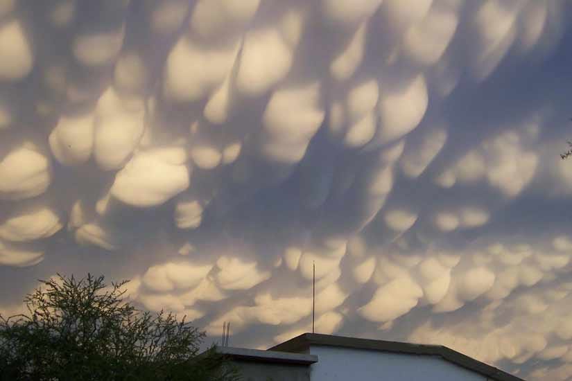
Figure 146. Mammatus clouds, courtesy Cassio Leandro Barbosa.

Figure 147. Mammatus clouds over Kansas, 2008-06-12, courtesy 3D King.

To understand what causes mammatus clouds, we should first consider the context in which they occur. In the late stage of a thunderstorm, the updraft has expired, and downdrafts dominate. At this point, the airflow in the anvil switches direction, from its outward expansion driven by the updraft, to inward contraction toward the void left by the downdrafts at the top of the cloud.
In this context, we can understand the linear organization of the mammatus clouds. While the updraft was still forcing air into the anvil, the flow was turbulent, and long, straight cloud features were not possible. But when the airflow reverses direction, and downdrafts are pulling the anvil back toward the center of the storm, the airflow is laminar, and in this condition, linear structures can emerge.
The next question is: what is responsible for getting the laminar flow to resolve into distinct bands? The quick answer is that nobody knows, but the EMHD model suggests a possibility. We know that the anvil is storing an enormous amount of positive charge, and we know that charged gases have a lower viscosity. So while electrostatic repulsion tends to disperse the charges, in motion the more highly charged parcels flow faster. So we can expect streams of charged particles flowing through neutral surroundings. The two forces together then result in a series of equally spaced bands. Electrostatic repulsion limits the amount of charge in each band, and distributes the bands evenly, while the reduction in viscosity organizes the flows.
Then the question is: what is causing the water vapor to condense? Here, again, the quick answer is that nobody knows. The reduction in pressure in the anvil also reduces the temperature, and this encourages condensation. But condensation isn't going to cause a falling parcel of air that would become a mammatus lobe — condensation causes updrafts, due to the release of latent heat. And though the lobes look like drops of water on a ceiling that are ready to fall, such is not their nature. Rather, the lobes simply dissolve after 10~15 minutes.
And here again the EMHD model offers a suggestion. In the reduced pressure after the airflow in the anvil switches direction, we would otherwise expect more condensation in the anvil. But we also know that the anvil is positively charged. So electrostatic repulsion will prevent the aggregation of water molecules. We also know that there is a powerful electric field between the positively charged anvil and an induced negative charge in the Earth. This could pull the more highly charged parcels downward, and there could also be a flow of electrons upward in this field. As depicted in Figure 148, the lines of electric force will approach a positively charged falling parcel from every direction. Electrons entering the parcel will neutralize the positive charge. Without any electrostatic repulsion, if the air is below the dew point, the water vapor will condense. And the form of this condensation will be spherical. In other words, the lobes are the anodes in an electric field between the ground and the cloud, and the visible aspect of the lobes reveals the arrival of electrons.
Figure 148. Positive charges (green) over a conductor with an induced negative charge (red). The white lines represent the highest field density. Electrostatics applet by Paul Falstad.

So the possibility is that an electric current flowing upward from the ground enables condensation, especially in the parcels that have the most charge. The condensation process then releases latent heat, and the parcel is sent upward, leaving the hemispherical form at the bottom to simply dissolve.
Now we can look back at the images of this phenomenon, and resolve the remaining anomaly. Intuitively, we would expect the anvil to be opaque with condensation, with the mammatus lobes just being the side of the anvil that is facing us on the ground. But in the images, we can clearly see that there is no condensation above. The condensation is, in fact, a very thin boundary condition. Above the boundary, the air is super-saturated with water vapor that cannot condense because of its charge. At the boundary, electrons from below enable condensation, which falls out of the anvil and evaporates again in the drier air below the anvil. And the parcel that released the condensation is sent back up into the clear air above.
In the extreme poverty of data on the conditions within mammatus clouds, there is little to constrain the speculation, and the contentions in this section are purely conjectural. Nevertheless, the photographic evidence constitutes a challenge for any theoretical candidate, and it's appropriate to demonstrate that the EMHD model can at least suggest an explanation that's possible, while the standard model cannot.
"Waterspout" is an ambiguous term in meteorology, but most commonly, it refers to a vortex that was formed by a non-mesocyclonic thunderstorm over water, and the term "landspout" refers to a similar vortex over land. These are sometimes called "fair weather" vortexes, but that's a bit of a misnomer — they still require the presence of a thunderstorm. 'Spouts account for 20% of the vortexes that are reported as tornadoes.54
Some researchers consider 'spouts not to be tornadoes at all, but rather, some other type of vortex, and not even worth studying. It is certainly true that mesocyclonic storms are responsible for almost all of the EF2+ tornadoes. Because of that important causal relationship, the standard probabilistic model is built around the mesocyclone, leaving no place to put data collected from 'spouts. But a detailed analysis of the physics that causes these vortexes doesn't have the same problem, and the flow fields in non-mesocyclonic vortexes are definitely tornadic.215 The inflow hugs the surface of the Earth from over 1 km away, in spite of the skin friction, and the lowest pressure is at the surface, as far as it can get from the source source of the low pressure inside the storm. 'Spouts tend toward the "stovepipe" form, and typically have a dust sheath (or aerosol sheath over the water). But these characteristics can be present in mesocyclonic tornadoes as well. So the EMHD model considers these vortexes to be of the same type as tornadoes, and they require the same explanation. And they are definitely worth studying. Mechanistically speaking, in no sense can a rotating updraft 1 km above the surface be responsible for tornadic wind speeds at the surface. If we are to fully understand tornadoes (including those that do descend from mesocyclones), we have to understand the actual forces responsible for them, and non-mesocyclonic vortexes better isolate those forces. We can then investigate how mesocyclones, in addition to their incidental rotation, also develop larger quantities of such forces. From an operational forecasting perspective, we might still place a great deal of emphasis on the mesocyclone. But we might also gain the ability to predict non-mesocyclonic tornadoes, which are responsible for 2⁄3 of the unwarned events, and to overlook the mesocyclones lacking the forces necessary for tornadoes, which are responsible for 9⁄10 of the false alarms.33,54 Without this factoring exercise, such improvements in forecasting will not be possible.
The section entitled "A New Hypothesis" proposed that the essential ingredients for a tornado are a solid conductor at the bottom, positively charged inflow, and an electric current inside the vortex. Conspicuously absent is the necessity of an updraft in the cloud, much less a rotating one. The sense in which an updraft aloft is significant (especially if it's rotating) is that the lower pressure (especially in the core of a vortex) also lowers the electrical resistance, opening up a conduit for the flow of electrons, and thereby initiating the tornadic process. But it wouldn't necessarily have to be a thunderstorm updraft or a mesocyclonic vortex. Any random gust at a downdraft outflow boundary might create a small vortex that might open up a conduit for an electric current, and then the tornadic feedback loop might take hold.
This suggests that tornadoes should occur all of the time. So what is the rare factor? That would be the presence of warm, positively charged air at the ground (which is typical at the end of the thunderstorm), while there is still a lot of negative charge in the cloud, especially if there is still a powerful updraft. In other words, a long-lived thunderstorm is more likely to spawn a tornado. In a normal thunderstorm, the downdrafts undercut and extinguish the updraft. So at the end of the cycle, there might be a strong positive charge near the ground, but at that point, the bulk of the negatively charged precipitation has already fallen out of the cloud, and there is no updraft (much less a rotating one) to serve as a conduit for an electric current. So only those storm structures that are capable of sustaining the updraft and the downdrafts, and of keeping the negative charges suspended in recirculation patterns, long enough for all of the pieces to come into play, will be capable of spawning tornadoes.
The mesocyclonic storm structure has already been described in detail. Another structure capable of spawning tornadoes is the cylindrical airflow in a squall line.216 Like any thunderstorm, a squall line manufactures precipitation inside the updraft. At the top of the cloud, gravity and terminal velocity sort out the particles, with heavier precipitation falling first, and therefore taking the inside track, while the positively charged ice crystals are trapped in the air from which they condensed. Once the charges have been separated, it's possible that the electric force establishes a positive double-layer enveloping the negative inner core. This would get positively charged air down to the surface, where it could stick to the surface and set the stage for a bottleneck discharge vortex.
Figure 149. Possible EM structure of a vortex-producing squall line.

Figure 150. Line of waterspouts off the coast of Albania, 1999-08-01, courtesy Roberto Giudici.

Note that the tornadoes that sometimes occur behind squall lines are more typically supercellular. Behind the line, warm inflow to the squall is topped by cool air displaced by the anvil, and this sets up the wind shear and convective potential that could result in a cumulonimbus cloud that could become mesocyclonic.
In the case of a tornado associated with an isolated thunderstorm that is not part of a squall line, and that is not mesocyclonic, it's possible that the recirculation is simply toroidal (without the mesocyclonic twist), as depicted in Figure 1.
In cases where extremely robust mesocyclones develop, but that do not produce tornadoes, the EMHD model contends that there may have been a well-developed negative charge stream inside the storm, but there was not enough charge in the positive double-layer to support a tornado.
Dust devils are definitely different from tornadoes, as they occur completely outside the context of thunderstorms, and in fact require that there be little to no cloud cover at all. So there is no electric current flowing down through the vortex, and there is no release of latent heat due to condensation in the vortex wall. (In Figure 151, the vortex is white just because that's the color of the dust on the ground.) And in the absence of a thunderstorm, the charge separation mechanism is very different. But like a tornado, the fuel source is a shallow layer of hot, low-viscosity, charged air clinging to the ground because of the electric force. And like the debris cloud in a tornado, the charged air in a dust devil gets neutralized by lofted dust, releasing the air from its attraction to the ground, and thereby enabling the updraft. Dust devils are not of interest to meteorologists, as these extremely weak vortexes almost never cause fatalities. But they do have a few things in common with tornadoes, and studying dust devils allows us to see some of the same forces operating in a very different environment.
Figure 151. Dust devil in Saltillo, Coahuila, Mexico, 2008-03-10, courtesy Dupondt. Click here to watch the associated video.

On a cool, sunny day, the Sun heats the surface of the Earth, and the heat radiates into the air. Normally hot air rises, but in the conditions that form dust devils, the hot air defies its buoyancy and clings to the ground instead. (The temperature gradient can be so great that mirages become possible, where light waves are refracted by the difference in density between the hot air and the cooler air just above it.) So how can hot, buoyant air cling to the ground, topped by cooler, denser air, without convection distributing the heat?
The only possible explanation for hot air not rising is that another force is present, and the only other force present in the atmosphere is electromagnetism. Since air is not responsive to the magnetic force, the only possibility is that it's the electric force. We therefore know that an electrostatic attraction pulls the air down to the Earth, and with more force than the buoyancy that pushes it up. For this to be true, there has to be a charge separation process, resulting in the air and the Earth being oppositely charged. Then the question is: what is separating the charges?
It is well known that photons can ionize molecules. So when photons impact the soil, some of the electrons are excited to an energy level that liberates them from the molecules. Of those, the ones heading upward will then get captured by air molecules, developing a negative space charge in the air. Then there will be an attractive force between the negatively charged air and the positively charged ground.
Ordinarily, we would think that the conductivity of the Earth should preclude ionization. The only electrons that will be liberated will be from the topmost molecules, and these should be easily replenished from the vast electron cloud of the Earth. But if the surface of the Earth is getting ionized, it solves another riddle. Dust devils are most likely to occur over poorly-conductive soils, such as sand in a desert. In the present context, it's easy to understand why. Poor conductivity is a necessary condition if there is to be a charge separation due to ionization — otherwise, missing electrons in the soil will be quickly replaced from the underlying molecules, and any net charge that might develop in the air will be dispersed by electrostatic repulsion. So a charge separation between the air and the Earth is possible under these conditions. And if the electric force offsets the buoyancy of the hot air, enough thermal energy can accumulate to power a dust devil.
Considering the fact that the electric force is 39 orders of magnitude more powerful than gravity (which is the fundamental force responsible for cool, dense air falling and for hot air, with less density, rising), we would then wonder why an updraft would ever become possible at all. The electrostatic potential should prevent the hot air from rising, until the Sun goes down and the ionization process stops, at which time the opposite charges will recombine faster than they are getting created.
Yet there is a limit to how strongly ionized the surface of the Earth can become. Incoming EM waves can liberate weakly-bound electrons from molecules directly exposed to the sunlight, but once a net ionization has developed across the surface of the Earth, the electric force will prevent the escape of electrons into the air. This limits the amount of space charge that can develop. Yet the temperature of the air can continue to increase. If the buoyancy of the hot air overpowers its electrostatic attraction to the ground, a small parcel of air will break away, ascending to an altitude appropriate for its low density. As the electric force falls off with the square of the distance, the rising parcel will experience less downward force the higher it goes.
The vacuum created at the surface by the first rising parcel will be filled by air sliding along the ground, still bound by the electric force, yet responding horizontally to the low pressure. Once the lateral inflow achieves the point at which the first parcel rose, the low pressure aloft, combined with the parcel's buoyancy, overpowers the electric force, allowing the convergent inflow to rise as well. So the first rising parcel triggers a continuous flow of air along the ground and then upward at the point of convergence.
Since the hot air layer is so shallow, we might think that the updraft will quickly run out of thermal energy in its immediate vicinity. If cool air from above is drawn in, the updraft will fail. But charged air has a lower viscosity, because electrostatic repulsion prevents the particle collisions that instantiate friction.25,26,27 So the ionized air will flow more easily than the cool, neutrally charged air above it. Hence the vacuum near the ground will be filled with more hot air, even if the hot air has to travel a greater distance than cool air from above. This creates the possibility of hot air from a broad area flowing along the ground to get into a single, organized updraft.
If the updraft is stationary, its intensity and duration are limited by the distance from which hot air can be drawn, with its friction still being lower than the friction of drawing in higher-viscosity air from above. If the terrain is flat and smooth, we can expect the effective inflow to come from further away, as skin friction will result in boundary vortexes that will be relatively small, and turbulence will not reach the full depth of the hot air layer. Hence the laminar flow in the hot air layer will present little friction. Rougher surface conditions will reduce the effective inflow radius of the updraft.
If the updraft can get more hot air from one direction than from another, it will move in that direction, and instead of the air moving to the updraft, the updraft will move to the air that can rise. This removes the restriction on the duration of the updraft. Regardless, the intensity of the updraft is still limited by the rate at which it can pull air from the hot air layer without pulling in cool air from above.
If the converging lines of motion are not perfectly radial, a spiraling inflow pattern will emerge, and the updraft will become a vortex. The direction of the rotation is random, and it is common for both cyclonic and anti-cyclonic dust devils to occur in the same area, with the same conditions. It is also possible for the same dust devil to switch directions and continue on. This is true in both the northern and southern hemispheres of the Earth. Hence there is no reason to believe that the rotation is being encouraged by the Coriolis effect, or by Lorentz force acceleration, both of which would prefer one direction over another, and which would be hemisphere-specific.
If the air moves fast enough, it will start to kick up dust at the surface. The dust has the charge of the Earth. When mixed with the oppositely charged air, the net charge of the hot air becomes zero, completely freeing the air from its electrostatic attraction to the Earth. Hence the dusty air will rise far more vigorously than the clear air that initiated the process. This explains the rapid intensification in the instant that the dust devil becomes visible due to airborne particulate matter.
The corollary also appears to be true, that while the presence of dust might help free the space charge from its attraction to the ground, the space charge might be responsible for hoisting far more dust into the atmosphere than would be predicted simply on the basis of wind speeds and durations.217,218
The charge separation mechanism (ionization from sunlight), combined with the consolidated convection, accounts for the huge voltages detected in dust devils. The 10 kV/m potentials that have been measured are typically attributed to triboelectric charging from particle collisions within the vortex, but this doesn't explain why there would be any triboelectric charging at all when particles of similar constitution collide, nor why there would be that many collisions anyway in the laminar inflow to a vortex, nor why other vortexes of similar intensity (such as gustnadoes) do not develop similar potentials.
It is not likely that the reduced pressure inside the vortex (which will lower the electrical resistance of the air) will result in any significant "fair weather current" in the presence of the fair weather electric field (100 V/m), as some have contended. It is also not likely that at the distances and speeds in question, there is any significant increase in temperature due to skin friction.
As concerns dust devils on Mars, the question is not so much a matter of how a temperature inversion occurred, with a layer of hot CO2 under cool CO2, and where the total buoyancy, if all consolidated into a vortex, could create a dust devil. Rather, the first and biggest question is how that much work could be performed at all in an atmosphere that is so thin. This can be answered with the same mechanism. A charge separation, instantiating an electric field, could create a space charge in which the atmospheric pressure is far greater than normal. Then, if surface heating increases the buoyancy beyond that which can be contained by the electric force, an updraft occurs. In these conditions, there is no cooler layer above the hot layer, so the intensity of the dust devil is not limited to how fast it can pull in hot CO2 without pulling in cool CO2 from above as well, extinguishing itself in the process. Hence dust devils of great size and speed become possible.
Positing the existence of a major charge separation that gets neutralized by the mixing of charged CO2 with oppositely charge dust also explains the flashes that have been observed at the base of Martian dust devils. Heat from the discharges might also contribute to the buoyancy of the updraft, though there's no reason to suspect that this is a necessary condition.
Figure 152. Dust devil on Mars, taken by rover Spirit on sol 486, courtesy NASA.

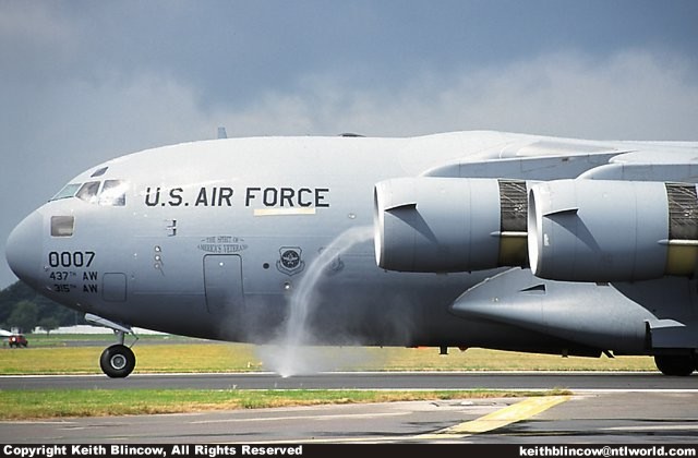
A curious cross between a tornado and a dust devil is pictured in Figures 153~155. These vortexes are tornadic in two significant respects: 1) the vortexes expand in the direction of the flow, and 2) there are "debris funnels" originating from the mouth of the vortexes. In previous sections, both of these behaviors were shown to defy the principles of fluid dynamics.
Figure 153. Suction vortex between a jet engine and the ground, courtesy Derek Ferguson.

Figure 154. Inlet vortex, courtesy Boeing.

Figure 155. Inlet vortex, courtesy Keith Blincow.

Figure 159 shows a CFD simulation, which succeeded in getting vortexes in the inflow, but (of course) could not reproduce the expansion in the direction of the flow, nor the debris funnels, which fluid dynamics does not allow. These characteristics are displayed consistently in tornadoes, indicating the presence of another force, which can only be electromagnetism.
Figure 156. CFD simulation of inlet vortices, courtesy Drs. Yoram Yadlin and Arvin Shmilovich of the Boeing Company.

Because the vortex expands in the direction of the flow, we know that there is a bottleneck with an extreme low pressure at the ground. Only an electric force between the air and the ground could create such a bottleneck in the flow. Outside of the context of a thunderstorm, we have no reason to suspect that the air could have a strong positive charge. And since asphalt is an insulator,219 the ground wouldn't support much of an induced charge anyway. So we can suspect that the charging mechanism is photo-ionization on the surface of an insulator, as it is in dust devils, and that the air is negatively charged, having absorbed the electrons liberated from the asphalt. Once an electric field between the air and the ground is instantiated, the air can be heated above its thermodynamic equilibrium without rising, because the electric force offsets the buoyancy. In other words, there is a temperature inversion, with hotter air at the surface that refuses to rise, topped by cooler air just above it that cannot fall. (This explains why asphalt is famous for producing mirages.)
Now we just need a charge neutralization mechanism, to release the air from its attraction to the ground, enabling ascension into the vortex.
Here we can definitely rule out neutralization by lofted dust/debris. Runways used by jets have to be kept perfectly clean, as anything lofted into the engines will destroy them. And there cannot be any telluric currents through the poorly conducting asphalt. So the neutralization can only occur as a result of an electric current through the vortex, as it would in a tornado. But unlike a tornado, the electrons must flow upward through the vortex, as the charge that needs to be neutralized is negative. The electromotive force would be an attraction to the positively charged jet engine exhaust, with the low pressure in the vortex serving as the low-resistance conduit.
Once neutralized, the moist air clinging to the tarmac is free to condense, and the vortex becomes visible. Premature neutralization even supports a "debris funnel" that seems to be outflow from the mouth of the vortex, but as in a tornado, is just powerfully buoyant air that has been released from its electrostatic attraction to the ground before it gets into the vortex, and rises out of the inflow. From there, the "debris funnel" seems to be only weakly affected by the low pressure at the mouth of the engine, as the aspect of it that is forward of the engine does get sucked in, but some of it appears to stagnate aft of the intake, and to the sides of it. This is analogous to the fast flow in a tornado, within the larger context of air moving slowly into a mesocyclone. Needless to say, the inboard engine is not at full throttle, or the "debris funnel" would be drawn straight into the engine, and the outboard engine might be idling.
So this vortex has the lower boundary and polarity of a dust devil, but with a secondary low pressure "aloft" that a dust devil does not have, and with a neutralizing current flowing through the vortex, producing a distinctly tornadic form. Of all of the photography and videography that was reviewed in the preparation of this paper, this is the only vortex that can truly be called tornadic that was not produced by a thunderstorm. All of the other so-called "tornado simulators" shown in the section entitled "Lab Suction Vortexes" are simple suction vortexes that contract with proximity to the source of the low pressure, and are incapable of developing "debris funnels" in split flow fields.
On May 25, 1955, a supercell spawned two F5 tornadoes, one that damaged Blackwell, OK, and the other that destroyed Udall, KS. This storm displayed extremely robust EM properties, and because of this, a number of EM theories of tornadogenesis emerged. Unfortunately, in the 1950s so little was known about tornadoes that there was nothing to constrain the speculation, and the theoretical work yielded little lasting value.
With far more information, and with a theoretical framework that can now explain a wide variety of tornadic properties, we can revisit the first-hand observations made by a trained weather observer on that day, to see if the theory in question can explain even the most extreme of cases.
Figure 157. Diagram of Blackwell-Udall tornado, 1955-05-25, courtesy Floyd Montgomery.
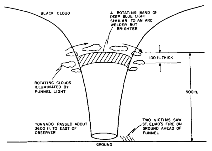
The following properties in the diagram are explained by the EMHD model:
the expansion of the vortex in the direction of the flow, without pulling in any air above the surface (as proved by the persistent scud clouds near the top of the tornado, that should have been drawn in rapidly if there was any upper-level inflow),
the fact that the condensation funnel was baseless (the air had too much positive charge to condense),
the presence of St. Elmo's Fire (there was a strong positive charge above the surface), and
the blue light being emitted at the tornado/mesocyclone interface (the positive charge was getting neutralized by a flow of electrons down from the cloud).
In addition to what is show in the diagram, other reports include:
an "electrical" smell (ozone, evidence of ionization), and
difficulty breathing (high-pressure air with a strong positive charge).
In other words, the EMHD model explains all of the anomalous aspects of the phenomenon.
It's instructive to note the results of electric field measurements made on the same storm, and the characteristic interpretation of those results at the time.116
At the time of the passage of the funnel near [within 5 km of] one observing station, the surface electric field fluctuations became relatively quite small and the electric field density approximated 0.4 kV/m. There is little evidence suggesting that the electrical effects near the funnel differ basically from normal thunderstorm electrification.
Small electric field fluctuations, and extremely low electric field densities, actually differ radically from normal thunderstorm electrification. And St. Elmo's Fire occurring in an electric field measuring 0.4 kV/m is not physically possible. (The pressure would have to be so low that there wouldn't be enough molecules present to create the observed luminescence.) The dismissal of the data was simply the researcher's reaction to that which he could not explain. The inexplicable lack of electric field would later become known as the "lightning hole," and remains inexplicable to this day outside the context of the EMHD model. And the glow discharge that was observed had to be the result of a concentration of electric charge near the vortex.
Having considered a wide variety of phenomena produced by supercell thunderstorms, we must also remember that all of these properties are caused by a finite number of forces. Therefore, the various forms are products of differences in the balances of forces present, and it would be useful to attempt to classify the distinctive forms on the basis of the strengths of the forces. Then the hypothesis in question can be further challenged by comparing the asserted balance of forces with the in situ data.
Table 4. Balance of Forces Responsible for Different Properties

Green Thunderstorm
negatively charged precipitation loses electrons to the positively charged air under the cloud, resulting in photon emissions
should only be possible in an inverted polarity storm, where there is a positive charge "aloft" (as measured from the ground) with the main negative charge region above it

Beaver's Tail
inverted temperature/humidity gradient — warm, dry air nearer the ground, topped by cool, moist air
requires inverted polarity storm
lots of negative charge in mesocyclone flowing through tube

Cloud-base Striations
large amount of charge flowing down from cloud, into air and opposite charge in ground
high-humidity air
insufficient angular momentum to generate vortex

Funnel or Stovepipe
strong positive charge in air clinging to ground
moderate electron flow down from cloud
moderate inflow to mesocyclone

Vortex Breakdown Above Ground
more extreme energy release at surface resulting in higher swirl ratio
weak inflow to mesocyclone
Vortex Breakdown at Ground
even stronger positive charge in air clinging to ground, resulting in even higher swirl ratio
weak inflow to mesocyclone

Shrouded in Turbulence
even stronger positive charge in air clinging to ground, resulting in even higher swirl ratio
weak inflow to mesocyclone

Wedge
extremely strong positive charge in air clinging to ground
massive negative charge in cloud flowing toward ground
extremely robust inflow to mesocyclone

Baseless Vortex
high conductivity in Earth and/or strong positive charge in air
powerful updraft
Condensation Only at Surface
weak positive charge and/or low conductivity in Earth
only occurs in the seconds before the vortex falls apart
Now we should begin to consider the actual prospects for EMHD within the meteorological community. NSSL states that "as far as scientists understand, tornadoes are formed and sustained by a purely thermodynamic process." That's actually an understatement. They could have added, "and we don't see that changing." The following quote is from a relatively recent paper co-authored by the director of NWS's Storm Prediction Center.220 The authors recount wild stories from the tornadic lore, many of which are a bit incredulous, but they only discredit the accounts of unusual EM phenomena. They further contend that such phenomena are only to be found in the lore, and are not to be taken seriously.
As our knowledge of tornadoes has increased, so has the quality of our observation. Many early accounts of tornadoes are filled with what today we would consider curious, or even false, observations of "electric" or "fiery" tornadoes. These strange accounts led many noted researchers to speculate that tornadoes were inherently electrical phenomena.
Indeed, for many years, the noted meteorologist Bernard Vonnegut was one of the leading advocates of a link between tornadoes and electricity. For instance, he described a 1965 Ohio tornado as having a "beautiful electric blue light" and a "ball of orange lightning [that] came from the cone point of the tornado." A classic description by weather observer Floyd Montgomery of a "luminous" tornado in 1955 appeared in the June 1956 issue of Weatherwise. "As the storm was directly east of me, the fire up near the top of the funnel looked like a child's Fourth of July pin wheel.... As near as I can explain, I would say it was the same color as an electric arc welder but much brighter, and it seemed to be turning to the right like a beacon lamp on a lighthouse."
Even earlier accounts attempted to link tornadoes and electricity using damage assessment. Nineteenth-century meteorologist Robert Hare, for example, claimed that the "parched and scorched" nature of the vegetation following a 1835 New Jersey tornado conclusively proved that electricity is fundamental to tornado formation.
However, with the advent of cameras, video-cameras, lightning-detection equipment, and other sophisticated meteorological instruments over the last 50 years, we now find that tornadoes do not demonstrate marked electrical activity. Research into the "electrical nature" of tornadoes has faded away. The question that must be asked (but unfortunately can't be answered) is, why did all those early accounts mention "luminous" tornadoes? Did they see something that we don't see today? Or was it self-fulfilling prophecy — people expected to see fiery tornadoes, and so they did?
The authors knew that tornadic luminosity has been captured with cameras and video-cameras, as some of the evidence is in the one of the papers that they quote (unless they didn't look at the pictures).157 They should have known that lightning-detection equipment has detected marked changes in electrical activity during the tornadic phase of thunderstorms, as one of the Storm Prediction Center's initiatives is to predict tornadoes on the basis of lightning patterns (unless the Director didn't expect to see that in the budget, and so he didn't).117,118,119,120,221 They also should have known that "other sophisticated meteorological instruments" have detected powerful magnetic fields30,112,113,114 and telluric currents.112,180 So why did they dismiss the instrumented data? Then the authors attempted to discredit the eyewitnesses. Are we really to believe that the dozens of NASA scientists who observed the tornado in Huntsville, AL in 1974211 all wrote false reports, because they "expected to see a fiery tornado"? And did their film expect to be exposed to a fiery tornado?
The question that really must be asked is why did all those modern authorities ignore the instrumented data and the credible eyewitnesses?
To understand the official stance against electric tornado theory, we have to see it in the context of the history of tornado research. The modern scientific study of tornadoes began with a classical thermodynamic approach in the 1950s. By the end of that decade, scientists already knew that tornadoes were not simple suction vortexes. Through the 1960s, a number of EM hypotheses were considered. But after 20 years of research, it became clear to everybody that they just weren't making any progress. So in the early 1970s, the physics funding got cut, and a new strategy emerged. If the objective is to predict tornadoes, then by the time they spin up, it's already too late. So we actually need to forget about why tornadoes behave precisely as they do, and instead, we should be looking at the preconditions that result in tornadoes. This means focusing just on the original source of the energy in thunderstorms, which takes us above the storm scale, and into the study of air mass collisions, wind shear, etc. (Note that above the storm scale, electromagnetism is not a big factor, so this shift in granularity took it out of the picture.) And due to the poverty of data at that scale, and the processor-intensive nature of the Navier-Stokes equations, operational weather forecasting is not mechanistic physics — it's probabilistics. Take the data collected by the weather balloons, interpolate between the collection points to estimate temperatures, pressures, wind vectors, etc., throughout the area of interest, and then look for recognizable patterns in the way everything is moving that will yield predictive value. If possible, quantify the causal relationships, such that whenever the preconditions are present, a numeric probability of the outcome can be generated.
Not having actually worked out the physics of tornadoes, in the mid-1970s meteorologists filled the void with a probabilistic model (as described in the section entitled "Thermodynamic Supercells?"). Because of the causal relationship between mesocyclones and tornadoes (especially the most powerful ones), the model simply extends the mesocyclonic rotation down to the ground to make a tornado. Even though it defies physics, this at least provides the framework for associating preconditions and outcomes, enabling numerically derived tornado forecasts with accuracy well above chance.
As concerns the evidence of unusual EM activity in tornadic storms, the only way that researchers can defend their funding is to deny that they're missing something, and to discredit those who attempt to call their attention to the oversight. In this context, it's not surprising to hear a ranking government official stating that "tornadoes do not demonstrate marked electrical activity," in spite of the evidence. The funding for electric tornado theory was cut in the early 1970s. If they can't get funding for probabilistic modeling, they can't get any funding at all. So the best thing for society is to suppress the evidence that tornadoes are electromagnetic. It was tough at first, but the passage of 40 years has made it easier. Now they can say that unusual EM activity in tornadic storms is only to be found in the historical literature from more than 40 years ago. It's axiomatic that modern instruments don't detect such things, because there isn't any modern funding. Anybody who doesn't know this can be led to believe that the historical reports are simply not up to modern standards.
So now, thunderstorms are purely thermodynamic. For example, in 2009~2010 meteorologists spent $12 million on VORTEX2, the most ambitious tornado field study in history. The following is an impressive overview of the instrumentation that was deployed.
VORTEX2 used an unprecedented fleet of cutting edge instruments to literally surround tornadoes and the supercell thunderstorms that form them. An armada of 10 mobile radars, including the Doppler On Wheels (DOW) from the Center for Severe Weather Research (CSWR), SMART-Radars from the University of Oklahoma, the NOXP radar from the National Severe Storms Laboratory (NSSL), radars from the University of Massachusetts, the Office of Naval Research, and Texas Tech University (TTU), 12 mobile mesonet instrumented vehicles from NSSL and CSWR, 38 deployable instruments including Sticknets (TTU), Tornado-Pods (CSWR), 4 disdrometers from the University of Colorado (CU), weather balloon launching vans (NSSL, NCAR and SUNY-Oswego), unmanned aircraft (CU), damage survey teams (CSWR, Lyndon State College, NCAR), and photogrammetry teams (Lyndon State University, CSWR and NCAR), and other instruments were deployed.
In all of that, there wasn't one single electric field meter or magnetometer. No study of a thunderstorm would be complete without at least one measurement of the degree of electrification — unless of course the storm spawns a tornado, in which case the structure and dynamics of the system become purely thermodynamic?
Unfortunately, neglecting key data guaranteed that meteorologists would hit the wall before crossing the finish line, and such is now the case. Only 1⁄4 of all mesocyclones produce tornadoes,54 and even with in situ data, supercells that produce tornadoes are difficult to distinguish from those that do not.33 Furthermore, some of the most powerful mesocyclones on record did not produce tornadoes,98,99 while 20% of all tornadoes descend from thunderstorms that aren't rotating.54 Since meteorologists only look for mesocyclones when assessing the risk of tornadoes, the non-tornadic mesocyclones generate false alarms, and the non-mesocyclonic tornadoes strike without warning. With the existing model, those statistics will never improve.
So how are we to proceed?
To a physicist, this would be easy to answer. No CFD or laboratory simulation using realistic conditions has ever produced a tornadic vortex, and with good reason — the principles of thermodynamics preclude it. In a rigorous discipline, this would constitute proof of the presence of another force. In the atmosphere, that other force can only be electromagnetism. In the 1960s, electromagnetism alone was shown to be inadequate for tornadogenesis. There is only one other possibility — tornadoes result from a combination of electromagnetic and thermodynamic factors. Some exploration in this direction has been done in the last 40 years, such as the work that Vonnegut and others did with discharge vortexes.108,109,110,222,223 Progress has been slow, due to a lack of funding, and because of the novelty of the approach. But in recent years, EMHD has come a long way, and now has a broad body of generalized principles that are being applied to a wide range of problems.70 Some scientists are becoming of the opinion that all of the natural mysteries that have not already surrendered to either Newtonian or Maxwellian physics will, by definition, one day surrender only to a combination of Newtonian and Maxwellian physics. So the enigmatic nature of tornadoes is precisely the type of problem that calls for such an interdisciplinary approach.
But meteorology isn't a rigorous discipline. The paradigm shift in the early 1970s, from mechanistics to probabilistics, didn't just de-emphasize physics. It changed the way meteorologists think about physics. "Thermodynamics" has become a very loose, flexible framework that can be adapted easily to explain just about anything, and in no sense is it constrained to physical laws.
If that sounded incredulous, consider the following abstract from a recent work published in a prestigious journal that extends the meteorological model of mesocyclones to explain volcanic plumes.224
A strong volcanic plume consists of a vertical column of hot gases and dust topped with a horizontal 'umbrella'. The column rises, buoyed by entrained and heated ambient air, reaches the neutral-buoyancy level, then spreads radially to form the umbrella. In classical models of strong volcanic plumes, the plume is assumed to remain always axisymmetric and non-rotating.
Here we show that the updraught of the rising column induces a hydrodynamic effect not addressed to date — a 'volcanic mesocyclone'. This volcanic mesocyclone sets the entire plume rotating about its axis, as confirmed by an unprecedented analysis of satellite images from the 1991 eruption of Mount Pinatubo. Destabilized by the rotation, the umbrella loses axial symmetry and becomes lobate in plan view, in accord with satellite records of recent eruptions on Mounts Pinatubo, Manam, Reventador, Okmok, Chaitén and Ruang. The volcanic mesocyclone spawns waterspouts or dust devils, as seen in numerous eruptions, and groups the electric charges about the plume to form the 'lightning sheath' that was so prominent in the recent eruption of Mount Chaitén. The concept of a volcanic mesocyclone provides a unified explanation for a disparate set of poorly understood phenomena in strong volcanic plumes.
In mechanistic terms, all of the statements in their second paragraph are false.
Of all of the volcanoes studied (Pinatubo, Manam, Reventador, Okmok, Chaitén and Ruang), only the satellite imagery from Pinatubo actually showed any rotation in the umbrella — the others did not. As there isn't any way for an umbrella to rotate fast enough to become unstable without the rotation being apparent in the satellite imagery, the contention that umbrella rotation is an intrinsic property of volcanic plumes is false.
That leaves open the question of what caused the rotation at Pinatubo. The authors contended that it was boundary vortex tilting and stretching.
Figure 158. Induction of rotation in a volcanic mesocyclone, courtesy P. Chakraborty, G. Gioia, and S. W. Kieffer.

In reality, two small, counter-rotating vortexes do not combine into one big vortex — they cancel each other out — so that doesn't explain anything. The actual reason for the rotation at Pinatubo is that in an unprecedented coincidence of catastrophes, the umbrella absorbed the impact of Typhoon Yunya, which then relaxed from a tropical cyclone to a tropical storm.225,226 As the angular momentum of a typhoon is real, there is no need to invoke artificial contrivances like vortex tilting and stretching.
Figure 159. The umbrella above Mount Pinatubo (marked with a yellow X), 1991-06-15, 08:40 UTC, courtesy USGS. The approximate position of Yunya at the time of the image is marked with a red cross.

Furthermore, a mesocyclone does not "group the electric charges about the [updraft] to form a 'lightning sheath'." In fact, it does the exact opposite — it forms the core of the lightning hole. The lightning in a supercell is primarily in the downdrafts (which volcanoes do not have) around the outside of the storm. The charge separation in a volcanic column actually begins with triboelectric charging inside the subterranean vents, and lightning is possible even at the mouth of the vents.227 So explaining volcanic column electrification with a mesocyclone metaphor is just not correct.
Lastly, to think that the slow rotation of an umbrella in the stratosphere is somehow connected to the fast rotation in a tornado at the surface of the Earth, when the tornado is separated from the umbrella by over 10 km of non-rotating air, is just not possible. Indeed, the plume in Figures 160 and 161, which is too weak to create an umbrella, and which is not rotating, nevertheless displays strong electrification and two tornadoes. It's clear that in volcanoes, and in thunderstorms, tornadoes can be correlated directly to the electric force, and not to updraft rotation.
Figure 160. Volcano with two waterspouts nearby at Kilauea, HI, July 2008, courtesy Center for the Study of Volcanoes.

Figure 161. Lightning inside volcanic plume at Kilauea, HI, July 2008, courtesy Center for the Study of Volcanoes.

Still, the authors were confident that they had achieved a "unified explanation for a disparate set of poorly understood phenomena"? Actually, they merely achieved a careless dismissal of a few bothersome anomalies, and this was sufficient scholarship in atmospheric thermodynamics to get published in a prestigious journal.
This is the type of discipline that one day will determine with rigorous logic that another force must be present in tornadogenesis? First we'll have to teach meteorologists how to do rigorous logic. Then, if they stop suppressing evidence, they might realize that their model cannot be improved, and that tornadoes actually result from a combination of electromagnetic and thermodynamic forces. Then there will be progress.
And there might be a lot of progress. The following is a list of the previous sections that described possibilities already queued by the EMHD approach.
A mechanistic model of the evolution of mesocyclones could support tornado warnings much further in advance (especially for EF2+ tornadoes, which are the most important to predict, and which are almost always the products of mesocyclonic storms).
A better understanding of hail production mechanisms could lead to more reliable hail warnings, and further in advance.
Tornado track predictions based on the vertical extent and EM organization of the storm, combined with the direction of the upper-level jet stream, might be more accurate than predictions made by existing methods.
The color of the outside of the cloud could be used (at least by people there to observe it) as an indirect measure of the degree of electrification, and thereby, the probability of tornadogenesis.
Atmospheric Vortexes, Tornadic Levitation, and Exploding Houses
Currently, assessments of the forces acting on buildings during tornadoes make unrealistic assumptions about the nature of the flow fields. Laboratory tests instantiating realistic flow fields could lead to advances in the way we engineer buildings to withstand the actual forces.
The structure of the back-sheared anvil, and the density of virga falling out of it, might be closely tied to tornadogenesis, and operational emphasis on these factors could lead to more accurate tornado warnings.
It might be possible to confirm that a tornado has touched down, and possibly even estimate its force, on the basis of electric currents in the ground.
The presence of a tornado can be verified by its radio-frequency emissions.
A study of non-mesocyclonic vortexes could help isolate the essential ingredients in tornadoes, leading to a reduction in the number of unwarned events, and in the number of false alarms.
The next two sections explore a few more possibilities of a more immediate and practical nature.
77% of all tornado warnings are false alarms, while 27% of all tornadoes occur without warning. And in none of the cases do we have the ability to predict the strength of the tornado that might form. Obviously, we're missing something. The rotation of the mesocyclone is definitely a factor.228,229,230,231 But if it takes a positive double-layer to turn a normal suction vortex into a bottleneck vortex, and if we're not even looking at any EM factors in assessing the risk of tornadoes, we will never have more than loose causal relationships. If we actually start looking at the active ingredients for tornadogenesis, we could see a major improvement in our predictive capabilities, and that could save lives.
Measuring electric charges from a distance is not possible, because charged double-layers build up, and there is no electric field outside of the double-layers. But moving electric charges generate magnetic fields, and these can be detected from a distance, because there is nothing to shield them. In fact, the magnetic field generated by a tornado was measured at 1.5 × 10⁻⁴ gauss from a distance of 9.6 km away using a magnetometer.112 There is currently no construct within the mainstream research community that assigns any significance to these data. Nevertheless, and with or without a construct that can explain it, if there is a strong causal relationship between the strength of the magnetic field and the incidence of tornadogenesis, we should be looking at these data along with the thermodynamic factors when assessing the tornadic risks.
Figure 162. Data from an array of magnetometers, combined with Doppler radar data, might help pinpoint the location of a tornadic supercell.
And there are two different types of value that might be awaiting us if we pursue this. First, magnetometers might be able to detect the magnetic field being generated by the storm, where the stronger the field, the more organized the storm, and therefore the greater the probability of tornadogenesis. Second, the tornado itself appears to generate a distinctive field that is greater than the field from the storm itself. Detecting this field wouldn't help up predict the tornado, but it would help us confirm that there is, in fact, a tornado on the ground, and might also help us estimate the strength of the tornado. This sounds trivial, but it is not. A tornado warning is one thing, but a confirmed report of a tornado on the ground is something altogether different, and is far more useful information to people in harm's way. This is especially true if confirmation is not possible any other way (if the tornado is rain-wrapped, or if it occurs at night).
The typical response to this proposal is that we already have an adequate strategy for the study of tornadoes, and that there is no need to be looking outside of the existing framework. Approximately $15 million per year are spent in the U.S. on tornado research (including the efforts of NWS, a variety of educational institutions, and some private research facilities funded by NSF). This yields slow but steady progress in our understanding of tornadic storms. All of this research is focused on the thermodynamic context in which these storms occur, and on unrealistic numeric modeling of the dynamics of the storms. And $15 million seems to be about the right amount of money to spend, considering that tornadoes only kill 89 people per year.
But all of that is predicated on the assumption that research into the electromagnetic nature of tornadic storms would be more expensive. Yet this research might actually be far cheaper. High-precision, highly-directional magnetometers only cost a couple hundred dollars, and since they are hand-held units, they could easily be deployed experimentally as well as operationally. Scientists could use magnetometers to help locate tornadic storms to gather more data in the field. Considering the cost of field studies, adding a couple of $500 magnetometers to increase the number of successful of intercepts would make a lot of sense. And fixed installations could be used to help develop more accurate tornado warnings, along with instrumental confirmation of tornadoes in progress. Every town big enough to have a fire house and a police station should have a couple of magnetometers around the outskirts of town, feeding data to a central server that will issue alerts if critical magnetic field densities are detected.
In the U.S. every year, tornadoes on average destroy $982 million worth of property,1,2 and kill 89 people.3 This is not good. And it's just a matter of time before a tornado destroys a major U.S. city. It would be just too shameful if such a thing was allowed to happen, when it could have been prevented.
There have been suggestions, and even some funded research, concerning ways of preventing tornadoes assuming that they are purely thermodynamic. One proposal is to disrupt the storm using microwave energy beamed down from a satellite.12,13,14,15,16,17 Unfortunately, there is no way to realistically evaluate the effects of such a strategy, since no realistic thermodynamic model of supercells exists. (Looking at the effects of an introduced heat source within a creative mathematics model would be just playing with numbers.) And such a strategy would be prohibitively expensive to implement just to see how it would work.
The EMHD model suggests that other forces are at work in supercells, and this leads to the consideration of different strategies for tornado prevention. If a powerful positive charge in the RFD is one of the essential ingredients in a tornado, and if that charge could be neutralized, the tornado would dissipate. The mesocyclone would continue to run at full speed, but the inflow would not get stuck to the ground, resulting in the release of energy at the ground that is a tornado. And it's at least theoretically possible that triggering lightning strikes in the RFD would neutralize enough of the charge to weaken or destroy the tornado.
Several different strategies for triggering lightning have been developed; the results pictured below are from a rocket with a wire attached to it.232,233 The straight line reveals the location of the triggering wire. The jagged lines are subsequent strokes of discharge after the triggering wire was vaporized. Another strategy uses a rocket that leaves a trail of conducting chemicals in its path.234 Yet another strategy involves using lasers to heat up the air, which increases its conductivity.235
Figure 163. Triggered lightning, courtesy University of Florida.

Figure 164. Triggered lightning, courtesy University of Florida.

Figure 165. Lightning rockets, courtesy Chris Kridler.

Figure 166. Possible tornado mitigation strategy.

While it's theoretically possible that this would work, and while it would certainly be worth testing just for the theoretical significance, it wouldn't seem to have any practical value. There can be dozens (or even hundreds) of tornadoes in one day, and having dozens (or hundreds) of teams in the field to deploy lightning rockets would not be economically feasible. Throw in the fact that tornadoes are just plain tough to catch, and it's hard to imagine how "tornado fighting" would ever be cost effective.
But there is a way that tornado fighting could be approached that would be far more practical. Of the 1,000 tornadoes that occur every year in the U.S., only 10 hit populated areas, and if we focus on protecting just the populated areas, we have a much smaller problem to solve. And instead of chasing the unpredictable bastards, we should just wait for the tornadoes to come to us, and only fight them if they threaten populated areas. In other words, considering the number of tornadoes that occur every year, and their unpredictability, and considering the cost of fielding that many full-time teams to fight them, a "man-on-man defense" is not the way to go. Rather, "goal tending" would be a more effective use of resources, since we're only concerned about a very small portion of the field. If every major city had trained tornado fighters who could respond on short notice to the threat of an approaching supercell, the chance of successful intercepts goes way up. And instead of maintaining full-time teams, we should simply call out the tornado fighters when they are needed.
This is not the way we study tornadoes, because the chance of a tornado coming to us is so slight. Any given city that is 20 km across, including suburbs, is going to get hit by some tornado once every 50 years. This is too infrequent to be useful for research purposes, so we increase our chance of an intercept by chasing the storms. But if we stop thinking about research, and start thinking about tornado prevention, the infrequency becomes a practical advantage. It means that tornado fighters will not have to deploy very often. If a city is to be hit by some tornado once every 50 years, then once every 15 years, a supercell that could have spawned a tornado will pass over the city, and perhaps 10 times a year, a thunderstorm that could have become a supercell will pass overhead. If 10 times a year tornado fighters go out and fire lightning rockets into the RFDs, the city will be protected from the threat.
Finding people qualified to fire the rockets will not be hard. Rocketry is a hobby, and there are thousands of people in the U.S. who have the certification necessary to fire rockets of this type, just for the fun of it. The National Association of Rocketry currently has 108 local chapters throughout the country. So that's 108 cities that have enough rocketry enthusiasts to form a local club. These people simply need to be trained to intercept thunderstorms. And certainly anyone who likes firing rockets is going to love firing lightning rockets. So finding candidates for the couple of days of classroom training, and a week or so of field training, will not be hard.
So let's see what it would cost to do this.
Table 5. Costs per Deployment
Table 6. Costs per City per Year
At $50,000 per year, the 50-year cost comes out to $2.5 million. Since the 50-year event typically costs at least $10 million, that's a 4-to-1 return on investment, or an average yearly net savings of $150,000 per city. And that is practical. And in addition to saving money, we'd also be saving lives.
Since the aspect of the storm that needs to be attacked is the RFD, and which can be approached from the NW without having to get inside it, the tornado fighters would not have to get in harm's way to deploy the rockets. The major safety concern would be the risk to aviation in the vicinity.
For research purposes, we can go out in the middle of nowhere, and test the technique on tornado-warned, actively tornadic supercell thunderstorms. We can rest assured that there are no airplanes in these clouds, since no airplane can survive the hostile conditions within such storms (50 m/s downdrafts, grapefruit-sized hail, etc.).
But the practical application of this technology would be a different scenario. To protect a city from a tornado, the tornado fighters would obviously be much closer to a city. This means that they would be close to a major airport. Additionally, they wouldn't always be firing into actively tornadic supercells. If they deploy 10 times a year, and if a supercell only passes overhead once every 15 years, then 149⁄150 of the deployments will be into normal cumulonimbus clouds. And there very definitely could be airplanes within these clouds.
Therefore, if tornado prevention is to become a practical reality, air traffic controllers will have a significant role to play. Once a meteorologist identifies a threatening thunderstorm, and calls out the tornado fighters, the local air traffic controllers will have less than 10 minutes to clear the thunderstorm of airplanes, or to call off the tornado fighters if they cannot.
It will be easy to get the buy-in of the Federal Aviation Administration (FAA), since a tornado hitting a major airport is FAA's worst nightmare. Planes fly nicely in the high wind speeds of a tornadic storm, but without the expertise of a pilot, they land poorly. So FAA should be as interested as anybody in seeing this initiative succeed.
Figure 167. Tornado near Stapleton International Airport, Denver, CO, 1988-06-15, credit Richard Filhart, courtesy NCAR.
Figure 168. Planes that have landed poorly after flying in a tornado, courtesy Tinker AFB History Office.

And certainly, asking air traffic controllers about the location of planes in the vicinity of an airport will not exactly be an unusual question. It's just that they have never been asked this specific question before. Being able to answer this question with absolute certainty might take new hardware, and/or new software, and/or a new protocol. FAA will have to estimate the cost of its part of this initiative, and that will then be added into the cost-benefit analysis.
This has been, and will continue to be, a massively speculative work. The key data to make or break the central tenets have not been collected, because the hypothesis that suggests their significance has not existed until now. Regardless, the situation dictates that anyone proceeding into this territory must leave terra firma behind. Nevertheless, it was demonstrated that the EMHD model is physically possible, and that nothing in a 200 page description of well-known, distinctive characteristics within the problem domain fell outside of its scope. In these respects, this construct is clearly superior to existing models. It remains to be seen whether future research will fill in the blanks, or begin to reveal discrepancies. But since the existing frameworks have already hit their limits well short of completion, the EMHD model represents our best opportunity for progress.
Introduction
Normally, a well-researched work begins with a review of the previous works. But the present work is by no means a simple extension of what has gone before, and as such, it would have been confusing to introduce this research in that format. So the relevant aspects of existing theories were mentioned in each section, while none of them were discussed head-on. It is nevertheless appropriate to at least mention the central contentions of several of the better-known theories, and to cite the reasons for not simply extending those works. (This section will be expanded in the future, as time permits.)
Bernard Vonnegut et al. — Joule Heating
This was the first modern electromagnetic theory of tornadoes, and it was based largely on the extremely robust EM properties of the Blackwell/Udall tornado on May 25, 1955. Specifically, there were reports of sustained arc discharges at the tornado/mesocyclone interface. It was hypothesized that this lightning was creating enough heat to put the storm into overdrive.105,106,107,108,109,110
This theory was discussed in the section entitled "Electric Tornadoes?" and elsewhere.
Rathbun, E. R. — Positive Ions
This theory asserts that a brush stroke of lightning discharge will ionize the air, and the positive ions near the ground will then be attracted to the negative charges inside the cloud.121 As the positive ions move toward the cloud, they will begin to rotate due to the Earth's magnetic field.
This ignores the fact that proton-neutron pairs are 4,000 times heavier than electrons. Hence positive ions do not move appreciably in any ionized channel — it is the electrons that do the moving. This leaves Rathbun without a way of explaining the movement of the air, since the movement of electrons does not accelerate the air through which it passes.
As concerns the initiation of rotation due to an ExB force from electric charges moving in the presence of the Earth's magnetic field, see the comments on the work of Dehel et. al. (below).
Silberg, P. — Ring Current
Also based on the Blackwell/Udall tornado, Silberg proposed that a "ring current" existed at the tornado/mesocyclone interface, which generates RF energy capable of heating the air, resulting in a tornado.122
Thompson and Thompson define the ring current or ring discharge as an electrodeless electrical discharge where the electrical field within the gas forms closed curves. They describe laboratory experiments in which the required electrical field is produced by induction with the aid of an enclosing solenoid through which a time-varying current is passed similar to a solenoid used for induction heating.236
Silberg calculated that a current density in a sustained ring discharge equal to the current density in an instantaneous lightning strike could project enough heat onto the ground to produce a tornado. Yet an electromotive force up to the task was not identified. Furthermore, the evidence of elevated temperatures on the ground is extremely sparse.
More problematic is the supposition that a ring current (or any other heat source) could create a tornadic flow field. To get the lowest pressure and fastest winds at the ground level, the majority of the energy conversion has to occur at the ground level — and it has to be absent elsewhere.
Berson, F. A., and Power, H.
This theory states that moving electric charges become tornadic because of the influence of the Earth's magnetic field.114
See the comments on the work of Dehel et. al. (below).
Evgeny Krasilnikov
Comments on this theory are still in preparation.22,124
Edward Lewis — Ball Lightning and Related Plasmoidal Effects
This theory essentially threw tornadoes into a vat of poorly understood phenomena that can all be summarized as inexplicable manifestations of electromagnetism.164 Lewis never demonstrated the principles responsible for ball lightning, and his work within this field of focus merely identified many strange things which might all be attributed to the same underlying cause — whatever that might be. Hence the work was not specific enough to support specific criticisms.
Wallace Luchuk — JxB Force
This theory suggests that the energy of the tornado comes from the interaction of a storm generated toroidal electric current field with the Earth's magnetic field (a JxB force). The intensification of the tornado when touching down is explained by the stimulating effect of the Earth's conductivity.97
While this is one of the few works that directly addresses the root issues in tornado theory, and seeks to describe forces in a fully mechanistic way, it leaves way too much on the table. The only part of the tornado that is treated is the surface/tornado interface, and the only aspect of this that is discussed is the rotation. There is no mention of the source of the low pressure or of the electric field that are cited as the driving forces in the phenomenon. Most importantly, no mechanism is provided for constraining the electric current to the narrow base of the tornado.
As concerns that actual strength of the ExB force, see the comments on the work of Dehel et. al. (below).
Hiroshi Kikuchi — Magnetic Reconnection
Kikuchi explores possibilities associated with magnetic reconnection of moving electric charges.125
While moving electric charges, in supercells and more dramatically in tornadoes, definitely generate magnetic fields, we should expect the magnetic force to be near infinitesimal compared to the electric force at non-relativistic speeds. The electric force was shown to be just barely within range to modulate the behaviors of the storm. This puts the magnetic force way, way out of range.
Peter Thomson — Charged Sheath Vortex
This theory maintains that charges in motion inside the mesocyclone develop magnetic fields that resolve into a unified structure, and that once established, this structure forces new air to enter from the bottom only, and to contribute to the structure as it spirals into the vortex.126
Aside from the fact that the magnetic fields are too weak to influence thermal fluxes, this theory doesn't account for the concentration of energy at the base of a tornado. When encountering friction at the surface, the air speed will be reduced. This will reduce the magnetic field density, and the vortex will fall apart at the surface.
Mikhail Scherbin — Angular Momentum of Lightning
This theory states that lightning strikes will generate angular rotation in the surrounding air, due to the magnetic fields that they generate, and that this angular momentum builds up from successive lightning strikes, resulting in rotation in the air being drawn into a mesocyclone.127 This rotation then matures into a tornado (somehow).
Even if extremely small-scale rotation could result in large-scale angular momentum, this ignores the fact that the charge flow in a lightning strike involves many reversals of direction, where the magnetic fields reverse as well. A net angular momentum left in the air is not likely.
Tom Dehel et al. — Lorentz Force Acceleration
This work is similar to the present work in some respects, but fundamentally different in others.128 It asserts that:
The air being drawn into a tornado is electrically charged. The sign of the charge is not identified. The source of the electric charge is triboelectric charging by collisions of particles within the flow of air. Another source of charged particles is the natural ionization of atmospheric molecules such as oxygen. Additional ions are also created through the action of strong atmospheric electric fields.
An estimate of 2.14 × 10¹⁴ charged particles/m3 is given. The charge per particle is estimated at 3.2 × 10⁻¹⁷ C. This means a space charge of 6.8 × 10⁻³ C/m3 in the tornadic inflow. At an estimated 20 kV/m of electric field between the ground and the cloud, this yields 136 N/m3 of upward force on the air, while the force of gravity is only 6.75 N/m3. Hence the electric force pulling the air up is 20 times stronger than the gravitational force pulling it down. Therefore, the "updraft" is considered to be (at least partially) a product of the electric force.
The rotation of the tornado is considered to be a product of the Lorentz force, where the air is deflected into a spiraling inflow pattern because it is a moving electric charge within the magnetic field of the Earth.
Critics have argued that:
The estimate for the number of charged particles, and for the amount of charge in them, is high.
The estimate for the strength of the electric field present under a supercell (20 kV/m) is also high. (Actual readings are more like 5 kV/m.)
Even if the actual number of particles involved is 2.14 × 10¹⁴, that's small in comparison to the total number of molecules in a cubic meter of air (roughly 1 × 10²³). If the electric force is only operating on one billionth of the molecules, the motion of such particles will not create a noticeable effect on the surrounding air. Hence the contention that the updraft is a manifestation of the electric force is indefensible, no matter how strong the electric field. The contention that the inflow is deflected into a spiral by the Lorentz force is indefensible for the same reason. (The charged particles will be deflected, but this will have little effect on the surrounding air.)
Even with the over-estimated forces, the Lorentz force contribution was shown to be barely sufficient to keep the vortex rotating above the surface, and is not even capable of "spinning up" the vortex. And this is only considering the friction in the air above the surface. The friction at the surface is at least 1,000 times greater than all of the friction encountered in the remainder of the distance between the ground and the cloud. So forces powerful enough to rotate air at the surface are never considered, leaving tornadoes unexplained.
No explanation is given for tornadoes that rotate anticyclonically. Most tornadoes in the Northern Hemisphere rotate CCW, and most in the Southern rotate CW. So the prevailing direction is "cyclonic." Since the direction of the Earth's magnetic field is opposite across the hemispheres, the Lorentz force will act in the opposite direction, and the proposal works (theoretically) for most tornadoes, but leaves the exceptions on the table. It's obvious that if we simply reverse the polarity of the charges, the Lorentz force will act in the opposite direction. But positive and negative charges play very different roles in a thunderstorm, and we can't just switch the poles and expect the storm to behave in the same way. In fact, ambiguity of polarity has never been observed, in CCW or CW storms, in the Northern or in the Southern hemispheres. This suggests that at most, the Lorentz force might contribute to cyclonic tornadoes, and detract from anticyclonic ones, but is not a significant factor in either.
The present work responds to Dehel et al., and their critics, in saying that the tornadic inflow is definitely charged, but the important thing is not its electrostatic attraction to the cloud, but rather, to the ground because of an induced charge in the surface of the Earth. And while Dehel et al. are thinking in terms of charged water molecules, because these are "typically" the charge carriers in a thunderstorm, the present work assumes that the positive charges are being manufactured at the top of the cloud, and that on the way down to the ground, there is time for the charges to become distributed throughout the oxygen and nitrogen molecules, meaning far more body force. Dehel et al. need to look for particles of a particular size in order to get the gyroradii that they want, but the present work does not have the same motive, and there are a number of lines of evidence in support of the contention that the nitrogen and oxygen molecules are getting ionized.
Hiroshi Kikuchi — Electric Helicity
This work observes that helicity can be generated by an electric quadrupole operating above the breakdown voltage of the air.237,238 In Figure 169, note the blue halos around the two upper branches of this discharge.
Figure 169. Helicity surrounding arc discharges in an electric quardrupole, courtesy Hiroshi Kikuchi.

This is not relevant to the study of tornadoes, as the helicity is a product of the Lorentz force, but requires the relativistic speeds in an arc discharge to develop sufficient magnetic fields to accomplish such acceleration. In a tornado, there is no sustained arc discharge, and the magnetic fields are far too weak, as established by Dehel et al.
Forest Patton et al. — Descending Mesocyclones
This theory states that a downdraft going through a bi-level charge structure in the middle of the cloud can create a downward-pointing cone, where the inner wall of the cone is negatively charged, and the outer wall is positively charged.130 Then a combination of latent heat release, centrifugal force, and electric force will pull the cone into a rapidly-rotating funnel cloud, that could descend to the ground and become a tornado.
Patton et al. do not seem to realize that some of the givens are mutually exclusive. They discuss rotating charges with centrifugal forces, and then they inject a downdraft into the mix, to create a cone. Then, as cold air in the downdraft meets warm air in the updraft, precipitation is generated, which is centrifuged out of the cone, pulling in more cold air from above, and warm air from below. But how were these charges rotating in the first place, and what keeps them rotating, such that the centrifugal force will perform as expected? In order for this theory to be credible, the force necessary to create and maintain the rotation has to be identified.
Richard Heene et al. — Magnetic Acceleration
This theory maintains that the rotation of charged particles around the updraft within the mesocyclone generates a magnetic field along the axis of the mesocyclone, and that below the cloud, this magnetic field projects down to the Earth, where it can accelerate magnetically-responsive particles at the surface toward the cloud. The acceleration of charged particles then accelerates the air, and this causes the low pressure within the tornado.239
It is certainly true that rotating electric charges will generate a magnetic field. (See Figure 170.) But it is naive to think that this will cause the robust updraft inside a tornado. Outside of the mesocyclone, the magnetic lines of force will splay, and the field density will diminish rapidly. At the surface, magnetic fields of roughly .2 gauss have been measured, which is surprisingly high, but is still low in comparison to the Earth's magnetic field, which is roughly .5 gauss. If a field density of .2 gauss could accelerate particles, why would there be any particles left at the surface, after the Earth's magnetic field had its wily way with them before the storm arrived? Furthermore, iron is the only element that is likely to be present and that is highly responsive to the magnetic force. But tornadoes are possible even where there is little to no iron present (such as in vortexes over the ocean). Above the surface, where the field will be stronger, there is only air. Nitrogen and oxygen are not responsive to magnetism. Water molecules are present, and these are diamagnetic, which means that in the presence of a magnetic field, the molecules become polarized and then can be accelerated by the field. But the effect is extremely weak, and it would take roughly 100,000 gauss to overcome gravity.240
Figure 170. Magnetic lines of force generated by rotating electric charges. Electrodynamics applet by Paul Falstad.
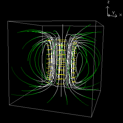
Electric Universe — Ionosphere-Surface Current
This theory states that the Earth is negatively charged, and that the atmosphere is a leaky capacitor, where there is a fair-weather current all of the time flowing from the Earth toward outer space, but that unique conditions can reduce the resistance within this capacitor, resulting in an enhanced current.241,242 One such condition would be the reduced pressure within a mesocyclone, which would increase the conductivity of the column of air from 1 km to over 12 km above the surface. This is only a fraction of the distance to the ionosphere, but it traverses the densest part of the atmosphere, and this is the source of 2⁄3 of the resistance between the surface and the ionosphere. Hence the mesocyclone could be opening up a conduit through which a current could flow.
The problem with this theory is that is does not explain vortexes that descend from non-mesocyclonic thunderstorms. It also does not take into account the fact that the global current is extremely weak. The "fair weather field" is something like .1 kV/m, which is vanishingly small compared to the fields in a thunderstorm. So it is far more likely that storm-generated fields are the only forces that could possibly be influential. It also labors under the same criticisms directed at the joule heating theory — the airflows in a discharge vortex are fundamentally different from those in a tornadic vortex.
Dmitriev et al. — Vacuum Domains
Review in progress.243
Büker and Tripoli — Analogous Thinking
This work suggests that similarities between formulas in thermodynamics and electromagnetism offer opportunities to merge the two disciplines on the basis of the similarities.244
For a clearer idea of what they're talking about, you'll have to read the paper. But just to give a (bad) example, let's consider merging the Coriolis Effect with the Lorentz force. Air approaching a tropical cyclone appears to be deflected to the right in the Northern Hemisphere because of the rotation of the Earth. If the air is charged, it will also be deflected, because it is generating a magnetic field, and in the presence of the Earth's magnetic field, there will be a ExB drift. Therefore, we can merge the two principles, and know more about both the Coriolis Effect and the Lorentz force because we picked up a few terms from both sets of equations. Now we can expect all cyclonic motion to be exhibiting electrodynamic effects, since we know by the Coriolis-Lorentz equations that these are coupled forces.
Figure 171. Analogies between hydrodynamics and electromagnetism, courtesy Büker and Tripoli.

Such reasoning is fatally flawed, and is a gross misinterpretation of the nature of EMHD on the part of the authors. Formulas in different disciplines might be the same, but unless they are the same for the same reasons, terms from one discipline cannot be substituted directly into formulas from the other.
Ironically, these authors would probably agree with the hypothesis presented in this paper, since the toroidal form is important in both fluid dynamics and in electromagnetism, and such proves that the formulas can be merged. But the present work would reject their approval. The central hypothesis is that because of the coincident forms, there is a positive feedback loop, and this is responsible for the emergence of a new property set. Toroidal flows don't know to be toroidal so physicists can re-use EM equations on them, and seeing superficial similarities in formulas does not deepen our appreciation of the underlying physics. It merely opens the door to category errors.
Anonymous — Cymatics
This theory states that tornadoes are caused (at least in part) by self-organizing sound waves. (See this for an example of the complex patterns that can appear in resonating fluids, or gases with particulate matter in them.)
This is a "anything's possible" theory that needs to be developed into a "this is possible" theory before it can be evaluated.
It should be noted that research has shown a clear relationship between the frequency of sound waves generated by a tornado and the size of the tornado.245 The researchers went so far as to say that very low frequency sound waves might be useful in tornado detection from a great distance. But whether these sound waves are artifacts or reentrant factors in their own right remains to be demonstrated.
Anonymous — Sun Spots
This theory hasn't been traced back to a specific source yet, but the idea is that tornadoes are most likely when Sun spot activity is the greatest.246
Interestingly, there does seem to be an inverse relationship between sunspots and tornado fatalities. Notice that in Figure 172, for the last 10 cycles, in each sunspot minimum there was only one peak in the fatality smoothed curve.
Figure 172. Tornado fatalities compared to sunspot cycles.

The nature of the relationship is unclear, but it's interesting to note that recent research at CERN on the CLOUD project has identified a correlation between sunspots and the strength of the Earth's geomagnetic fields (as the particles from CMEs augment the Earth's field), and a weaker field allows more cosmic rays to penetrate the atmosphere. These have been shown to increase the condensation of water vapor. Hence fewer CMEs result in more clouds. The extrapolation of this reasoning would be to the possibility that more clouds mean more storms.
Miscellaneous Probabilistic Theories
There are a wide variety of theories positing the existence of causal relationships between tornadogenesis and external factors.
Tornadoes are most likely above oil fields, since the oil has a net charge.247
Tornadoes are most likely above magma chambers, where magma flows are generating electric currents and magnetic fields.248
Tornadoes are most likely when gravity waves are passing through the air.249,250,251
Extreme weather in general is more likely when various alignments of the Sun and the planets are present.252
Tornadoes follow rivers, roads, railroad tracks, etc. (This has never been quantified.)
Tornadoes are most likely to start and stop at the transitions between positive and negative anomalies in the Earth's magnetic field. (The Earth's magnetic field is approximately 0.5 gauss, with local fluctuations of +/- 0.004 gauss, due to the magnetic properties of the crust. Click here to see a 7.18 MB image comparing tornado tracks with magnetic anomalies. The tornado track and magnetic anomaly data are not perfectly indexed — the projections and central meridians are slightly different. A better image will be posted when it becomes available.) Attempts to quantify the correlation are in progress.
None of these theories have demonstrated how the forces in question could explain the wide variety of distinctive properties of supercells and tornadoes.
Conclusion
There is no shortage of epiphanies within the solution domain, but the epiphanies do not pass the quickest of sanity checks. What is needed is a thoroughly considered theory that covers the length and breadth of the problem domain with plausible physics. Such has been, and will continue to be, the objective of the present work.
There are a wide variety of approaches to further developing these ideas. Which approach would return the most benefit for the least cost is still under consideration.
Computer Simulation
Generally the first place to start is to attempt a computer simulation of the proposed forces. While a pure physics simulation of the proposed EMHD interactions in such a complex system would be far too processor-intensive, a cheaper alternative would be to estimate the forces and to instantiate the effects in an algorithmic modulation of a thermodynamic simulation. Heuristics could be used to fine-tune the artificial forces until an exact solution is achieved. Then the model could be queried for specific values to compare against existing field data. If the model can achieve exact solutions faster, and if the model is applicable to a wider variety of storms with less fine-tuning, it would be more useful than existing modeling strategies.
This would still take a supercomputer, and supercomputer time takes money. Unfortunately, that kind of money isn't available for this kind of research, so this strategy will have to wait for later.
Laboratory Demonstration
One of the central contentions concerning tornadoes is that the inflowing air is positively charged, and that such inflow tends to hug the surface because of an induced electrostatic potential between it and the Earth. Then, it is released from that bond by an electric current through the low-pressure channel at the centerline. A simple laboratory apparatus could demonstrate this phenomenon, and the properties of the vortex so created could be compared to the properties of tornadic vortexes.
Plans for such an apparatus are here.
Field Studies
Space Charge Studies
One of the central tenets of the EMHD model is that the tornadic inflow is positively charged, and that the charge increases with proximity to the ground, as well as with proximity to the center of the inflow channel. Confirming this would take a space charge study.
It would be much easier to do such a study on waterspouts.
Off the Florida Keys, waterspouts are quite prevalent, so the chance of a successful intercept during peak season (i.e., late summer) is high.
Since waterspouts are consistently weak (≤ EF1), the risk of injury during an intercept is low.
Waterspouts typically move slowly and predictably, so they are easier and safer to intercept.
High-speed motorboats attempting intercepts can legally travel faster than cars on land.
Motorboats are not limited to roads. Traveling "as the crow flies" is faster, and opportunities won't be missed because there wasn't a passable road to the intercept point.
Motorboats are far more maneuverable than cars, at low and at high speeds.
The color of the water provides visible evidence of the near-surface flow field, providing information that would otherwise take a large array of anemometers.
Waterspouts don't have saltating and/or creeping particulate matter in the inflow channels that could perturb electric field and space charge studies.
Magnetometer Studies
The magnetic fields, of supercells and of the tornadoes themselves, should be studied.
Triggered Lightning Studies
The most incontrovertible test would be to see if lightning rockets could be used to downgrade or eliminate the tornado. If the central contention is that electromagnetism is an integral part of the structure of a supercell, then why don't we just try taking electromagnetism out of the equation and see what happens?
In addition to being the best test of the theory, it will also be a test of the practical application.
In order to conduct these tests, a certificate of authorization must be obtained from FAA. Unfortunately, one of FAA's requirements is that the research be publicly funded, and of course, there is no funding for this paradigm. So this will have to wait for the project to pick up more momentum from the other strategies listed above.
While the present proposal seems simple enough, it took a lot of work to extract that simplicity from a far larger body of literature. Yet the amount of work that remains to be done is staggering. The specificity and accuracy of the theory needs to be increased, and the theoretical implications of such increases need to be fully considered. If the theory persists, laboratory and field studies need to be conducted to further challenge it. Insofar as there is no funding for this line of reasoning, the work can only be done by volunteers. People with skills in fluid dynamics, thermodynamics, meteorology, electrostatics, electrodynamics, geophysics, plasma physics, computer programming, and radar can all add value to this project. Anyone wishing to contribute will share in the credit, and should e-mail the author to coordinate efforts.
Volunteers can also help advance this initiative simply by writing to their elected representatives, and urging them to fund research such as this. U.S. citizens can also write to the members of the relevant Senate Subcommittee. (When writing to congresspersons, do not bother to be verbose, as the letter is only going to be read by a congressional aide. Simply state the issue and which side of it you're on. This will get the letter into one stack or another. The representative will then be informed of the number of letters in each stack.)
The author cannot help but acknowledge the tireless efforts of the late Dr. Bernard Vonnegut, who almost single-handedly carried the EM torch for 40 years, regardless of the unanimous opinion of the meteorological community that he was wrong. Early in this paper, it was useful to distinguish the present work from Vonnegut's, as typically, anytime EM theories of tornadoes are presented, meteorologists simply practice their Vonnegut-bashing technique, and never bother to listen to what's actually being said. So it served the purposes of this initiative to say that this is definitely not the same as the previous generation's theory. But of the key evidence cited in this paper, more of it came from Vonnegut than from any other source. Had he not documented the distinctive EM properties of the tornadic storms in Toledo, OH, 1965-04-11, and in Huntsville, AL, 1974-04-03, and had he not investigated the EMHD properties of discharge vortexes, it would have been impossible to get all of the evidence sorted out into the present framework. So the present work's first and greatest debt is owed to this paradigm's earliest and staunchest supporter — thanks Dr. Vonnegut.
Figure 173. Bernard Vonnegut Jr., 1914~1997

The second debt is to Wallace Luchuk, who by his work in the late 1990s, and in numerous correspondences, taught the author to analyze tornadoes in fully mechanistic terms. Luchuk was also the first to clearly state that the primary energy conversion in a tornado is at the ground, which is central to the present work. We came to disagree on the solution, but with the correct approach and a well-defined problem, the rest is easy, and Luchuk gets the credit for paving the way for the present work.
Thanks to Kevin Linzey for listening patiently to many early versions of this theory, and for his clear-headed, objective analysis of each contention.
Thanks to Alexandra Duffy for editorial review of this paper.
Thanks to Kevin Johnston, Michael Gmirkin, Ernest Richars, Thomas Beck, Ronald Townsend, Carl Johnson, Roger Chandler, Jr., Tim Erney, Michael Harrington, Kiyoung Kim, Paul Olsen, Ron Graves, Vladislav Stanev, Hubert DeVries, and Roger Johnson for their many criticisms and suggestions.
1. Storm Prediction Center, 2000: Total cost of damage (most recent) by state, 1950-1996. statemaster.com
2. Changnon, S. A., 2009: Tornado Losses in the United States. Natural Hazards Review, 10(4): 145-150.
3. Storm Prediction Center, 2000: Tornadoes and deaths by year and month, 1950-1999. spc.noaa.gov
4. Rice, D., Welch, W. M., Leger, D. L., and Winter, M., 2013: Monster Oklahoma tornado kills 51. USA TODAY
5. Simmons, K. M., and Sutter, D., 2009: False Alarms, Tornado Warnings, and Tornado Casualties. Weather, Climate, and Society, 1: 38-53.
6. Simmons, K. M., and Sutter, D., 2008: Tornado Warnings, Lead Times, and Tornado Casualties: An Empirical Investigation. Weather and Forecasting, 23: 246-258.
7. Prevatt, D. O., van de Lindt, J. W., Graettinger, A., Coulbourne, W., Gupta, R., Pei, S., Hensen, S., Grau, D., 2011: Damage Study and Future Direction for Structural Design Following the Tuscaloosa Tornado of 2011. strongtie.com
8. Brooks, H. E., Doswell, C. A., and Sutter, D., 2008: Low-Level Winds in Tornadoes and Potential Catastrophic Tornado Impacts in Urban Areas. Bulletin of the American Meteorological Society, 89: 87-90.
9. OFCM/SDR, 2007: Multifunction Phased Array Radar (MPAR) Symposium Summary Report. Office of the Federal Coordinator for Meteorological Services and Supporting Research (OFCM), and the U.S. Office of Science and Technology Policy, Committee on Environment and Natural Resources, Subcommittee on Disaster Reduction
10. McLaughlin, D. J., Chandrasekar, V., Droegemeier, K., Frasier, S., Kurose, J., Junyent, F., Philips, B., Cruz-Pol, S., and Colom, J., 2005: Distributed Collaborative Adaptive Sensing (DCAS) for Improved Detection, Understanding, and Prediction of Atmospheric Hazards. 9th Symposium on Integrated Observing and Assimilation Systems for the Atmosphere, Oceans, and Land Surface (IOAS-AOLS), American Meteorological Society
11. Philips, B., Chandrasekar, V., Brotzge, J., Zink, M., Rodriguez, H., League, C., and Diaz, W., 2010: Performance of the CASA radar network during the May 13, 2009 Anadarko tornado. 15th Symposium on Meteorological Observation and Instrumentation, American Meteorological Society
12. Krasilnikov, E. Y., 1994: Solar power station: Energy source for suppression of destructive tropical cyclonic hurricanes. 45th International Astronautical Congress, Jerusalem, Israel, Oct. 9-14
13. Krasilnikov, E. Y., and Smakhtin, A. P., 1995: Microwave power from space for suppression of destructive tropical hurricanes. 46th International Astronautical Congress, Oslo, Norway, Oct. 2-6
14. Eastlund, B. J., 1998: Systems considerations of "Weather modification experiments using high power electromagnetic radiation". Workshop on Space Exploration and Resources Exploitation, Explospace, European Space Agency
15. Eastlund, B. J., 1999: Mesocyclone Diagnostic Requirements for the Thunderstorm Solar Power Satellite Concept. Proceedings of The Second Conference on the Applications of Remote Sensing and GIS for Disaster Management
16. Eastlund, B. J., and Jenkins, L. M., 2007: Taming Tornadoes Storm Abatement from Space. Aerospace and Electronic Systems Magazine, 22(6): 16-21.
17. Fiala, P., Sadek, V., and Kriz, T., 2008: Numerical Modeling of Electromagnetic Field a Tornado. Progress In Electromagnetics Research Symposium, Hangzhou, China, 1193-1197.
18. Rossow, V. J., 1966: Meteorology: A Short Circuit for Tornadoes. Time, Friday, Nov. 25.
19. Teramoto, K., and Ikeya, M., 2000: Experimental Study of Cloud Formation by Intense Electric Fields. Japanese Journal of Applied Physics, 39(5A): 2876.
20. Ikeya, M., 2004: Earthquakes and Animals: From Folk Legends to Science. World Scientific Publishing Company, pg. 178 in 295.
21. MacGorman, D. R., and Rust, W. D., 1998: The Electrical Nature of Storms. Oxford University Press, pgs. 52, 57, 73, 106, 110, 118, 164, 192 in 422.
22. Krasilnikov, E. Y., 2002: Prevention of destructive tropical and extratropical storms, hurricanes, tornadoes, dangerous thunderstorms, and catastrophic floods. Nonlinear Processes in Geophysics, 9: 51-59.
23. Okuda, H., and Kelly, A. J., 1996: Electrostatic atomization — Experiment, theory and industrial applications. Physics of Plasmas, 3: 2195.
24. Drake, G. W. F., 1996: Atomic, Molecular, & Optical Physics Handbook. American Institute of Physics, 1095 pages.
25. Nishida, K., Kiriyama, K., Kanaya, T., Kaji, K., and Okubo, T., 2004: Theoretical calculation of the reduced viscosity of aqueous suspensions of charged spherical particles. Journal of Polymer Science Part B: Polymer Physics, 42 (6): 1068-1074.
26. Wood, T. L., Corke, T. C., and Post, M., 2010: Plasma actuators for drag reduction on wings, nacelles and/or fuselage of vertical take-off and landing aircraft. United States Patent Application, 20100224733.
27. El-Khabiry, S., and Colver, G. M., 2011: Drag reduction by DC corona discharge along an electrically conductive flat plate for small Reynolds number flow. Physics of Fluids, 9(3): 587.
28. Vonnegut, B., Moore, C. B., and Harris, C. K., 1960: Stabilization of a high-voltage discharge by a vortex. Journal of the Atmospheric Sciences, 17: 468-471.
29. Anderson, F. J., Freier, G. D., Liu, C. C., and Tam, F. M., 1966: The Electric Field Changes during Tornadoes Compared with Other Severe Thunderstorms. Journal of Geophysical Research, 71: 4279.
30. Winn, W. P., Hunyady, S. J., and Aulich, G. D., 2000: Electric field at the ground in a large tornado. Journal of Geophysical Research, 105(D15): 20145-20154.
31. Burgess, D., 2006: Storm Electricity Aspects of the Blackwell/Udall Storm of 25 May 1955. srh.noaa.gov
32. Church, C. R., and Barnhart, B. J., 1979: A review of electrical phenomena associated with tornadoes. 11th Conference on Severe Local Storms, American Meteorological Society, 342-377.
33. Markowski, P., Majcen, M., Richardson, Y., Marquis, J., and Wurman, J., 2011: Characteristics of the Wind Field in a Trio of Nontornadic Low-Level Mesocyclones Observed by the Doppler On Wheels Radars. E-Journal of Severe Storms Meteorology, North America, 610 04 2011.
34. Beaty, W. J., 2009: Why does smoke "ring"? amasci.com
35. Lemon, L. R., and Doswell, C. A., 1979: Severe Thunderstorm Evolution and Mesocyclone Structure as Related to Tornadogenesis. Monthly Weather Review, 107: 1184-1197.
36. Davies-Jones, R. P., 1984: Streamwise Vorticity: The Origin of Updraft Rotation in Supercell Storms. Journal of the Atmospheric Sciences, 41: 2991-3006.
37. Klemp, J. B., 1987: Dynamics of Tornadic Thunderstorms. Annual Review of Fluid Mechanics, 19.
38. Lilly, D. K., and Jewett, B. F., 1990: Momentum and Kinetic Energy Budgets of Simulated Supercell Thunderstorms. Journal of the Atmospheric Sciences, 47: 707-726.
39. Doswell, C. A., and Burgess, D. W., 1992: Tornadoes and Tornadic Storms: A Review of Conceptual Models. American Geophysical Union, 161-172.
40. Davies-Jones, R. P., 1995: Tornadoes. Scientific American, 273(2).
41. NWS Louisville, 2004: Structure and dynamics of supercell thunderstorms. noaa.gov
42. Shimose, K., and Kawano, T., 2004: Numerical Simulation of Tornadogenesis in a Supercell Storm. Department of Earth and Planetary Sciences, Kyushu University, Fukuoka, Japan
43. Hassenzahl, H., 2007: Numerical Investigations of a Tornado Vortex Using Vorticity Confinement. wisc.edu
44. Markowski, P. M., and Richardson, Y. P., 2009: Tornadogenesis: Our current understanding, forecasting considerations, and questions to guide future research. Atmospheric Research, 93(1~3): 3-10.
45. Brooks, H. E., and Wilhelmson, R. B., 1992: Numerical simulation of a low-precipitation supercell thunderstorm. Meteorology and Atmospheric Physics, 49(1~4).
46. Steinhoff, J., and Underhill, D., 1994: Modification of the euler equations for "vorticity confinement": Application to the computation of interacting vortex rings. Physics of Fluids, 6(8): 2738-2744.
47. Snyder, C., and Zhang, F., 2003: Assimilation of simulated Doppler radar observations with an ensemble Kalman filter. Monthly Weather Review, 131, 1663-1677.
48. Dowell, D., Zhang, F., Wicker, L. J., Snyder, C., and Crook, N. A., 2004: Wind and thermodynamic retrievals in the 17 May 1981 Arcadia, Oklahoma supercell: Ensemble Kalman filter experiments. Monthly Weather Review, 132, 1982-2005.
49. Dowell, D. C., Wicker, L. J., and Stensrud, D. J., 2004: High resolution analyses of the 8 May 2003 Oklahoma City storm. Part II: EnKF data assimilation and forecast experiments. 22nd Conf. on Severe Local Storms, Hyannis, Massachusetts, paper 12.5
50. Tong, M., and Xue, M., 2005: Ensemble Kalman filter assimilation of Doppler radar data with a compressible nonhydrostatic model: OSS experiments. Monthly Weather Review, 133, 1789-1807.
51. Caya, A., Sun, J., and Snyder, C., 2005: A comparison between the 4D-Var and the ensemble Kalman filter techniques for radar data assimilation. Monthly Weather Review, 133, 3081-3094.
52. Tong, M., and Xue, M., 2007: Simultaneous estimation of microphysical parameters and atmospheric state with radar data and ensemble square-root Kalman filter. Part I: Sensitivity analysis and parameter identifiability. Part II: Parameter estimation experiments. Journal of the Atmospheric Sciences (submitted)
53. Aksoy, A., Dowell, D. C., and Snyder, C., 2007: A multi-case study of ensemble-based assimilation of radar observations into cloud resolving WRF using DART. 18th Conference on Numerical Weather Prediction, American Meteorological Society
54. Trapp, R. J., Stumpf, G. J., and Manross, K. L., 2005: A reassessment of the percentage of tornadic mesocyclones. Weather and Forecasting, 20, 23-34.
55. MacGorman, D. R., Rust, W. D., Krehbiel, P., Rison, W., Bruning, E., and Wiens, K., 2005: The Electrical Structure of Two Supercell Storms during STEPS. Monthly Weather Review, 133: 2583-2607.
56. Kuhlman, K. M., Ziegler, C. L., Mansell, E. R., MacGorman, D. R., and Straka, J. M., 2006: Numerically Simulated Electrification and Lightning of the 29 June 2000 STEPS Supercell Storm. Monthly Weather Review, 134: 2734-2757.
57. Sommer, A. P., and Levin, Z., 2001: Charge transfer in convective thunderclouds induced by molecular interface crossing and free energy reduction. Atmospheric Research, 58(2): 129-139.
58. Chen, S. H., 2008: Thunderstorms. ucdavis.edu
59. Zhang, Y., Krehbiel, P., Hamlin, T., Harlin, J., Thomas, R., and Rison, W., 2001: Electrical Charge Structure and Cloud-to-Ground Lightning in Thunderstorms during STEPS. American Geophysical Union, Fall Meeting 2001, abstract #AE12A-0079.
60. Marshall, T. C., and Stolzenburg, M., 2001: Voltages inside and just above thunderstorms. Journal of Geophysical Research, 106(D5), 4757-4768.
61. Vonnegut, B., 1979: Tropospheric electrification. NASA Goddard Space Flight Center Middle Atmosphere Electrodynamics, N79-25608 16-46, 157-168.
62. Jensenius, J., 2007: Science of Lightning. lightningsafety.noaa.gov
63. Knupp, K. R., Paech, S., and Goodman, S., 2003: Variations in Cloud-to-Ground Lightning Characteristics among Three Adjacent Tornadic Supercell Storms over the Tennessee Valley Region. Monthly Weather Review, 131: 172-188.
64. Blyth, A. M., Cooper, W. A., and Jensen, J. B., 1988: A Study of the Source of Entrained Air in Montana Cumuli. Journal of the Atmospheric Sciences, 45: 3944-3964.
65. Stith, J. L., 1992: Observations of Cloud-Top Entrainment in Cumuli. Journal of the Atmospheric Sciences, 49: 1334-1347.
66. Snow, J. T., 1984: The tornado. Scientific American, 250, 4, 56-65.
67. Trapp, R. J., Mitchell, E. D., Tipton, G. A., Effertz, D. W., Watson, A., Andra, D. L., and Magsig, M. A., 1999: Descending and nondescending tornadic vortex signatures detected by WSR-88Ds. Weather and Forecasting, 14 (5), 625-639.
68. Binau, S., and Baumgardt, D. A., 2005: Storm mode evolution from a quasi-linear convective system to a discrete tornadic supercell during the historic Wisconsin tornado outbreak of 18 August 2005: a radar perspective. 23rd Conference on Severe Local Storms, American Meteorological Society
69. Doswell, C. A., 1991: A review for forecasters on the application of hodographs to forecasting severe thunderstorms. National Weather Digest, 16 (1), 2-16.
70. Gerbeth, G., Dulikravich, G. S., and Pericleous, K., 2008: Computational electro-magneto-hydro-dynamics (EMHD). 8th World Congress on Computational Mechanics (WCCM8), Venice, Italy
71. Zeng, Z., Yuter, S. E., Houze, R. A., and Kingsmill, D. E., 2001: Microphysics of the Rapid Development of Heavy Convective Precipitation. Monthly Weather Review, 129: 1882-1904.
72. NSSL, 2009: Questions and Answers about Hail. nssl.noaa.gov
73. Wåhlin, L., 1994: Elements of fair weather electricity. Journal of Geophysical Research, 99(D5): 10,767-10,772.
74. Cummings, M. R., Nicholson, H. W., and Porto, D. R., 1981: Measurement of the atmospheric electrostatic potential gradient near sea level. American Journal of Physics, 49(12): 1178-1180.
75. Smith, J. D., Cappa, C. D., Wilson, K. R., Cohen, R. C., Geissler, P. L., and Saykally, R. J., 2005: Unified description of temperature-dependent hydrogen bond rearrangements in liquid water. Proceedings of the National Academy of Sciences USA, 102 (40): 14171-14174.
76. Mason, J., and Mason, N., 2003: The physics of a thunderstorm. European Journal of Physics, 24(5), S99.
77. Xu, H. B., and Duan, Y., 2001: The Mechanism of Hailstone's Formation and the Hail-Suppression Hypothesis: Beneficial Competition. Chinese Journal of Atmospheric Sciences
78. Xu, H. B., Duan, Y., and Liu, H. Y., 2004: The Physics of Hailstorm and the Principle and Design of Hail Suppression. Beijing: Meteorology Press
79. Browning, K. A., 1964: Airflow and Precipitation Trajectories Within Severe Local Storms Which Travel to the Right of the Winds. Journal of the Atmospheric Sciences, 21, 634-639.
80. Hare, R., 1838: In "An attempt to develop the law of storms by means of facts, arranged according to place and time," by Sir William Reid. London: J. Weale
81. Landsea, C., 2006: Which is the most intense tropical cyclone on record? noaa.gov
82. Maddox, R. A., 1976: An evaluation of tornado proximity wind and stability data. Monthly Weather Review, 104: 133-142.
83. Bunkers, M. J., Klimowski, B. A., Zeitler, J. W., Thompson, R. L., and Weisman, M. L., 2000: Predicting supercell motion using a new hodograph technique. Weather and Forecasting, 15: 61-79.
84. Edwards, R., Thompson, R. L., and Hart, J. A., 2002: Verification of Supercell Motion Forecasting Techniques. spc.noaa.gov
85. Krehbiel, P. et al, 2000: Tornadic Storm of June 29, 2000. lightning.nmt.edu
86. Edwards, R., 2006: Bat-eating Supercell. spc.noaa.gov
87. Gallagher, F. W., Beasley, W. H., and Bohren, C. F., 1996: Green Thunderstorms Observed. Bulletin of the American Meteorological Society, 77: 2889-2897.
88. Gallagher, F. W., 2000: Distant Green Thunderstorms — Fraser's Theory Revisited. Journal of Applied Meteorology, 39, 1754-1761.
89. NSSL, 2008: Frequently Asked Questions About Hail. nssl.noaa.gov
90. Freier, G. D., 1992: Weather Proverbs: How 600 Proverbs, Sayings and Poems Accurately Explain Our Weather. Tucson: Fisher Books
91. Fankhauser, J. C., Barnes, G. M., Miller, L. J., and Roskowski, P. M., 1983: Photographic documentation of some distinctive cloud forms observed beneath a large cumulonimbus. Bulletin of the American Meteorological Society, 64(5): 450-450.
92. Gallagher, F. W., and Beasley, W. H., 2003: Evaluation of a one-dimensional cloud model for yellow and green thunderstorms. Applied Optics, 42, 505-510.
93. Wåhlin, L., 1986: Atmospheric Electrostatics. Research Studies Press LTD., Letchworth, Hertfordshire, England, pg 28 in 120.
94. Köppen, J., 2007: Spectrum of Nitrogen Gas Discharge. u-strasbg.fr
95. Knight, M., 2007: Fact or Fiction?: If the Sky Is Green, Run for Cover — A Tornado Is Coming. Scientific American
96. Kilty, K., 2005: Steady-state tornado vortex models. kilty.com
97. Luchuk, W., 1999: The Tornado From An Aerodynamicist's Point of View. cafes.net/wallytul
98. Trapp, R. J., 1999: Observations of Nontornadic Low-Level Mesocyclones and Attendant Tornadogenesis Failure during VORTEX. Monthly Weather Review, 127, 1693-1705.
99. Wakimoto, R. M., Cai, H., and Murphey, H. V., 2004: The Superior, Nebraska, supercell during BAMEX. Bulletin of the American Meteorological Society, 85, 1095-1106.
100. Bluestein, H. B., and Pazmany, A. L., 2000: Observations of tornadoes and other convective phenomena with a mobile 3-mm wavelength Doppler radar: The spring 1999 field experiment. Bulletin of the American Meteorological Society, 81: 2939-2951.
101. Makarieva, A. M., Gorshkov, V. G., and Nefiodov, A. V., 2011: Condensational theory of stationary tornadoes. Physics Letters A, 375(24): 2259-2261.
102. Lee, J. J., Samaras, T., and Young, C., 2004: Pressure measurements at the ground in an F-4 tornado. 22nd Conference on Severe Local Storms, American Meteorological Society
103. Trivedi, B. P., 2003: Storm Chaser Deploys Probe, Makes History. nationalgeographic.com
104. Wilkins, E. M., 1964: The Role of Electrical Phenomena Associated with Tornadoes. Journal of Geophysical Research, 69: 2435.
105. Vonnegut, B., and Moore, C. B., 1957: Electrical activity associated with the Blackwell-Udall tornado. Journal of Meteorology, 14: 284-285.
106. Vonnegut, B., 1960: The Electrical Theory of Tornadoes. Journal of Geophysical Research, 65: 203-212.
107. Colgate, S. A., 1967: Tornadoes: Mechanism and Control. Science, 157(3795): 1431-1434.
108. Ryan, R. T., and Vonnegut, B., 1970: Miniature Whirlwinds Produced in the Laboratory by High-Voltage Electrical Discharges. Science, 168(3937): 1349-1351.
109. Sozou, C., 1984: Electrical Discharges and Intense Vortices. Proceedings of the Royal Society of London, Series A, Mathematical and Physical Sciences, 392(1803): 415-426.
110. Jonsson, H. H., and Vonnegut, B., 1993: Miniature vortices produced by electrical corona. Journal of Geophysical Research, 98(D3): 5245-7126.
111. Greneker, E. F., Wilson, C. S., and Metcalf, J. I., 1976: The Atlanta Tornado of 1975. Monthly Weather Review, 104: 1052-1057.
112. Brook, M., 1967: Electric Currents Accompanying Tornado Activity. Science, 157(3795): 1434-1436.
113. Watkins, D. C., Cobine, J. D., and Vonnegut, B., 1978: Electric discharges inside tornados. Science, 199: 171-174.
114. Berson, F. A., and Power, H., 1972: On the geo-electromagnetic aspects of tornado initiation. Pure and Applied Geophysics, 101(1): 221-230.
115. Freier, G. D., 1959: The Earth's Electric Field during a Tornado. Journal of the Atmospheric Sciences, 16(3): 333-334.
116. Gunn, R., 1956: Electric field intensity at the ground under active thunderstorms and tornadoes. Journal of the Atmospheric Sciences, 13: 269-273.
117. Buechler, D. E., Driscoll, K. T., Goodman, S. J., and Christian, H. J., 2000: Lightning activity within a tornadic thunderstorm observed by the optical transient detector (OTD). Geophysical Research Letters, 27(15): 2253-2256.
118. Murphy, M. J., and Demetriades, N. W. S., 2005: An analysis of lightning holes in a DFW supercell storm using total lightning and radar information. Conference on Meteorological Applications of Lightning Data, 2.3.
119. Steiger, S. M., Orville, R. E., and Carey, L. D., 2007: Total Lightning Signatures of Thunderstorm Intensity over North Texas. Part I: Supercells. Monthly Weather Review, 135: 3281-3302.
120. Trostel, J. M., and Matthews, J., 2010: Application of an Improved SCIT Algorithm to Investigate Lightning Characteristics of a Tornado Outbreak in Georgia. 26th Conference on Interactive Information and Processing Systems (IIPS) for Meteorology, Oceanography, and Hydrology
121. Rathbun, E. R., 1960: An Electromagnetic Basis for the Initiation of a Tornado. Journal of the Atmospheric Sciences, 17: 371-373.
122. Silberg, P., 1966: Dehydration and Burning Produced by the Tornado. Journal of the Atmospheric Sciences, 23: 202-205.
123. Rossow, V. J., 1967: A study of an electrostatic-motor drive for tornado vortices. 8th Symposium on Engineering Aspects of Magnetohydrodynamics, Stanford, CA, 60-68.
124. Krasilnikov, E. Y., 1997: Electromagnetohydrodynamic nature of tropical cyclones, hurricanes, and tornadoes. Journal of Geophysical Research, 102(D12): 13571-13580.
125. Kikuchi, H., 2005: EHD Approach to Tornadic Thunderstorms and Methods of Their Destruction. American Geophysical Union, Spring Meeting 2005, abstract #AE11B-01.
126. Thomsom, P., 2005: Charge Sheath Vortex - Plasma Production Modes. peter-thomson.co.uk
127. Scherbin, M. D., 2005: On Possibility of Electromagnetic Nature of Atmospheric Intensive Vortices Generation. arXiv:physics, 0512239.
128. Dehel, T. F., Dickinson, M., Lorge, F., and Startzel, F. Jr., 2007: Electric field and Lorentz force contribution to atmospheric vortex phenomena. Journal of Electrostatics, 65(10~11): 631-638.
129. Kikuchi, H., 2007: Helicity or Vortex Generation in Hydrodynamic (HD), Magneto-hydrodynamic (MHD), and Electrohydrodynamic (EHD) Regimes. Progress In Electromagnetics Research Symposium 2007, Beijing, China, March 26-30
130. Patton, F. S, Bothun, G. D., and Sessions, S. L., 2008: An electric force facilitator in descending vortex tornadogenesis. Journal of Geophysical Research, 113, D07106, doi:10.1029/2007JD009027.
131. Schmitter, E. D., 2010: Modeling tornado dynamics and the generation of infrasound, electric and magnetic fields. Natural Hazards and Earth System Sciences, 10: 295-298.
132. Markowski, P. M., Straka, J. M., and Rasmussen, E. N., 2002: Direct Surface Thermodynamic Observations within the Rear-Flank Downdrafts of Nontornadic and Tornadic Supercells. Monthly Weather Review, 130: 1692-1721.
133. Rust, W. D., MacGorman, D. R., Bruning, E. C., Weiss, S. A., Krehbiel, P. R., Thomas, R. J., Rison, W., Hamlin, T., and Harlin, J., 2005: Inverted-polarity electrical structures in thunderstorms in the Severe Thunderstorm Electrification and Precipitation Study (STEPS). Atmospheric Research, 76: 247-271.
134. Tessendorf, S. A., Wiens, K. C., Lang, T., and Rutledge, S. A., 2006: STEPS 2000 Research Highlights From Colorado State University. American Geophysical Union, Fall Meeting 2006, abstract #AE43A-05.
135. Tessendorf, S. A., Rutledge, S. A., and Wiens, K. C., 2007: Radar and lightning observations of normal and inverted polarity multicellular storms from STEPS. Monthly Weather Review, 135: 3682-3706.
136. Yih, C. S., 2007: Tornado-like flows. Physics of Fluids, 19: 076601.
137. Renno, N. O. D., and Bluestein, H. B., 2001: A Simple Theory for Waterspouts. Journal of the Atmospheric Sciences, 58(8): 927-932.
138. Winn, W. P., Hunyady, S. J., and Aulich, G. D., 1999: Pressure at the ground in a large tornado. Journal of Geophysical Research, 104(D18): 22,067-22,082.
139. Taflin, D. C., Ward, T. L., and Davis, E. J., 1989: Electrified droplet fission and the Rayleigh limit. Langmuir, 5 (2): 376-384.
140. Markowski, P. M., 2002: Hook Echoes and Rear-Flank Downdrafts: A Review. Monthly Weather Review, 130, 852-876.
141. Brandes, E. A., 1978: Mesocyclone evolution and tornadogenesis: Some observations. Monthly Weather Review, 106, 995-1011.
142. Rasmussen, E. N., Peterson, R. E., Minor, J. E., and Campbell, B. D., 1982: Evolutionary characteristics and photogrammetric determination of windspeeds within the Tulia outbreak tornadoes 28 May 1980. 12th Conference on Severe Local Storms, American Meteorological Society, 301-304.
143. Jensen, B., Marshall, T. P., Mabey, M. A., and Rasmussen, E. N., 1983: Storm scale structure of the Pampa storm. 13th Conference on Severe Local Storms, American Meteorological Society, 85-88.
144. Lee, B. D., Finley, C. A., and Samaras, T. M., 2008: Thermodynamic and kinematic analysis near and within the Tipton, KS tornado on May 29 during TWISTEX 2008. 24th Conference on Severe Local Storms, American Meteorological Society
145. Hocking, W., 2010: What caused the Leamington tornado? Western professor has a theory. Western University Press
146. Pawar, S. D., and Kamra, A. K., 2000: Comparative measurements of the atmospheric electric space charge density made with the filtration and Faraday cage techniques. Atmospheric Research, 54(2-3): 105-116.
147. Stolzenburg, M., Marshall, T. C., and Krehbiel, P. R., 2010: Duration and extent of large electric fields in a thunderstorm anvil cloud after the last lightning. Journal of Geophysical Research, 115: D19202.
148. Anonymous, 2009: List of weather records. wikipedia.org
149. Karstens, C. D., Gallus, W. A. Jr., Samaras, T. M., Lee, B. D., and Finley, C. A., 2010: Near-ground Pressure and Wind Measurements in Tornadoes. Monthly Weather Review
150. NSSL, 2009: Tornado Basics. nssl.noaa.gov
151. Snow, J. T., 1984: On the formation of particle sheaths in columnar vortices. Journal of the Atmospheric Sciences, 41(16): 2477-2491.
152. Wurman, J., 2002: The multiple vortex structure of a tornado. Weather and Forecasting, 17: 473-505.
153. Sarkar, P. P., Haan, F. L. Jr., Gallus, W. A. Jr., Le, K., and Wurman, J., 2005: Velocity Measurements in a Laboratory Tornado Simulator and their comparison with Numerical and Full-Scale Data. Technical Memorandum of Public Works Research Institute, 3983: 197-211.
154. Alexander, C. R., Wurman, J., 2005: The 30 May 1998 Spencer, South Dakota, Storm. Part I: The Structural Evolution and Environment of the Tornadoes. Monthly Weather Review, 133: 72-96.
155. Wurman, J., Alexander, C. R., 2005: The 30 May 1998 Spencer, South Dakota, Storm. Part II: Comparison of Observed Damage and Radar-Derived Winds in the Tornadoes. Monthly Weather Review, 133: 97-118.
156. Edwards, R., 1998: Tornado with Subvortex Filaments. stormeyes.org
157. Vonnegut, B., and Weyer, J. R., 1966: Luminous Phenomena in Nocturnal Tornadoes. Science, 153(3741): 1213-1220.
158. Vaughan, O. H. Jr., and Vonnegut, B., 1976: Luminous Electrical Phenomena Associated with Nocturnal Tornadoes in Huntsville, Alabama. Bulletin of the American Meteorological Society, 57(10): 1220-1220.
159. Reynolds, D. J., 1995: Nocturnal Tornado Illuminated by an Electrical Discharge at Farnham, Surrey, 10 January 1994. Journal of Meteorology, UK, 20: 381.
160. Beaty, W. J., 2007: What causes the strange glow known as St. Elmo's Fire? Is this phenomenon related to ball lightning? Scientific American
161. Justice, A. A., 1930: Seeing the Inside of a Tornado. Monthly Weather Review, 58: 205-206.
162. Hall, R. S., 1987: Inside A Texas Tornado. Weatherwise, 40: 73.
163. McGown, D., 1996: Looking Up Into A Tornado Funnel. Time, 147: 8.
164. Lewis, E., 1996: Tornadoes and Ball Lightning. padrak.com
165. Davies-Jones, R. P., and Golden, J. H., 1975: On the Relation of Electrical Activity to Tornadoes. Journal of Geophysical Research, 80(12), 1614-1616.
166. Ward, N. B., 1972: The exploration of certain features of tornado dynamics using a laboratory model. Journal of the Atmospheric Sciences, 29: 1194-1204.
167. Church, C. R., Snow, J. T., and Agee, E. M., 1977: Tornado Vortex Simulation at Purdue University. Bulletin of the American Meteorological Society, 58, 900-908.
168. Rotunno, R., 1977: Numerical simulation of a laboratory vortex. Journal of the Atmospheric Sciences, 34: 1942-1956.
169. Rotunno, R., 1979: A Study in Tornado-Like Vortex Dynamics. Journal of the Atmospheric Sciences, 36, 140-155.
170. Snow, J. T., 1982: A review of recent advances in tornado vortex dynamics. Reviews of Geophysics, 20(4), 953-964.
171. Church, C. R., and Snow, J. T., 1993: Laboratory models of tornadoes. In "The Tornado: its structure, dynamics, prediction, and hazards". American Geophysical Union, Monograph 79: 277-295.
172. Ladue, J., 1993: Vortex formation from a helical inflow tornado vortex simulator. In "The Tornado: its structure, dynamics, prediction, and hazards". American Geophysical Union, Monograph 79: 307-316.
173. Fouts, J. L., 2003: Flow visualization and fluid-structure interaction of tornado-like vortices. Texas Tech University Library
174. Gallus, W. A. Jr., Sarkar, P. P., Haan, F. L. Jr., Le, K., Kardell, R., and Wurman, J., 2004: A translating tornado simulator for engineering tests: comparison of radar, numerical model, and simulator winds. 22nd Conference on Severe Local Storms, American Meteorological Society
175. Haan, F. L. Jr., Sarkar, P. P., and Gallus, W. A. Jr., 2008: Design, construction and performance of a large tornado simulator for wind engineering applications. Engineering Structures, 30(4): 1146-1159.
176. Le, K., Haan, F. L. Jr., Gallus, W. A. Jr., and Sarkar, P. P., 2008: CFD simulations of the flow field of a laboratory-simulated tornado for parameter sensitivity studies and comparison with field measurements. Wind and Structures
177. Hu, H., Yang, Z., Sarkar, P. P., and Haan, F. L. Jr., 2011: Characterization of the wind loads and flow fields around a gable-roof building model in tornado-like winds. Experiments in Fluids, 51(3): 835-851.
178. Lewellen, D. C., Gong, B., and Lewellen, W. S., 2007: Effects of Fine-Scale Debris on Near-Surface Tornado Dynamics. Journal of the Atmospheric Sciences
179. Lee, W., and Wurman, J., 2001: Diagnosed Structure of the Mulhall Tornado Using VTD Algorithm. 30th International Conference on Radar Meteorology
180. Falconer, R. E., and Schaefer, V. J., 1954: Bulletin of the American Meteorological Society, 35, 437.
181. Grazulis, T., 2007: Things that have been "carried" by a tornado. tornadoproject.com
182. Beard, D., 2007: Survivors recount night of tornado. journalenterprise.com
183. Keeton, K., 2010: personal correspondence.
184. Schmidlin, T. W., Hammer, B. O., King, P. S., and Miller, L. S., 2003: Wind speeds required to upset vehicles. Symposium on the F-Scale and Severe-Weather Damage Assessment, American Meteorological Society
185. The Associated Press, 2006: Missouri teen survives tornado. usatoday.com
186. Heckert, P. A., 2007: Bernoulli's Principle and Storms. suite101.com
187. Minor, J. E., McDonald, J. R., and Mehta, K. C., 1993: The tornado: an engineering-oriented perspective. NOAA Technical Memorandum, NWS SR-147.
188. Byers, H. R., and Braham, R. R. Jr., 1949: The Thunderstorm: Final Report of the Thunderstorm Project. Washington, DC: U.S. Government Printing Office, 282 pgs.
189. Battan, L. J., 1964: The Thunderstorm. Signet
190. Edwards, R., 2009: The online tornado FAQ. spc.noaa.gov
191. Oliver, R., 2010: personal correspondence.
192. Kosiba, K., and Wurman, J., 2010: The three-dimensional axisymmetric wind field structure of the Spencer, South Dakota (1998) tornado. Journal of the Atmospheric Sciences
193. Marshall, T., 1999: Damage survey of the Moore, Oklahoma tornado. stormtrack.org
194. Wurman, J., and Kosiba, K. A., 2008: DOW observations of multiple vortex structure in several tornadoes. 24th Conference on Severe Local Storms, American Meteorological Society
195. Orville, R. E., 1994: Cloud-to-ground lightning flash characteristics in the contiguous United States: 1989-1991. Journal of Geophysical Research, 99(D5), 10,833-10,841.
196. Biggar, D. G., 2000: A case study of a positive strike dominated supercell thunderstorm that produced an F2 tornado after undergoing a significant cloud-to-ground lightning polarity shift. srh.noaa.gov
197. Perez, A. H., Wicker, L. J., and Orville, R. E., 1997: Characteristics of Cloud-to-Ground Lightning Associated with Violent Tornadoes. Weather and Forecasting, 12: 428-437.
198. Kennedy, R. E., and Fredrich, E. R., 1989: Tornado warning system. freepatentsonline.com, 4812825.
199. Jones, H. L., 1955: Research on Tornado Identification. 3rd Quarter Progress Report, Contract No. DA 36-039 SC 64436, Stillwater, Okla. A. and M. College, 8-35.
200. Jenkins, H. H., and Wilson, C. S., 1977: Research instrumentation for tornado electromagnetics emissions detection. Final Technical Summary Report, Feb. 1975 - Jan. 1977, Georgia Institute of Technology, Atlanta
201. Taylor, W. L., Brandes, E. A., Rust, W. D., and MacGorman, D. R., 1984: Lightning Activity and Severe Storm Structure. Geophysical Research Letters, 11(5), 545-548.
202. Leeman, J. R., and Schmitter, E. D., 2008: Electric signals generated by tornados. Atmospheric Research, 92(2): 277-279.
203. Alcorn, M., 1998: What Is Lightning And How Does Lightning Form. met.tamu.edu
204. Boccippio, D. J., Williams, E. R., Heckman, S. J., Lyons, W. A., Baker, I. T., and Boldi, R., 1995: Sprites, ELF Transients, and Positive Ground Strokes. Science, 269 (5227): 1088-1091.
205. Taylor, W., 1973: Electromagnetic Radiation from Severe Storms in Oklahoma during April 29-30, 1970. Journal of Geophysical Research, 78(36), 8761-8777.
206. Schecter, D. A., Nicholls, M. E., Persing, J., Bedard, A. J., and Pielke, R. A., 2008: Infrasound Emitted by Tornado-Like Vortices: Basic Theory and a Numerical Comparison to the Acoustic Radiation of a Single-Cell Thunderstorm. Journal of the Atmospheric Sciences, 65: 685-713.
207. Erney, T., 2009: personal correspondence.
208. Flora, S. D., 1954: Tornadoes of the United States. Norman, OK: University of Oklahoma Press, 221 pgs.
209. Abdullah, A. J., 1966: The "musical" sound emitted by a tornado. Monthly Weather Review, 94, 213-220.
210. Fleming, J. A. (editor), 1939: Terrestrial Magnetism and Electricity. New York and London: McGraw-Hill, pg. 660 in 794.
211. Vaughan, O. H. Jr., and Vonnegut, B., 1976: Luminous electrical phenomena in Huntsville, Alabama, tornadoes on April 3, 1974. NASA Technical Reports, TMX-73301.
212. Hartwig, S., Voigt, J., Scheer, H., Albrecht, H., Burghoff, M., and Trahms, L., 2011: Nuclear magnetic relaxation in water revisited. The Journal of Chemical Physics, 135: 054201.
213. Desktop Aeronautics, 2009: General Theory of Aerodynamics. desktopaero.com
214. Schultz, D. M., Kanak, K. M., Straka, J. M., Trapp, R. J., Gordon, B. A., Zrnić, D. S., Bryan, G. H., Durant, A. J., Garrett, T. J., Klein, P. M., and Lilly, D. K., 2006: The Mysteries of Mammatus Clouds: Observations and Formation Mechanisms. Journal of the Atmospheric Sciences, 63, 2409-2435.
215. Golden, J. H., and Purcell, D., 1978: Life cycle of the Union City, Oklahoma tornado and comparison with waterspouts. Monthly Weather Review, 106: 3-11.
216. Caruso, J. M., and Davies, J. M, 2005: Tornadoes in Nonmesocyclone Environments with Pre-existing Vertical Vorticity along Convergence Boundaries. Electronic Journal of Operational Meteorology
217. Sanders, R., 2002: Stalking Arizona dust devils helps scientists understand electrical, atmospheric effects of dust storms on Mars. berkeley.edu
218. Renno, N. O., Abreu, V. J., Koch, J., Smith, P. H., Hartogensis, O. K., De Bruin, H. A. R., Burose, D., Delory, G. T., Farrell, W. M., Watts, C. J., Garatuza, J., Parker, M., and Carswell, A., 2004: MATADOR 2002: A pilot field experiment on convective plumes and dust devils. Journal of Geophysical Research, 109, E07001.
219. Saarenketo, T., 2001: Measuring electromagnetic properties of asphalt for pavement quality control and defect mapping. Roadscanners, 1-13.
220. Cerveny, R., and Schaefer, J. T., 2002: Tornado oddities: wild and inexplicable stories reveal the freakish nature and amazing power of tornadoes. Weatherwise, Jul/Aug: 20-28.
221. Snow, R., Snow, M., and Kufa, N., 2007: Lightning Signature Assessment to Forecast Tornado Formation. International Journal of Energy and Environment, 1(1): 7-11.
222. Kalra, C. S., Kossitsyn, M., Iskenderova, K., Chirokov, A., Cho, Y. I., Gutsol, A., and Fridman, A., 2003: Electrical discharges in the Reverse Vortex Flow - Tornado Discharges. Electronic Proceedings of 16th International Symposium on Plasma Chemistry, Taormina, Italy
223. Kalra, C. S., Cho, Y. I., Gutsol, A., Fridman, A., and Rufael, T. S., 2005: Gliding arc in tornado using a reverse vortex flow. Review of Scientific Instruments, 76, 025110.
224. Chakraborty, P., Gioia, G., and Kieffer, S. W., 2009: Volcanic mesocyclones. Nature, 458, 497-500.
225. Self, S., Zhao, J. X., Holasek, R. E., Torres, R. C., and King, A. J., 1999: The Atmospheric Impact of the 1991 Mount Pinatubo Eruption. usgs.gov
226. Oswalt, J. S., Nichols, W., and O'Hara1, J. F., 1999: Meteorological Observations of the 1991 Mount Pinatubo Eruption. usgs.gov
227. Thomas, R. J., Krehbiel, P. R., Rison, W., Edens, H. E., Aulich, G. D., Winn, W. P., McNutt, S. R., Tytgat, G., and Clark, E., 2007: Electrical Activity During the 2006 Mount St. Augustine Volcanic Eruptions. Science, 315 (5815): 1097.
228. Doswell, C. A., Weiss, S. J., and Johns, R. H., 1993: Tornado Forecasting: A Review. American Geophysical Union, 79: 557-571.
229. Moller, A. R., Doswell, C. A., Foster, M. P., and Woodall, G. R., 1994: The Operational Recognition of Supercell Thunderstorm Environments and Storm Structures. Weather and Forecasting, 9(3): 327-347.
230. Bradford, M., 1999: Historical Roots of Modern Tornado Forecasts and Warnings. Weather and Forecasting, 14: 484-491.
231. Holden, J., and Wright, A., 2004: UK tornado climatology and the development of simple prediction tools. Quarterly Journal of the Royal Meteorological Society, 130: 1009-1021.
232. Uman, M. A., and Rakov, V. A., 2008: University of Florida Lightning Research Group. lightning.ece.ufl.edu
233. Kridler, C., 2002: July 25, 2002, triggered lightning video. skydiary.com
234. Anonymous, 2008: Lightning rocket. wikipedia.org
235. Ball, L. M., 1977: Laser lightning rod system. freepatentsonline.com, 4017767.
236. Thompson, J. J., Thompson, G. P., 1933: Conduction of Electricity Through Gases. Cambridge University Press
237. Kikuchi, H., 2007: Laboratory Experiments of Helicity or Vortex Generation in an Electric Quadrupole: Simulation of Tonadoes with and without Lightning. American Geophysical Union Spring Meeting Abstracts, #SA54A-02.
238. Kikuchi, H., 2008: Usefulness of a Universal Electric-cusp Type Plasma Reactor in Basic Studies and a Variety of Applications in Dust Dynamics, Ionization and Discharge Physics Based on Electrohydrodynamics. PIERS Proceedings (Hangzhou, China), 1218-1222.
239. Heene, R., Stevens, R., and Slusser, B., 2008: Electromagnetic Fields Recorded in Mesocyclones. National Weather Digest, 32:1, 35-44.
240. Anonymous Faculty, 2008: The Real Levitation. hfml.ru.nl
241. Scott, D. E., 2007: Real Properties of Electromagnetic Fields and Plasma in the Cosmos. IEEE Transactions on Plasma Science, 35(4).
242. Scott, D. E., 2006: The Electric Sky. Portland: Mikamar Publishing
243. Dmitriev, A. N., Dyatlov, V. L., and Tetenov, A. V., 2009: Planetophysical Function of Vacuum Domains. bibliotecapleyades.net
244. Büker, M. L., and Tripoli, G. J., 2010: Tornadoes, Thomson, and turbulence: an analogous perspective on tornadogenesis and coherent structure in the atmosphere. 8th Users Forum on Weather and Climate Impacts, American Meteorological Society
245. Bedard, A., 1996: Tiny Lab Twisters May Hold Clues To Early Detection Of Tornadoes. scienceblog.com
246. Everett, M., 1913: Tragic Story of America's Greatest Disaster. Chicago: J. S. Ziegler Company
247. Mori, S., 2008: Subterranean petroleum deposits in correlation to induce tornado formation. cprm.gov.br
248. Vitoria, F., 2009: Tornadoes - Electromagnetic theory. costarricense.cr
249. Coleman, T. A., and Knupp, K. R., 2008: The Interactions of Gravity Waves with Mesocyclones: Preliminary Observations and Theory. Monthly Weather Review, 136: 4206-4219.
250. Koch, S. E., and Dorian, P. B., 1988: A Mesoscale Gravity Wave Event Observed during CCOPE. Part III: Wave Environment and Probable Source Mechanisms. Monthly Weather Review, 116: 2570-2592.
251. McCullough, P. A., 1997: Succession of Gravity Waves Produced Severe Weather in Oct. 22, 1996 Convection band. NWDO San Angelo, Texas, SR/SSD 97-20, May 1.
252. Holle, R., 2009: Vital Weather Information. aerology.com