


ELECTRIC THUNDERSTORMS & TORNADOES 2
The Electromagnetic Nature of Tornadic Supercell Thunderstorms

The Electromagnetic Nature of Tornadic Supercell Thunderstorms - Part 2
Last modified: 2016-08-01 06:45:09 UTC
© 2007~2024 Charles L. Chandler geophysics@charles-chandler.org
Comments, criticisms, and suggestions may be posted on the associated bulletin board.
Contents {Part 2}
Several EM theories of tornadogenesis have been proposed, but they're in as much trouble as the thermodynamic theories.104
The most widely known EM theory maintains that tornadoes are caused by weak but sustained electrostatic discharges.105,106,107,108,109,110 This would make tornadoes similar to lightning, but with a fundamental difference. In lightning, the electrostatic potential builds up to the breakdown voltage of the air, and then an arc discharge occurs. But in a tornado, the contention is that a discharge gets organized below the threshold for lightning, and that once it gets going, it keeps going, preventing the potential from building up to the threshold for lightning, while enabling the effects of a sustained discharge to emerge.111 In other words, lightning starts with the simple movement of electrons through the air, responding to an electrostatic potential (i.e., a Townsend avalanche). This electric current heats the air, which makes it a better conductor, which allows more current to flow, which further heats the air. With enough electric current, the air is superheated to the point that it becomes an excellent conductor, and all of the electrostatic potential is instantaneously released in an arc discharge. But with less current, the discharge never graduates to arc mode, and we might see a corona discharge, or there might be a "dark" discharge (in which there is a current, but not sufficient to excite the air to noticeable luminosity).
The conditions that (theoretically) would produce such a sustained discharge have never been fully described, but some have suggested that the reduced pressure inside the mesocyclone makes it a better conductor, and this opens up a natural conduit for an electric current. In the presence of the Earth's conductivity, excess negative charges in the cloud start flowing through this channel toward an induced opposite charge in the Earth. The current exiting the mesocyclone and moving toward the ground heats the air, increasing its conductivity, and allowing the passage of more current. This channel then naturally grows until it connects with the ground. Hence it would be the reduced electrical resistance inside the mesocyclone that would set the stage for a weak but sustained dark or glow discharge. Otherwise, the potentials would simply wait a little while longer, and then get discharged in lightning strikes.
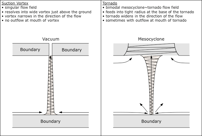
Note that if the general sense of the flow field is upward (as is the case in a tornado), all of the factors are mutually enhancing. The low pressure in the mesocyclone pulls air inward and upward. Existing momentum in another direction results in a cyclonic inflow, which resolves into a vortex. The reduced pressure in the vortex opens up a channel for the flow of an electric current. The current heats the air, increasing its buoyancy, which makes it rise faster, further reducing the pressure in the inflow. It also allows for the passage of more current. This interplay of electromagnetic and thermodynamic factors is called a "discharge vortex."
The amount of power involved in this positive feedback loop is non-trivial. The magnetic field generated by a tornado was measured at 1.5 × 10⁻⁸ teslas from a distance of 9.6 km away using a magnetometer.112 From this we can calculate the amps.
permeability of air = 4 π × 10−7 N/A2
amps = teslas × 2 π r / permeability
amps = (1.5 × 10−8 × 2 × 3.14 × 9600) / (4 × 3.14 × 10−7) = 720 A
720 amps of steady current, for the life of the tornado, seem a bit much, and that number has not been confirmed for any other storm. More conservative estimates of tornadic currents have been in the range of 100~250 amps.30,112,113,114 For now, we can use the lower of those numbers, just to show how previous researchers reached their conclusions, while in subsequent sections, it will be demonstrated that as little as 1 amp might suffice for an EF1 tornado. So with 100 amps of current, and guessing that the tornado was 300 m tall, and given an electric field of 5 kV/m,30,115,116 we can then calculate the watts.
volts = 300 m × 5,000 V/m = 1,500,000 V
watts = amps × volts = 100 × 1,500,000 = 150,000,000 W
150 million watts is greater than the 100 million watts that could be coming from latent heating (as calculated in the previous section), and way more power than would necessary to overcome 1 million watts of skin friction at the ground. Consequently, some researchers became convinced that the tornadic energy source had been identified.
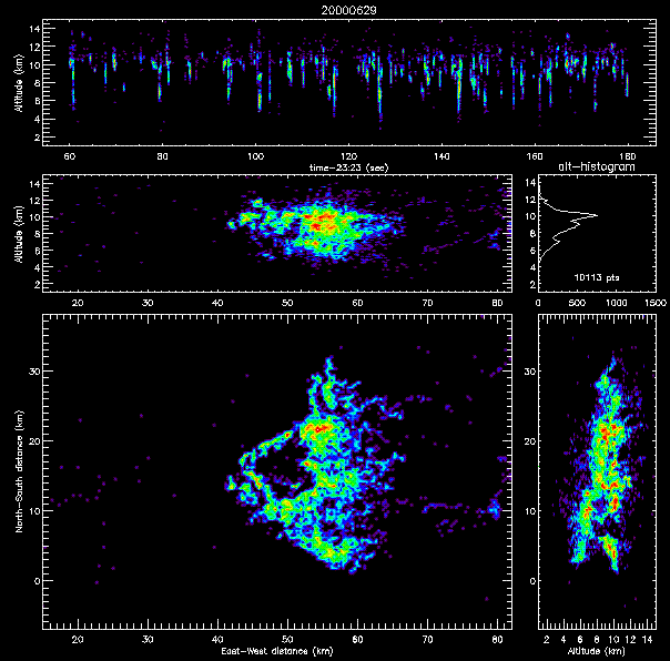
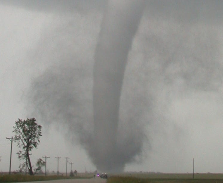
Critics of this theory have argued that tornadoes cannot possibly be electromagnetic, because there isn't enough electric field under a supercell for lightning, much less for the far more energetic tornado. While the electric field responsible for lightning is well above 10 kV/m, the electric field under a supercell is more like 5 kV/m.30,115,116 The reduced electrostatic potential results in a distinct reduction in lightning.117,118,119,120 This is known as the "lightning hole," and an example is clearly visible in Figure 72, where the hole was 9 km wide (roughly the width of the supercell itself). So there was almost no lightning under the main body of the supercell, but a ring of lightning around the edge, and a bit more on the downwind side. And it is within the lightning hole that the tornado appears. So tornadoes and lightning are mutually exclusive, and therefore, tornadoes and electromagnetism are mutually exclusive.
Figure 72. Lightning hole in 2 minutes of activity shortly before the formation of an F1 tornado near Goodland, KS, 2000-06-29, courtesy New Mexico Tech. (The large pane in the lower left is the plan view.)
The discharge vortex theory responds by saying that an inverse relationship proves that the two are indeed related, and since lightning is electromagnetic, tornadoes have to be electromagnetic as well (otherwise they wouldn't be mutually exclusive). And the nature of the relationship is that the tornado is continually draining electric charges from the cloud in a dark or glow discharge, preventing the build-up of the potential necessary for lightning. It's certainly true that a tornado is far more energetic than a single lightning strike, but the contention is that a tornado has all of the energy of all of the lightning strikes in a 9 km diameter. That balances the energy budget, and explains the lightning hole.
But the original question, concerning the concentration of energy release at the ground in a tornado, remains unanswered. The power from ohmic heating is quite respectable, but like latent heating, it is distributed throughout the full height of the tornado, while the heat build-up increases with altitude. Imagine a heating element 1 m wide, 1 km tall, and with 150 million watts of power running through it. Air near the ground is heated, so it rises. As it rises, it continues to be heated, so it rises faster. It achieves its highest temperature (and therefore its greatest buoyancy) at the top. This is precisely the behavior of a standard suction vortex, wherein the velocity increases with proximity to the source of the low pressure. So the discharge vortex theory doesn't explain the defining characteristic of a tornado, wherein the lowest pressure, tightest radius, and fastest wind speeds are at the ground, where the friction is the greatest.
Other EM theories have been proposed.97,114,121,122,123,124,125,126,127,128,129,130,131 But like the discharge vortex theory, none have answered the original question: what concentrates the release of energy at the lower boundary?
The key to sorting this out is in the anomalies. There are several, and if we do a thorough analysis, they will reveal the answer. Most tellingly, the electric current inside the tornado has been estimated by several methods to be in the range of 100~250 amps,30,112,113,114 but evidence of such a current going into the ground has never been found. 100~250 amps doesn't sound like a lot, especially when considering something as powerful as a tornado, so the significance of this is easy to miss. But an electric current passing through the air will find the nearest high-conductivity feature on the ground into which to flow. It could be a lightning rod, or exposed house wiring, or a tree, or a chain-link fence. If that feature offers more electrical resistance than a 25 mm copper cable, it will be charred or vaporized by the sustained 100+ amps. Yet of all the strange things that tornadoes have done, this is not one of them. In 2,000 years of tornado damage reports (including those predating bulldozers, when all of the rubble had to be sorted by hand), there has never been a report of selective charring or vaporization.
As both the presence of the current and the absence of evidence in the ground are irrefutable, there is really only one possibility — the current terminates in the air itself. In other words, the current is between two oppositely charged regions of the atmosphere, one inside the cloud and the other near the ground, and the low pressure inside the tornado serves as the conduit for the current. This means that there is a charge neutralization occurring near the ground, which is an energy conversion. As this is the only conversion that could be occurring near the ground, it needs to be fully investigated as the possible driving force in a tornado.
First we should identify the signs of the charges. We know that the air flowing into the tornado is clear, so it isn't bearing any water droplets or aerosols. Furthermore, relative humidity readings in the tornadic inflow are typically something like 20%,132 so all of the water is fully evaporated. Since molecular N2, O2, and H2O are not good at hosting net negative charges, it's reasonable to assume that any noticeable space charge would be positive. (This is confirmed by a variety of means in subsequent sections.)
If the air flowing into the tornado is positively charged, and it's getting neutralized by a current through the tornado, the cloud has to be negatively charged. This is confirmed by radar (and other data). The best radar reflector in the cloud is hail, which is also capable of the greatest negative charge densities, while rain is the 2nd best reflector and negative charge carrier. Hence what we see on radar corresponds roughly to negative charge densities.133,134,135 In Figure 37 we can see the dense precipitation in the hook echo 1 km above the ground, indicating the position of the main negative charge region. So the electric current in the tornado is from a negative charge in the cloud to a positive charge in the air below the cloud.
.png)
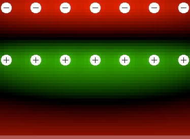
In addition to the electric field between the charges in the cloud and the air below it, there is another field to be considered. At the ground level, the charge aloft is positive. Due to the conductivity of the Earth, it gets an induced negative charge, resulting in a tripole field, as in Figure 73.
Figure 73. Potential gradients (ΔΦ) with a layer of negative charge on top, positive charge in the middle, and an induced negative charge in an otherwise neutral solid conductor at the bottom. Electrostatics applet by Paul Falstad.
With time, the positive layer will evolve into a bimodal form, with an increased charge density at the top, near the primary negative charge, and with another concentration at the bottom, near the induced negative charge in the Earth, as in Figure 74. As such, there are two possible stages in the development of an electric current from the cloud into the air below the cloud. The first is from the cloud into the screening layer just below the cloud, which might help the wall cloud get established. The second is from the cloud all of the way down to the layer clinging to the ground, which is responsible for the tornado.
Figure 74. Bimodal positive space charge between the cloud and the ground, with an electric current flowing through the tornado.

Given the current density, and assuming that the current is flowing into the air itself, if we know the charge density of the air, we can calculate how much charged air would have to be flowing into the tornado to absorb all of that current. Previous research estimated the number of charged particles in the tornadic inflow to be one part per billion (2.14 × 10¹⁴ charged particles/m3), and the charge per particle to be 3.2 × 10⁻¹⁷ C.128
space charge = 2.14 × 1014 × 3.2 × 10−17 = 6.8 × 10⁻³ C/m3
The numbers are realistic, but the researchers assumed that the charges would be borne by microscopic aerosols (Ø 0.02 µm), which as noted above does not agree with the typical relative humidity readings. If we assume that the charged particles are all molecular ions missing only one electron, a reasonable estimate would be one part per million.
molecules in a cubic meter of air = 1 × 10²³
one charged molecule per million = 1 × 10¹⁷ ions/m3
1 coulomb = 1.6 × 10¹⁹ electrons
space charge = (1 × 10¹⁷ ions/m3) / (1.6 × 10¹⁹ electrons/coulomb) = 6.25 × 10⁻³ C/m3
So this way, we get 6.25 × 10⁻³ C/m3, which agrees with the estimate of 6.8 × 10⁻³ C/m3 from previous research. So let's see how much air, at that charge density, it would take to absorb 100 amps of current.
at 6.25 × 10⁻³ C/m3, 1 coulomb = 1 / 6.25 × 10⁻³ m3 = 160 m3
1 amp = 1 coulomb / second
current = 100 amps = 100 C/s = 100 × 160 m3/s = 16,000 m3/s
With that as the volume, we can then determine the horizontal velocity of the inflow.
depth of inflow layer = 1 m
circumference of tornado 100 m wide = 314 m
cylindrical surface of vortex mouth = 314 m2
velocity of inflow = 16,000 m3/s / 314 m2 = 50.96 m/s
50.96 m/s is just barely into the EF2 range, which would seem appropriate for an electric current at the low end of the 100~250 amp estimates.
So we have a main negative charge region in the cloud that supplies 100 amps of current through the tornado and into 16,000 m3/s of positively charged air clinging to an induced opposite charge in the ground. How does that account for the behaviors of a tornado?
Let's do a thought experiment on a smaller scale. Consider standing on a steel deck, ankle deep in a pool of positively charged air, which induces an opposite charge in the steel, resulting in an electrostatic attraction that will hold the air down to the deck. Let's further suppose that the charged air is warm enough that it would rise, except for the electric force pulling it down to the deck.
Now hold a fan at arm's length, point the direction of the flow upward, and turn it on. The low pressure below the fan will pull in air, all except for the charged air being held down to the deck by the electric force. In other words, you won't get a vortex that latches onto the solid boundary, like a tornado. So shut off the fan and set it aside.
Now wheel in a DC welding machine. After setting the polarity to emit electrons, grab the whip and point it at the deck. With the whip 1 m above the deck, dial up something like 20 kV, which will be enough to get a slow migration of electrons through the air, attracted to the positive charge in the air above the deck, but not enough to get a glow discharge, much less an arc discharge. (If anybody asks what you intend to do with only 20 kV of potential through 1 m of air, just tell them that you're doing a thought experiment and to leave you alone.)
As the electrons pass through the air on their way to the positive charge below, they cause resistive heating, which initiates a slight updraft, starting at the whip itself, and extending downward. The hotter air is a slightly better conductor, so past this point, the continued flow of electrons will prefer the existing channel, keeping the current consolidated. When the electrons finally get to the bottom, they neutralize the positive charge in the air. Electrostatic pressure from the surrounding air still clinging to the deck pushes the neutral air "out of the way," which just happens to push it upward into the resistive heating updraft.
Once the first parcel of charged air is neutralized and joins the updraft, neighboring parcels of charged air flow inward to take its place. They pick up a little bit of frictional heat on the way due to their proximity to the lower boundary, but the charged air flows easily because of its low viscosity. When those parcels of air get to the base of the updraft, their charges are neutralized, so they join the updraft a tad more vigorously.
The slightly warmer air in the updraft will allow the electric current to flow more easily, meaning more electrons making it to the base of the updraft, where they can neutralize more positively charged air. The faster flow into the updraft means more frictional heating, which increases the buoyancy of the air, which means that once the charge is neutralized, it will rise more vigorously.
If the inflow is slightly asymmetrical, it will switch from a radial to a cyclonic inflow pattern, instantiating a vortex. The reduced pressure inside the vortex (due to the centrifugal force from the rotation) will further decrease the electrical resistance of the air, resulting is a fully consolidated flow of electrons through the vortex. The increased current density then becomes capable of neutralizing even more positively charged air, and the vortex becomes robust.
Now reach over and grab the fan again, and hold it above the welder's whip, pointing upward. The updraft from the resistive heating will then feed straight into the low pressure of the fan. The fan will still be able to pull air from all around, but the pressure at the top of the vortex will be decreased, and this drop in pressure will be felt throughout the entire vortex, increasing the inflow and updraft speeds.
Now we can consider how all of these factors interact in a real tornado. There is an updraft in the cloud pulling in air from all around. This will not create a vortex with the destructive power of a tornado on the ground. But it will open up a conduit for the flow of electricity. Ohmic heating then creates a channel of air below the cloud that rises faster. If the air flowing into this channel has any angular momentum, a vortex will form, which will project along the centerline of the inflow until it hits a boundary (i.e., the surface of the Earth). The reduced pressure inside the vortex consolidates the electric current, and the vortex becomes more robust. With the vortex truncated at the lower boundary, the pressure equalizes throughout the entire vortex, and the effects of the low pressure within the cloud, plus the enhanced updraft due to ohmic heating, are felt at the ground. If this drops the pressure enough to create condensation, the release of latent heat adds more power. And the inflow picks up a little bit of frictional heat as it moves along the ground, until its charge is neutralized inside the vortex and it is free to ascend.
So we have plenty of energy sources. But we should remember that the major energy sources (i.e., the low pressure aloft plus the ohmic and latent heating inside the tornado) were shown in previous sections to be incapable of developing an extreme low pressure at the ground level, as these conversions occur through the entire height of the tornado. The force present only at the ground is the electrostatic attraction of the charged inflow to an induced charge in the Earth, and the only conversion only at the ground is the neutralization of that space charge, which releases the small thermal potential developed in the inflow by frictional heating. In what sense does that conversion account for the concentration of energy at the base of the tornado?
The significance of the inflow clinging to the ground is that it pulls the vortex throat right down to the ground, eliminating the "mouth regime" typical for a suction vortex. All other factors being the same, boundary separation occurs early, before the air achieves peak speed, and the spiraling inflow is gracefully transformed into a helical updraft, without any sharp corners in the airflow. But if boundary separation is artificially prevented by the electric force, the air stays on the ground, picking up additional Rankine acceleration, and additional frictional heating. Once the electric charges in the air are neutralized, all of the thermal potential developed by the skin friction is released. This means that in addition to the low pressure inside the vortex (due to the low pressure aloft, as well as the latent & ohmic heating inside the vortex), there is an extra boost in the updraft when it is suddenly freed from its electrostatic attraction to the ground. That extra boost is then responsible for the extreme low pressure at the mouth of the vortex, directly on the ground.
So in a tornadic vortex, the pressure does not decrease with proximity to the source of the low pressure. Rather, the "pipe" is sealed from top to bottom, and the pressure equalizes throughout. The one conversion that is occurring only at the ground then results in an even lower pressure there, where the space charge in the inflow is neutralized, and its thermal potential is released. And thus we can now account for the distinctive characteristics of a tornado, that the lowest pressure, tightest radius, and fastest wind speeds are at the ground, where the friction is the greatest.
This means that the minimum conditions for a tornadic vortex are:
a liquid or solid conductor at the bottom (i.e., the Earth),
positively charged air clinging to the ground,
an abundance of negative ions aloft, and
sufficient voltage (and/or insufficient resistance) enabling an electric current.
Note that this model does not require that there be a low pressure aloft, much less a rotating updraft. The standard model considers the tornado to be a simple projection of the mesocyclone. But that can be disproved in many ways. First, some of the most powerful mesocyclones on record did not produce tornadoes.98,99 Second, 20% of all tornadoes descend from thunderstorms that aren't rotating.54 Third, if a tornado does descend from a mesocyclone, the rotation rate does not fare evenly from the one to the other — the tornado rotates at a rate that is independent from the rotation of the mesocyclone. Lastly, if tornadoes were suction vortexes, their behavior at the lower boundary would be different. These facts will always be enigmatic within the standard model. In fluid dynamics, the distinctive characteristics of tornadic vortexes simply shouldn't be possible. Only with the methods of EMHD can we see how a combination of electromagnetic and thermodynamic factors can produce such a phenomenon.
Also note that this model does have an electric current inside the tornado, but it is not between the cloud and the ground as researchers once believed, and which was demonstrated to be inconsistent with the evidence (and the lack thereof). Rather, the current is between the cloud and the charged air above the ground. The ground is only a factor because it can support an induced opposite charge and thereby attract charged air to it, and because it introduces friction that pre-heats the air flowing into the vortex.
To form a complete hypothesis, there is one more issue that must be addressed. If the tornadic inflow is picking up frictional heat as it travels along the ground, it is also gaining buoyancy. The EMHD model contends that this buoyancy is the energy that is released at the base of the vortex when the inflow's charge is neutralized. Prior to entering the vortex, the air is buoyant enough to rise, but it cannot, as the positive charge in the air has induced a negative charge in the Earth, and the electric force is offsetting the thermal buoyancy. So we need to confirm that the electric force is more powerful than the buoyancy.
Estimates for the amount of power expended on the ground in a tornado range from 5 million watts for an EF1 to 5 billion watts for an EF5. So let's run the numbers for an EF1. First we'll consider the force of the electric field that is pulling the air toward the ground.
space charge = 6.25 × 10⁻³ C/m3
electric field = 5 kV/m
newtons = coulombs × electric field = 6.25 × 10−3 × 5,000 = 31.25 N/m3
Next we'll assume an inflow rate of 1,000 m3/s for an EF1, and apply 5 MW of heat to it, and see what that does to the temperature. Raising the temperature of 1 m3 of air by 1 °C in 1 second requires approximately 1,340 watts.
watts per m3 of air = 5 MW / 1,000 m3/s = 5,000 W·m3·s
temperature difference = 5,000 W·m3·s / 1,340 W·°C·m3·s = 3.73 °C
From the temperature difference, we can calculate the buoyancy.
mass of air at STP = 1.2 kg/m3
newtons = kilograms / 0.101971621
gravitational force at STP = 1.2 / 0.101971621 = 11.77 N/m3
standard temperature = 15.6 °C = 288.75 K
after frictional heating = 288.75 K + 3.73 = 292.48 K
temperature ratio = 288.75 / 292.48 = 0.987246991
gravitational force after heating = 11.77 N/m3 × 0.987246991 = 11.62 N/m3
buoyancy = 11.77 N/m3 − 11.62 N/m3 = 0.15 N/m3
With a downward electric force of 31.25 N/m3, and an upward buoyancy of only 0.15 N/m3, that's 208 times more electric force than buoyancy. With 2 orders of magnitude less electric force, the air would still stay near the ground until the electric charges are neutralized. So we'll consider 6.25 × 10⁻⁵ C/m3 to be the minimum space charge necessary to hold the air down as it is heated by friction.
Note that this also drops the minimum neutralizing current, from 100 amps, down to 1 amp, at least for an EF1 tornado. 1 amp of current can easily be supplied by a thunderstorm that is only 2 km in diameter.76 (A typical lightning strike transfers 20 coulombs, and a typical strike rate is two per minute. 20 C / 30 s = 0.66 amps of steady current, so we know that thunderstorms can manufacture charges that fast.) A supercell, with a diameter of 10 km, and therefore with 25 times the volume, typically issues 25 times the lightning, or roughly one strike per second,117,118,119,120 meaning 25 amps. So we have plenty of current.
Also note that dropping the current down to 1 amp also drops the ohmic heating, from the 150 million watts estimated in the section entitled "Electric Tornadoes?", to 1.5 million watts, making it far less significant than the 100 million watts that was (generously) estimated for latent heating in the section entitled "Atmospheric Vortexes". Regardless, there is still plenty of power to drive the updraft.
Taking this analysis as the working hypothesis, subsequent sections will make a comprehensive review of the essential types of field and laboratory data available, and develop this into a complete theory.
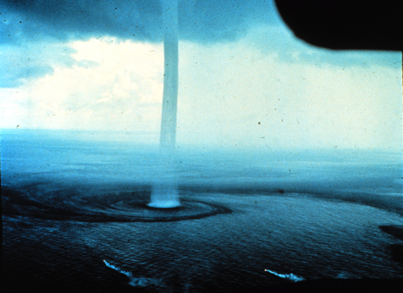
Central to the present hypothesis is the assertion that the tornadic inflow is attracted to the Earth by the electric force, and can only develop vertical velocity once its charge has been neutralized by the electric current inside the vortex. There is, in fact, evidence of just such an attraction of the inflow to the Earth. It's most obvious when the cyclonic inflow inscribes a pattern on the water.
Figure 75. Waterspout with banded inflow, courtesy NWS. Darker water means faster winds.
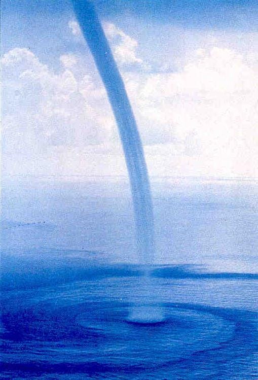
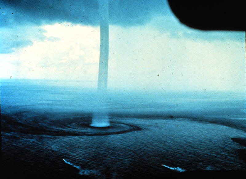
Figure 76. Waterspout with banded inflow off the Florida Keys, 1969-09-10, credit Joseph Golden, courtesy NOAA. Notice the flares indicating that the prevailing surface winds are not part of the inflow.
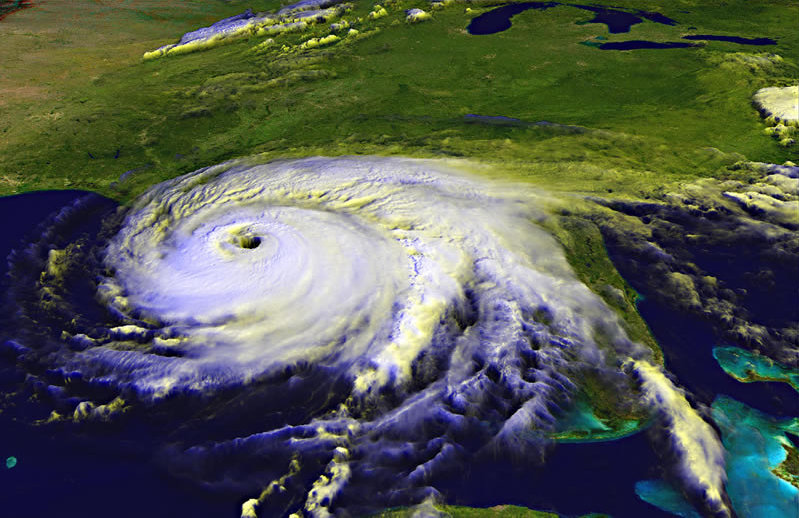
The cyclonic pattern makes sense, as this is what we would expect for any suction vortex, such as a tropical cyclone (as in Figure 39). But on closer scrutiny, there are some things about these photographs that really don't make sense if these are just suction vortexes.
To start, we can clearly see a distinct channel of darker water that spirals inward. Since darker water means faster winds, this reveals a channel of air that is moving much faster than the surrounding air. In fact, the flares in Figure 76 reveal that the air outside of the channel isn't even part of the inflow. This is definitely not what we would expect in a suction vortex.
In fluid dynamics, channeling is evidence of differences in viscosity. If all of the air has the same viscosity, it is all subjected to the same friction. Any air moving faster will experience more friction, so we expect a self-regulated consistency in the inflowing speed. But if some of the air has a lower viscosity, it will experience less friction, and therefore it will tunnel through the higher-viscosity air. Put more mechanistically, starting from the low pressure at the mouth of the vortex, ordinarily air would flow in from all directions, but if some of it has a lower viscosity, that air will flow faster in response to the low pressure. When that parcel shifts inward, the low pressure left behind it will be filled by air from all directions, unless some of that air has a lower viscosity, in which case the channel extends even further away. In this way, the inflow channel can extend all of the way from the vortex to the source of the lower-viscosity air (discussed in the section entitled "Rear Flank Downdrafts").
Normally there are only two factors responsible for the viscosity of air: temperature and humidity. Of the two, temperature is the more significant.
Table 2. Kinematic
Viscosity of Air
(× 10−5 m2/s)

But within the relevant ranges of temperature and humidity, we only get a 6% difference in viscosity, and we're seeing much more than a 6% difference in velocity. This rules out a fluid dynamics explanation, so the only possibility is that this is one of the effects of the electric force. And in fact, if the air is charged, electrostatic repulsion within the air will prevent the particle collisions that instantiate friction, thereby reducing the viscosity.25,26,27 At the macroscopic level, electrostatic repulsion discourages the low and high pressures inherent in turbulent flows, thereby encouraging the flow to remain laminar well above the threshold for turbulence, with the effect of increasing the speed of the flow.
Far more significantly, this electrostatic reduction in viscosity also explains why charged air, attracted to an induced opposite charge at the surface of the Earth, can flow into the vortex faster than neutral air just above it. In other words, in top view we see a discrete inflow channel that can only be explained as charged air tunneling through neutral air, and in elevation view we see the lowest layer of air skidding along the surface to get into the vortex (as represented schematically in Figure 71), which again can only be explained as charged air tunneling through neutral air. The difference is that the elevation view is a lot harder to explain. A relatively small difference in viscosity can result in a jet of air channeling through other air, but at a boundary, skin friction increases with the square of the velocity, meaning that the viscosity difference has to be enormous for the boundary layer to flow faster.
Figure 77. Normal versus tornadic boundary layers.

To highlight the point, it's instructive to note that fluid dynamics does have a way of getting a fluid to move faster at a boundary, but only if there are actually two fluids present, where the fluid with the lower viscosity is in contact with the boundary, as in Figure 78. Even though the friction is greater at the lower boundary, the milk will flow faster than the honey due to its lower viscosity, and the milk will channel through the honey to satisfy the low pressure.
Figure 78. Suction vortex in two fluids.

Two-fluid simulations are sometimes used to study tornadic vortexes, as they have a couple of properties in common with tornadoes, and that are impossible to get otherwise.136 First, the vortex only pulls in more fluid at the lower boundary, and second, the inflow travels along the lower boundary, even if it has to travel a long way. The reason why two-fluid simulations aren't considered to be realistic is that it shouldn't be possible to develop such substantial viscosity differences in the air. As there is no doubt that tornadoes exhibit two-fluid behaviors, and as temperature and humidity combined cannot account for the difference in viscosity, the only possibility is that the "lower fluid" is a layer of charged air.
Back to the cyclonic pattern in Figures 75 and 76, the EMHD model states that the space charge inside the inflow channel has to be at least 6.25 × 10⁻⁵ C/m3 if it is to overpower the buoyancy generated by frictional heating. Previous research has found a correlation between electric fields and the speed of the tornadic inflow,30 suggesting that they detected an inflow channel. But the increase in electric field was attributed to triboelectric charging in the particulate matter that was creeping or saltating along the ground. The particulate matter itself was not studied — it was merely assumed that any difference in electric field that was directly proportional to air speed had to be due to static electricity, because until now, no one has proposed that the air itself is charged. It will take a space charge study to resolve the issue.
Also note that while conventional modeling of a tornado uses the Rankine formulas,137,138 which assume that the flow field is axisymmetric, the channels in Figures 75 and 76 are certainly not. The significance is that in a discrete inflow channel, the velocity does not decrease with distance from the vortex — it is the same, from the source of the channel to the vortex wall. This means that velocities outside of the vortex are underestimated by Rankine assumptions, and the difference might account for at least some of the unexplained destructive power of tornadoes outside of the vortex wall.
While 6.25 × 10⁻⁵ C/m3 is only a moderate space charge by electrostatic standards, and is less than the charge produced by household ionizing air purifiers, it is nevertheless far above the normal atmospheric charge density. This means that something had to produce it, and a complete theory has to identify the source of this charged air.
The EMHD model of the mesocyclone offers the first possibility, that there is a positive double-layer paralleling the main negative charge stream. If the mesocyclone descends, this double-layer is squashed against the ground, forming the forward flank downdraft (FFD).
Figure 79. Relationship of forward flank downdraft to precipitation core.

If the FFD is positively charged, it makes sense that it is a vigorous downdraft, and yet it typically only yields light precipitation, while the main rain area is between the FFD and the mesocyclone, where the downdraft is weaker. (See Figure 80.) All other factors being the same, we'd expect the fastest downdrafts to bear the most precipitation, because of precipitation loading (i.e., the additional gravitational force from the rain or hail), and because of the availability of liquid water to sustain evaporative cooling as the air descends. So the main rain area should have the fastest downdraft, and the FFD should be weaker. Since it's actually the other way around, we have an anomaly to explain, and the likeliest explanation is that the FFD is positively charged. As the air descends, evaporation reduces the size of a solid or liquid water particle. If it is charged, the charge density increases. If it hits the Rayleigh limit, the particle will break apart due to electrostatic repulsion.139 Hence a positive charge encourages evaporation, and a positively charged downdraft is subject to more evaporative cooling than a neutral or negative downdraft, and this makes it fall faster.
Once the FFD hits the ground, the outflow expands in all directions, and there is evidence of charged air flowing from the FFD all of the way back to the mesocyclone, against the prevailing surface-level winds. So the FFD does make a contribution to the tornadic inflow.
But recent research suggests that the larger body of air flowing into the tornado comes from the rear flank downdraft (RFD), so we'll focus on this instead, and see if we can develop a reasonable estimate of its charge density.
The RFD is a sustained dry downdraft, outside the cloud, on the upwind side of the storm.132,140 Its presence in tornadic storms is so consistent that it is considered to be a causal factor in tornadogenesis, though "causal" is a loose term in this context, since no one can explain why a downdraft, upwind of the mesocyclone, would encourage tornadogenesis. This air invariably gets drawn into the mesocyclone,35,141,142,143,144 and though there are "cold RFDs" and "warm RFDs," they are generally a couple of degrees (Celsius) cooler than the surface-level air. So they should reduce the force of the mesocyclone, and that would tend to discourage tornadogenesis.
Figure 80. Plan view of supercell, courtesy NWS, redrawn by Vanessa Ezekowitz.

Furthermore, thermodynamics can't even explain what causes the RFD itself. If it was a wet downdraft, then it would be cold, dense air falling because of evaporative cooling, the way normal downdrafts are created. But this does not appear to be the case. There is certainly a downdraft caused by precipitation falling out of the back-sheared anvil, but because of wind shear, this air shouldn't fall straight to the ground. Rather, it should get blown around the updraft, and hit the ground between the mesocyclone and the forward flank downdraft. This has led researchers to believe that the RFD has to originate from a lower altitude in order to hit the ground upwind of the storm. Below the anvil, the closest that we could come to a wet downdraft, upwind of the storm, would be if shearing dry air mixed with precipitation-bearing air in the cloud itself, causing the precipitation to evaporate, and creating a downdraft. This is theoretically possible, but a downdraft falling at 50 m/s, when it began its descent only a couple of kilometers above the surface, would only be possible if the air had become completely saturated with water vapor, creating far colder and denser air than has been observed. Actual RFD relative humidity readings are more like 20%, with temperatures near those of the surface-level air.132 Such air simply has no right to be a downdraft.
Some of the literature suggests that the RFD is a result of high pressure on the upwind side of the storm, where shearing mid-level winds collide with the updraft. But the lateral motion at the relevant altitudes is roughly 20 m/s, while the RFD falls at roughly 50 m/s. Even if the cloud was an impenetrable boundary of that shape, it would not create deflected speeds faster than the approaching speeds. And clouds are certainly not impenetrable boundaries in the thermodynamic model. Besides, if shearing mid-level winds collide with an updraft, there will be a high pressure. But there will be two net effects: the updraft will get tilted in the direction of the mid-level winds, and the mid-level winds will get deflected in the direction of the updraft. In other words, the result will be the vector product of the two motions. This will not create a downdraft — it will create entrainment into the updraft.
Mechanistically speaking, the RFD is hard to explain, and it has proved difficult to simulate with thermodynamic modeling.132 This means that other forces are present.
Positively charged precipitation falling out of the back-sheared anvil will indeed initiate a downdraft, which itself will be positively charged. Due to wind shear, we would expect this downdraft to wrap around the storm, and merge with the forward flank downdraft. But if it is positively charged, it will be repelled from the massive positive charge in the main body of the anvil, and it will be attracted to the negative charge induced in the Earth by it. This gives it the force necessary to ignore the shearing mid-level winds, and to fall straight to the ground. (As outlandish as this might seem, evidence of the jet stream getting forced all of the way to the ground was collected during a tornado in Leamington, Ontario on June 6, 2010.145)
Figure 81. Hypothesized origin of the rear flank downdraft.

The ultimate speed of the RFD is obviously not a simple function of evaporative cooling, since it isn't substantially cooler than the surrounding air. Only the EMHD model identifies ample energy sources, in the correct form, to account for a 50 m/s downdraft upwind of the storm. A 50 m/s upper-level jet gets deflected down by evaporative cooling from virga falling out of the back-sheared anvil. The downdraft is also accelerated down by electrostatic repulsion from the anvil, and it is pulled down by its attraction to an induced opposite charge in the ground. And though the RFD hits the ground with a lot of force, it hits only 1 km from the main updraft in the storm, so the low pressure at the base of the mesocyclone absorbs the high pressure. Hence the RFD has pushes and pulls all of the way through its trek, from its origin as an upper-level jet to its entrainment into the mesocyclone.
Note that the furl in the "back-sheared" anvil is commonly considered to be the result of the "collision" between the jet stream and the expanding anvil. Actually, there's no collision. Evaporative cooling under the anvil does all of the work in deflecting the jet stream downward, and the anvil is actually being sucked into the void left by the diverted jet.
So if the evaporative cooling is that powerful, why isn't the RFD as cold as a normal downdraft (at least 10 °C below ambient)? The reason is that the RFD only gets one dose of hydrometeors, which completely evaporate within the first couple of kilometers below the anvil. This is the source of the 20% RH readings in the RFD. This also accounts for temperatures near those of the surface air. Jet stream air, if mechanically forced down to the ground, would actually be far warmer than the surface air, due to the compression. So some evaporative cooling is occurring. But for the RFD to be a wet downdraft hitting the ground, with 100% RH at 10 °C or more below ambient, there would have to be an over-abundance of hydrometeors that could sustain the evaporative cooling all of the way down. As the downdraft falls, the ambient pressure increases, which raises the temperature, creating the gap between the temperature and the dew point into which the excess hydrometeors can evaporate. If sufficient liquid/solid water is present, evaporative cooling continues. Otherwise, a 100% RH under the anvil results in 20% RH at the ground, with temperatures at or near ambient.
Is the RFD capable of supplying air with a minimum space charge of 6.25 × 10⁻⁵ C/m3, as estimated in the section entitled "A New Hypothesis"?
If the tornadic inflow comes from the RFD, which originates as an upper-level jet stream, we should start our assessment with the upper-level jet. This is already positively charged, as positive charge increases with altitude, but this charge is not significant for our purposes. In the fair weather conditions upwind of an isolated thunderstorm, the upper-level jet only has 1 × 10¹⁰ ions/m3 (producing 6.25 × 10⁻¹⁰ C/m3),93,146 which is 5 orders of magnitude shy.
The next source of charge will be virga falling out of the back-sheared anvil. Typical charge densities in the cloud inferred from electric field measurements are ≤ 1 × 10⁻⁹ C/m3,21,147 so we might guess that this is the charge of the downdraft under the back-sheared anvil. But this is still 4 orders of magnitude less than the minimum of 6.25 × 10⁻⁵ C/m3 at the ground level.
If the positively charged anvil of one thunderstorm is overhanging the updraft of another thunderstorm, the upper-level inflow will be pre-charged.63 But even if we double the charge density in the anvil, and add that to the fair weather charge of the upper-level jet, we still only have 2.625 × 10⁻⁹ C/m3, which is still 4 orders of magnitude too little.
Between the back-sheared anvil and the ground, we can expect the charge density of the RFD to increase. The parcels of air that absorb the most virga will undergo the most evaporative cooling, so they will fall the fastest. Because the virga is charged, the fastest-falling parcels will also have the highest charge density. The charges themselves will accelerate the descent, as repulsion from the anvil and attraction to the induced opposite charge in the ground will motivate the flow. Also, the greater charge density will reduce the viscosity and prevent the transition to a turbulent flow,25,26,27 further increasing the velocity. In Figure 75 we're seeing roughly an order of magnitude of speed increase that can only be attributed to the turbulence threshold being raised by the space charge. So we can guess that all of the factors in this paragraph added together will increase the charge density in the RFD by an order of magnitude, meaning that the discrepancy is now 3 orders of magnitude, not 4.
At the ground, the RFD expands outward into the flow field of the tornado. Here again we can expect a 10x increase in speed due to the reduction in viscosity and in turbulence due to electric charges (as in Figure 75), so nominally (and perhaps generously), the discrepancy comes down to 2 orders of magnitude.
And there is one more factor that needs to be considered. Where the RFD hits the ground, there is a turbulent flow in the presence of an electric field. Since the forces that determine which way a parcel of air will go in a turbulent environment are subtle, any other force present will have a dramatic effect. Hence we can expect the electric force to sort the parcels on the basis of charge, resulting in a far greater charge density near the ground.
How much greater? We wouldn't attempt a numeric answer to such a question, as turbulent flows are tough to predict — only field studies return reliable descriptions of such behaviors. Unfortunately for the present research, no one thus far has seen the justification to attempt the logistical difficulties (and the dangers) of getting space charge data from inside the tornadic inflow, because no one previously assigned any significance to them. This leaves a conspicuous void in the middle of the calculations. We know that the tornadic inflow sticks to the ground, despite the friction and the buoyancy that results from it, proving that another force is present. In the atmosphere, that "other force" can only be the electric force. We know that there is an electric current inside the tornado, and that it isn't going into the ground, so it has to be terminating in the air itself. This would only be possible if the air itself is charged. The current density and the volume of the inflow match, assuming a 1 part per million space charge. Two orders of magnitude less space charge would be sufficient to overpower the buoyancy created by frictional heating, accounting for the distinctive adherence of the tornadic inflow to the ground. So all of the pieces are fitting together, and the only one that's missing is the direct measurement to confirm that particle sorting due to turbulence between the RFD core and the tornado increases the charge density near the ground by 2 orders of magnitude.
Future research will, of course, answer all of the questions. In the meantime, the only way to proceed is to see if we can marshal the rest of the anomalies in the problem domain with an assumption that the proposed charge densities are present. In other words, we can check this hypothesis against all of the available data, even if we cannot check it against all of the possible data. If full consistency with existing data can be demonstrated within a plausible hypothesis, it will be time to seek the make/break field data that have not been collected yet.
So the EMHD model asserts that if the jet stream gets forced to the ground, hitting only 1 km from the powerful updraft inside a mesocyclone, the air will be drawn inward, but instead of curving upward as it goes, it will cling to the ground because of an induced electrostatic potential, of sufficient force to keep the air flowing along the ground, even as frictional heat increases the buoyancy well beyond the threshold for an updraft. Once inside the tornado, an electric current neutralizes the charges keeping the air down, thereby releasing the thermal potential in the air, resulting in a vigorous updraft. The updraft provides an outlet for the air flowing along the ground, enabling a continuous flow, from the high pressure at the base of the RFD, to the low pressure at the base of the tornado. The difference between the lines of motion predicted by fluid dynamics and the actual path followed along the ground constitutes the potential energy that is released at the base of the vortex.
Figure 82. Tornadic potential energy.

Lastly, we should consider the implications of these contentions for short-term tornado forecasting. If the RFD is a key ingredient in tornadogenesis, and if it is virga falling out of the anvil that initiates the RFD, then the jet stream and the back-sheared anvil deserve closer attention in estimating the probability of tornadogenesis. In these terms, it makes sense that the more severe the thunderstorm, the greater the chance of a tornado — only an extremely powerful updraft will be capable of setting up the back-sheared anvil that can then initiate the RFD. But it will also take powerful upper-level winds to tilt the storm such that the FFD doesn't undercut the updraft. Such might be the rare combination of extreme-range factors that enable these catastrophes. The significance here is that the back-sheared anvil is an easy feature to detect, visually as well as with radar, and from a great distance away. The RFD, being a dry downdraft, is invisible by both of those methods.
At this point, the core of the EMHD model of mesocyclones and tornadoes, and of the positively charged tornadic inflow that comes from outside the mesocyclone, is essentially complete. We shall now apply this model to the broadest possible range of tornadic phenomena, to see how the model stands up. The first test is to see if we can at last explain, in mechanistic terms, the classic form of the tornado, with the tightest radius at the base, which then expands in the direction of the flow.
Figure 83. Tornado in Union City, OK, 1973-05-24, courtesy NOAA Photo Library.
Figure 84. Wedge tornado (1 km wide at base) in Jordan, IA, 1976-06-13, courtesy Iowa State University.

In fluid dynamics, a "condensation funnel" is a well-understood phenomenon. The lines of motion in a standard suction vortex converge as they approach the source of the low pressure. (See Figures 60~64.) Away from the source, the low pressure relaxes. This means that lines of equal pressure inside the vortex slowly taper to a point away from the source of the low pressure. At any given relative humidity, one of these lines represents the pressure at which water molecules condense. At a large enough scale, the condensation will be visible, and the vortex will appear to expand in the direction of the flow, even as the lines of motion converge.
%202.jpg)
%207.jpg)
For meteorologists, thinking of the tornado as a condensation funnel inside a mesocyclonic vortex seems to be an adequate description. But this is fundamentally incorrect.
First, the mesocyclone and the tornado are actually two different flow fields, with stationary air in-between. (See Figure 71.) Only in the most extreme cases does the mesocyclonic flow field extend all of the way to the ground, but even then, there are distinct differences between the larger, slower mesocyclonic inflow and the smaller but faster tornadic inflow. (These details are discussed in the section entitled "Eccentric Sub-vortexes".) For the tornado to actually be the core of the mesocyclonic vortex, air speeds would have to start at 0 at the center, increase linearly to the maximum in the wall of the mesocyclone, and then decrease hyperbolically outside the wall. Yet the tornado rotates faster than the surrounding mesocyclonic inflow, meaning that it has to be a different vortex.
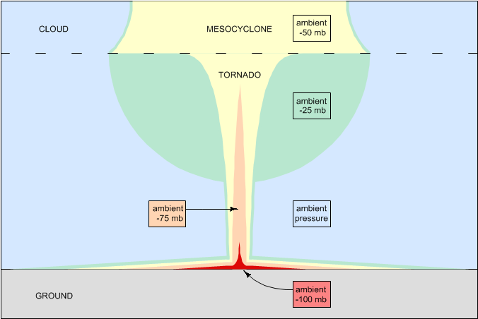
More problematic is that the lowest pressure is actually at the ground, and the low pressure relaxes in the direction of the flow.102,103,148,149 This means that the taper in the lines of equal pressure points upward. (See Figure 85.) In no sense does the visible aspect of the tornado reveal the isobars in the mesocyclonic flow field.
Figure 85. Mesocyclonic/tornadic pressure gradients.

The visible aspect of the tornado actually reveals simply the lines of motion, and these expand in the direction of the flow because the low pressure is relaxing (meaning less centripetal force). There is also sometimes a distinct flare at the top of the tornado where it merges with the mesocyclone, indicating that there is yet another change in the balance of centripetal and centrifugal forces in the tornado. (See Figure 86.) In this case, it is a reduction in the centripetal force supplied from outside the tornado, as a consequence of the decreasing pressure in the mesocyclonic flow field, that further increases the radius of the tornado.
Figure 86. Tornado near Bandar Lengeh, Iran, 2008-11-23, courtesy YouTube.

The base of a tornado is not always visible, and damaging or even deadly winds can occur when there is no other indication that a tornado is present at the ground level.150 The lack of condensation in the presence of an extreme low pressure is, of course, not what we would expect. There wouldn't be a thunderstorm if it were not for the moist air in the lower troposphere. And if there is a humidity gradient, we would expect the most humid air to be closest to the surface of the Earth, since it will be the coolest (and therefore the densest) air in the gradient. Especially in vortexes over the ocean, we would expect the humidity at the surface to be near 100%. Since tornadoes only pull in air from the surface, and since the pressure inside a tornado is lower than that inside a tropical cyclone,102,103,148,149 there should be no way that a tornado could form without causing condensation at the surface. Yet tornadoes without condensation at the surface are common, especially over the ocean. (See Figures 87~89.)
Figure 87. Tornado in Lombok, Indonesia, 2007-12-29, courtesy Fadil Basymeleh.
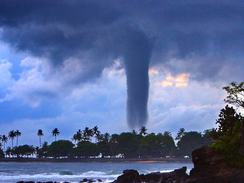
Figure 88. Waterspout near Oran, Algeria, 2007-10-30, courtesy Nassimatique.
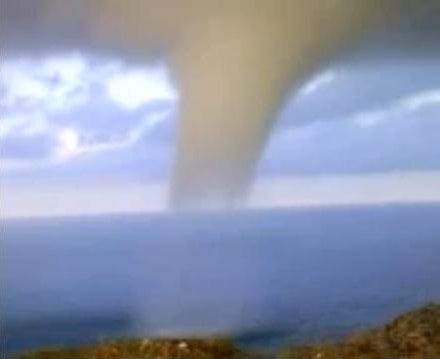
Figure 89. Waterspout off the coast of Brach, Croatia, 2006-08-04, courtesy D. J. Malden.

The standard model explains that such tornadoes are being fed by warm, dry air (such as from the RFD) that will not yield condensation even in the extreme low pressure at the base of the tornado.132,140 The EMHD model agrees, and goes on to say that the air is also positively charged. The positive charge reduces the chance of condensation, because the electrons necessary for covalent bonding are not present. Also, the water molecules might be so highly charged that the electrostatic repulsion between them is further discouraging condensation.22
But both models then have an even tougher question to answer. How does condensation form as the air ascends? Tornadoes only pull in air at the surface,151 so this is not evidence of a new source of moisture. The fastest wind speeds are nearest the surface,152,153,154,155 so there isn't any increase in tangential velocity that could drop the pressure and cause condensation. The lowest pressure in a tornado is at the surface,102,103,148,149 and from there the low pressure relaxes. If there isn't any condensation in the extreme low pressure at the surface, there shouldn't be any condensation anywhere in the tornado.
Only the EMHD model can explain this. If the tornadic inflow is positively charged, its water vapor will not condense until the charge is neutralized. There is certainly no absence of negative charge inside the cloud, and there is well-known direct evidence of an electric current inside tornadoes, which has been estimated at 100~250 amps.30,112,113,114 The electrons in such a current will eliminate the electrostatic repulsion between positively charged water molecules, and make covalent bonding possible. This enables the condensation of the water vapor even as the low pressure relaxes.
We should also observe that the "condensation funnels" are not tapering to a point. In fact, there isn't any condensation in the core of the vortexes — the condensation is all in the vortex wall. This is yet another indication that the standard fluid dynamic framework is unprepared to deliver an accurate description of these vortexes. The most likely cause for condensation in the vortex wall, and not in the core, is that the source of the neutralizing electrons is the negatively charged precipitation in the hook echo, which forms a sheath around the updraft. So the neutralization begins in a cylindrical form at the mesocyclone/tornado interface. From there, the electrons are attracted to the positive charge clinging to the lower boundary, which is by no means only within the vortex. Hence the electrons flow through the conductivity in the water vapor that has already condensed in the upper vortex wall to the truncation point, and then they flow straight down from there, never converging on the centerline.
In the preparation of this paper, two cases were found in which condensation occurred only at the surface, but these appear to be exceptions that prove the rule. First, see Figure 90. A dust sheath forms on the ground, and the video briefly pans upward to show the rope-like condensation funnel coming down from the cloud. But the rotation at the surface doesn't last long, and the dust sheath starts to fall apart. Look closely at the very end of the video — a bunch of condensation forms at the surface. Ordinarily, more condensation means lower pressure, and this would tend to indicate that the vortex is strengthening, but this vortex is at the end of its cycle. It's possible that the vortex ran out of charged air, resulting in more condensation and the dissipation of the vortex.
Figure 90. Condensation forming as the dust sheath falls apart, courtesy Jim Reed and Katie Bay. Click here to watch the associated video.
Figure 91 shows another example. In this case, there was no dust sheath, and at the time of the screen grab, there was condensation at the surface that lasted for several seconds. The fact that the condensation evaporated as the air ascended proves that the pressure was increasing, in the direction of the flow. So there was definitely a secondary low pressure at the surface, more powerful than the low pressure aloft (but smaller in volume). And as with the previous case, the presence of condensation would tend to indicate that the tornado was strengthening, but this occurred only in the last couple of seconds before the tornado disbanded altogether.
Figure 91. Tornado in Brooklyn Park, MN, 1986-07-18, courtesy KARE-11 Television. Click here to watch the associated video.
So in the EMHD model, tornadoes are not low-pressure condensation funnels at all, but rather, low-pressure electrically neutralized condensation funnels. By fluid dynamic standards, we would expect condensation at the surface, if there is an extreme low pressure. But that expectation would only be legitimate if an extreme low pressure at the surface made sense in a purely fluid dynamic context, which it does not. Another force had to create the conditions necessary for a tornado. While that force is present, an absence of condensation in an extreme low pressure is possible. When that force expires, we revert to just fluid dynamics, and both the brief condensation at the surface and the immediate failure of tornado make sense.
Tornadoes that have yet to touch down sometimes have filaments of condensation pointing downward. (See Figure 92.) These are typically considered to be small sub-vortexes,156 but there is no evidence of any rotation within these filaments. If we take a close look at the video associated with Figure 93, we can see such filaments in motion, and a fluid dynamic explanation is unconvincing. As the tornado begins to touch down, a couple of filaments shoot down to the ground at an extremely rapid rate. An instantaneous drop in pressure that could cause such condensation, within such a narrowly defined channel, in the open air, is hard to believe. We can also see a streamer of condensation emerging from the ground shortly before the tornado touches down, and again, there is no evidence of rotation, so this is not a streamwise vortex at the boundary between static air outside the tornado and rotating air inside it.
Figure 92. Filamented tornado near La Grange, WY, 2009-06-05, courtesy VORTEX2.
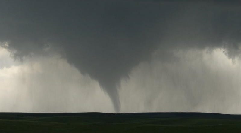
Figure 93. Streamers of condensation emerging from the surface in Krasnozavodsk, Russia, 2009-06-03, courtesy English Russia. The tornado went on to do EF3 damage. Click here to watch the associated video.
The more plausible explanation is that these filaments are evidence of electron streams shooting down from the cloud (or rarely, up from the ground, as in Figure 93). As such, the speed with which they can move, and the visible effect that they have, become easy to understand. The water vapor in positively charged air subjected to an extreme low pressure will condense instantaneously if the necessary electrons become available, so the only limiting factor is the speed at which an electron avalanche can move, which isn't much of a limitation. More problematic for fluid dynamics is the filamentary nature of the condensation, but this is an expected property for an electric current, and for two reasons. First, electron streams are subject to the magnetic pinch effect, which consolidates them into filaments (as they are in lightning). Second, condensed water molecules are much more conductive than nitrogen and oxygen molecules. So once condensation forms, the current will flow through that condensation to get to the next parcel, producing the characteristic "frayed cotton ball" effect, which is not reproducible with fluid dynamics alone.
.png)
There have been many reports of unusual colors in tornadoes.
First, we can take another look at Figure 88, and notice the peculiar orange color of the vortex. This is an unusual color for condensation, which is typically white (or gray if it's in the shade). Occasionally the clear slot in the cloud allows the tornado to become sunlit, and we get a better look at the actual color, which is not always white. If a tornado has a reddish tint, this is typically attributed (correctly) to the presence of ferric oxide in the red clay dust kicked up by the tornado. But this tornado over the water isn't kicking up any red clay dust. Since hydrogen, nitrogen, and oxygen have emission lines in the orange~red bands, the most plausible explanation is that positive ions are getting bombarded by electrons in this region.
.jpg)
Second, there have been a variety of reports of tornadoes glowing in the dark, like neon lights.105,157,158,159 Blue and orange are the colors that have been reported. Since a corona discharge in the presence of ionized nitrogen and oxygen produces such colors, the most likely explanation for this luminosity is that an electron stream is bombarding air molecules inside the tornado.
Figure 94. Two luminous tornadoes that did F4 damage in Toledo, OH, 1965-04-11, courtesy James R. Weyer.
Corona discharges in air normally require electrostatic potentials in excess of 100 kV/m.160 So how does a corona discharge occur in the 5 kV/m of potential below a supercell? The answer is that the threshold for a corona discharge is a function of the resistance of the air, and this varies with pressure. Lower-pressure air is a better conductor, and therefore will support a corona discharge in a weaker electric field. Hence the pressure drop within a tornado makes corona discharges possible with 5 kV/m of potential.28,110
Third, eyewitnesses inside powerful tornadoes (who were lucky enough to survive) have reported seeing "fingers" or "rings" of continuous arc discharges at the top of the tornado.161,162,163 From the outside, there have been reports of continuous ring lightning at the top of the tornado.31,105,122,164 Such reports are extremely rare, and because of this, thermodynamicists have dismissed the possibility of a causal role for electromagnetism in tornadogenesis.165 Such dismissals are based on the assumption that heat from lightning is the only way that electromagnetism could influence a thermal system. But in the EMHD model, ohmic heating from the current flowing from the cloud down to near the ground isn't terribly significant, so the dismissal doesn't apply to this model. Still, there have been enough credible reports that the phenomena are to be considered real, and any comprehensive explanation of tornadoes has to demonstrate plausible conditions, even if the model doesn't consider them to be prime movers.
If there is a flow of electrons down through the tornado, sufficient in some cases to generate a glow discharge, it's also theoretically possible that the discharge could be robust enough to graduate into a sustained small-scale arc discharge. This would be fundamentally different from lightning, which is a rapid release of potentials on a large scale. In contrast, arc discharges at the tornado/mesocyclone interface would be small but continuous, as negative charges drawn into the mesocyclone interact with a steady stream of positive charges in the tornado.
One of the curious things about tornadoes is that the inflow in laminar, and the base of the tornado is laminar, but the vortex sometimes converts to a turbulent flow before entering the mesocyclone. This is anomalous because if the source of energy is the low pressure in the mesocyclone, we would expect a laminar flow all of the way into the mesocyclone. Turbulent flows only occur when air is decelerating, while air responding to a low pressure always accelerates toward the source of the low pressure. This is clear evidence of an extreme low pressure at the ground, and that the low pressure relaxes in the direction of the flow.
Figure 95. Laminar-to-turbulent flow conversion in a tornado in southeast Colorado, credit Linda Lusk, courtesy NCAR.
Figure 96. Tornado with turbulent flow beginning just above the surface near Watkins, CO, courtesy NCAR.
Figure 97. Tornado shrouded by turbulence in Great Bend, KS, 1974-08-30, courtesy Bob Dundas.

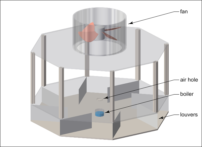
Such vortexes are actually fairly easy to create in the laboratory, using an apparatus similar to that depicted in Figure 98.166,167,168,169,170,171,172,173 The fan at the top motivates the airflow, analogous to a mesocyclone. At the base of the apparatus, there is a chamber with a hole in it. Inside the chamber, louvers impart angular momentum into the air, creating the vortex. A kerosene boiler adds vapor that condenses in the extreme low pressure going through the hole, and this makes the vortex visible. Glass panels (not shown) seal the central chamber, such that all of the air that is to satisfy the vacuum created by the fan has to pass through the small hole in the lower chamber.
Figure 98. Bottleneck vortex apparatus.
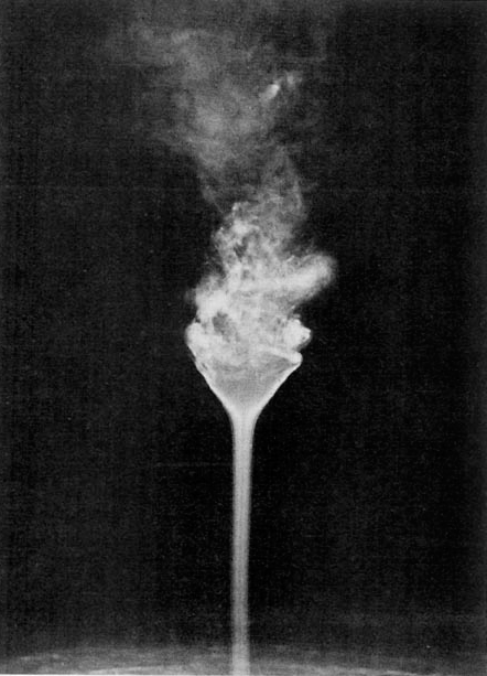
Figures 99 and 100 show the results, using different "swirl ratios" (i.e., the tangential velocity divided by the vertical velocity).
Figure 99. Laboratory demonstration of laminar and turbulent vortexes, courtesy C. R. Church.

Figure 100. Close-up of vortex breakdown, courtesy C. R. Church.

In the 1st panel of Figure 99, a small amount of angular momentum at the base creates a perfectly straight, laminar vortex. Note that this vortex should expand in the direction of the flow, as in Figure 85, but it does not, because of a simple difference. In Figure 85 we see that the mesocyclone is pulling air from all around, and then there is also the tornado pulling in air at the surface. As the tornado approaches the mesocyclone, the pressure outside the tornado drops, thereby reducing the centripetal force, which results in an expanding radius. But this apparatus is only pulling air from the bottom, so there is only one pressure gradient entirely within the vortex, and none of the effects of one gradient merging with another.
In the 2nd panel of Figure 99 (and also in Figure 100), with a larger swirl ratio, we see a phenomenon known as "vortex breakdown." With a high degree of angular momentum imparted into the vortex by the louvers in the base of the apparatus, the air that emerges is rotating faster than the surrounding air, and is therefore subject to friction that will slow it down. As it slows down, the laminar flow becomes prone to turbulence. The turbulence then allows the surrounding air, not subject to any centripetal force (because it is not rotating) to flow downward into the vortex, seeking the extreme low pressure at the base. A "downdraft" inside the vortex relieves the low pressure, and thereby reduces the centripetal force. This results in the rapid widening of the vortex just prior to its breakdown. Note that even in tightly controlled conditions, this configuration is extremely unstable. So it is no surprise that tornadoes like this (such as in Figure 95) are rare.
%202.jpg)
In the 3rd panel, with an even higher swirl ratio, the vortex breakdown occurs as soon as the air exits the hole (similar to Figure 96). And in the 4th panel, the turbulence is so robust that it shrouds the vortex (similar to Figure 97).
.jpg)
.png)
Hence the conversion from a laminar to a turbulent flow, in the direction of the flow, is very definitely possible, if there is an even lower pressure that occurs first. In the more general sense, an extreme low pressure, away from the source of the low pressure, is an apparent violation of the 2nd law of thermodynamics, unless there is a bottleneck upstream of the energy source. Then all of the rules change, and a vortex that expands (or even breaks down) in the direction of the flow goes from being impossible to being the only result that is possible. Meteorologists might not be familiar with the properties of bottleneck vortexes, because they only occur upstream of energy sources in closed systems, and the atmosphere is normally considered to be an open system. But bottleneck vortexes have been well-studied in a variety of engineering disciplines, where energy transport is typically accomplished in closed systems. For example, combustion within the cylinder of an automobile engine relies on the thorough mixture of fuel and air, which is accomplished with turbulent airflows within the cylinder. This turbulence is deliberately caused by drawing air through a very narrow gap (~0.16 mm) between the valve and the valve seat. So while the energy source during the intake stroke is the receding piston, the lowest pressure is not at the surface of the piston — it's just past the valve gap. This isn't a violation of the Second Law — it's just the expected properties of a bottleneck in a closed system.
The sections entitled "Lab Suction Vortexes" and "Atmospheric Vortexes" demonstrated that tornadoes defy the principles of typical (open-air) suction vortexes. Now we see that tornadoes have precisely the properties of bottleneck vortexes. This can only mean that tornadoes are behaving as closed systems, in which there is a bottleneck in the airflow, creating a build-up of energy that is released at the base when the air finally gets past the friction at the ground. Making sense of this, in terms of open-system thermodynamics, just isn't going to work, since none of the behaviors of open flows are present, and all of the behaviors that are present are only treated by closed-system thermodynamics. So we have no choice but to acknowledge that there has to be some sort of bottleneck in the flow. But what could cause a "bottleneck" in the atmosphere?
There is really only one possibility here, because there is only one other force present: electromagnetism. Since air is not responsive to the magnetic force, only the electric force could be powerful enough to accomplish such a feat in the atmosphere. If the tornadic inflow is electrically charged, and is therefore experiencing an electrostatic attraction to an induced charge in the Earth, it will be subjected to much more skin friction, and it will not detach from the boundary when expected. This means much more frictional heating, and much more Rankine acceleration. When the charge is neutralized by an electric current inside the tornado, the air is released from its attraction to the ground. The net effect will be the same as if there was a big piece of plywood with a hole in it.
More recent attempts at generating tornadic vortexes in the laboratory use a different apparatus.174,175,176,177 Instead of the lower chamber with a hole in it, the plenum of the fan feeds down around the outside of the apparatus, as shown in Figure 101.
Figure 101. "Tornado simulator," redrawn to scale from Gallus et al. (2004).

Relevant results were achieved with the flow rate at 59 m3/s, and with the outer casing brought to within 0.1 m of the base of the apparatus. This research confirms that a tornadic vortex is not possible unless there is a force capable of restricting the inflow to the surface. That force could be a piece of plywood, a metal shroud, or an electric charge. Outside of the laboratory, it can only be an electric charge.
A debris cloud is a funnel of dust and dirt that sometimes gets stirred up at the base of the tornado, and is then accelerated upward and outward from the tornado, outside of the vortex. It moves rapidly at first, and then the speed decreases until the debris achieves some sort of equilibrium, hovering 100 m or so above the ground, and rotating slowly around the tornado. The total mass of the debris cloud can reach tens of thousands of tons.178 (See Figures 68, 102, and 103 for examples.)
.jpg)
The persistence of debris clouds outside the vortexes clearly demonstrates that tornadoes only pull in air at the ground, in spite of the skin friction, thereby defying the principles of fluid dynamics. This is yet another proof that something is binding the inflow to the ground. This can only be evidence of an electrostatic attraction between the inflow and the surface of the Earth.
Figure 102. Tornado that did F5 damage in Elie, Manitoba, 2007-06-22, courtesy Justin Hobson.
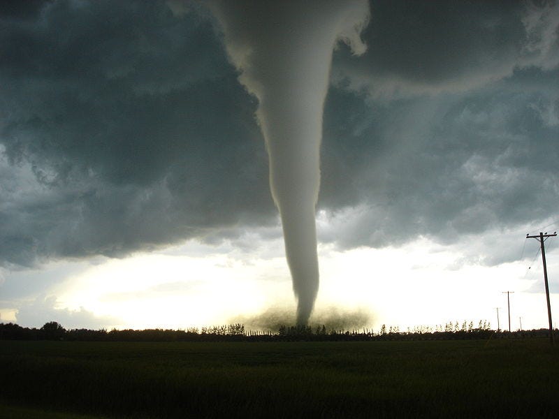
Figure 103. Tornado that did F4 damage in Manchester, SD, 2003-06-24, courtesy Matt Grzych.
The interesting thing about the debris cloud is that it proves that in addition to the robust inflow to the tornado, there is also a small but powerful outflow with its source near the mouth of the vortex. So despite the extreme low pressure, some of the air shoots upward outside the vortex.
The common explanation for the distinctly different airflow in the debris cloud, as compared to the flow into the tornado, is that particulate matter stirred up by the tornado is being ejected. Due to its mass, it experiences more centrifugal force than the air, but due to its low terminal velocity, it drags air with it. This has clear air moving inward, and dusty air moving outward, and the high pressure between them is then the force that sends the dusty air shooting upward.
But if that's true, it's backwards, and self-defeating. By definition, the centrifugal force of the particulate matter is parallel to the ground plane. If its inertia is the dominant force, the inertia of the clear air is the subordinate. So the clear air should lose the battle and get accelerated upward, not the dusty air. But if that was the case, the dusty air would establish a boundary layer between the inflow and the ground, which would prevent the fast-moving inflow from stirring up more dust. And the dusty air would be subject to skin friction that would slow it down, which means it wouldn't keep kicking up dust. So if a suction vortex did stir up any dust, the dust would shoot out parallel to the ground, which would extinguish the effect. A steady outflow, shooting upward at the mouth of the vortex, should not be possible. Perhaps this is why a debris cloud has never been reproduced with a suction vortex in the laboratory.
To get this sorted out, we should remember that an EF1 tornado expends millions of watts of power at the ground, fighting skin friction, and an F5 tornado expends billions of watts. All of that power is, of course, thermalized. We should also remember that the inflow is hugging the ground, from at least 1 km away. This means that the temperature of the inflow rises as it approaches the vortex.
If we then inject the present hypothesis — that the air is bound to the ground by the electric force, and can only ascend once released from that force — a far more plausible explanation emerges for debris clouds. The air is positively charged, and the Earth has an induced negative charge. That means that the dust is negatively charged, and might easily be lofted by the electric force into the inflowing air. Once this happens, the effective charge of the air is neutralized. If this occurs outside of the vortex wall, the air is already free to ascend. It is still within the scope of the low pressure at the mouth of the vortex, so that should still be the dominant force. Yet recalling that the air has been heated by friction, we now have a context in which the air might ascend before entering the vortex. If so much heat is generated that the air's buoyancy is more powerful than the net inward force (low pressure minus the centrifugal force), the air will shoot upward instead of being drawn into the tornado. Once neutrally charged and out of the inflow, the air will find an equilibrium based on its buoyancy minus the weight of the debris.
Figure 104. Debris cloud.

If the debris cloud is lofted 100 m, but it also contains dust, we might come up with a guess of what temperature difference it would take by just calculating the difference necessary to loft the air 500 m. The pressure difference in the first 500 m of the atmosphere is 5%. To increase the buoyancy of the air by 5%, we have to raise its absolute temperature by that amount (per Charles's Law).
resultant temperature = 20 °C × 5% = 293 K × 1.05 = 308 K = 35 °C
So in the relevant temperature range, we need a 15 °C difference. If the tornadic inflow rate is 16,000 m3/s, perhaps the debris cloud flow rate is 1,000 m3/s. So we need to raise the temperature of 1,000 m3/s by 15 °C. Raising the temperature of 1 m3 of air by 1 °C in 1 second requires approximately 1,340 watts.
unit watts = 1,340 W·°C·m3·s × 15 °C = 20,100 W·m3·s
total watts = 20,100 W·m3·s × 1,000 m3/s = 20,100,000 W
Since the continuous power output of tornadoes due to skin friction is considered to be in the range of 5 million watts for an EF1, up to 5 billion watts for an F5, 20 million watts is within range for an EF2+ tornado.
Confirmation that temperature, not centrifugal force, is the energy source in the debris cloud could be achieved with infrared videography from a distance, though catching a tornado in this rare condition with specialized instrumentation (even from a distance) would require a substantial storm-chasing effort (i.e., a lot of money).
Sometimes tornadoes pull some or all of the debris cloud into a sheath that has a consistent diameter, no matter how high it extends. (See Figures 105~108. See the video associated with Figure 90 to watch a dust sheath forming.)
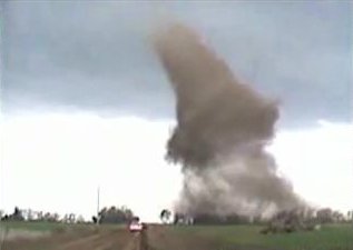
Figure 105. Condensation funnel, debris cloud, and dust sheath, courtesy Arkansas Tech.

Figure 106. Condensation funnel and dust sheath, courtesy Arkansas Tech.
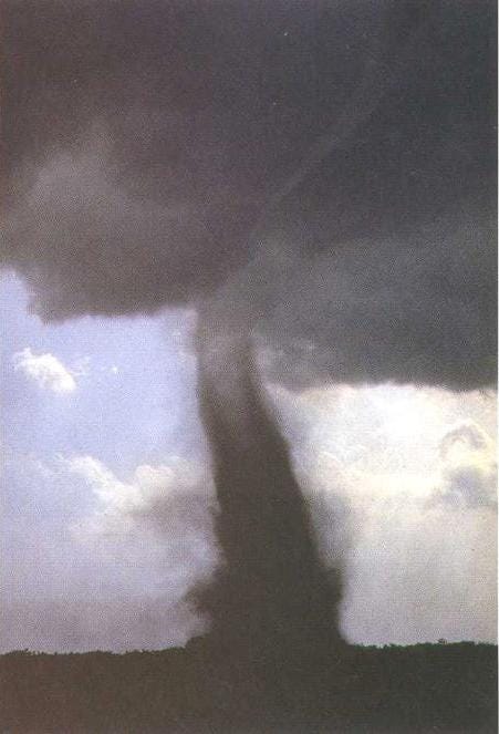
Figure 107. Condensation funnel and dust sheath in southeast Colorado, credit Linda Lusk, courtesy NCAR.
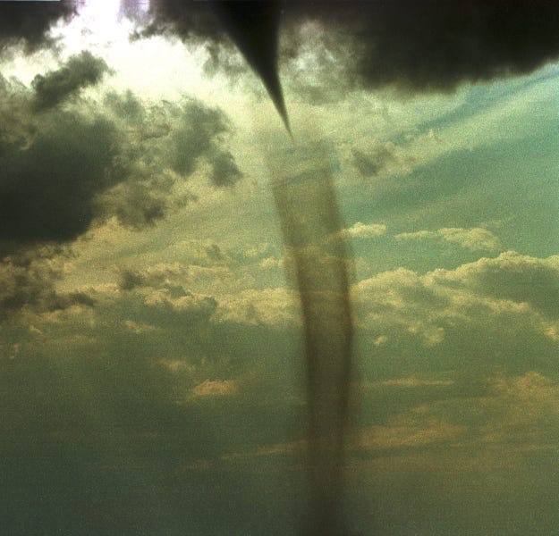
Figure 108. Condensation funnel and dust sheath in Lincoln County, NE, 2004-05-22, courtesy NWS.
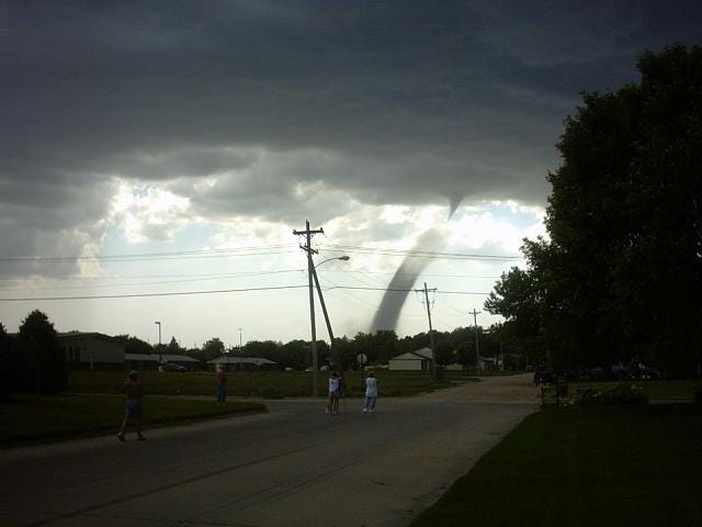
It has been proposed that dust sheaths are the result of particles of different masses getting centrifuged out of the vortex at different rates.151 But tornadoes do not pull in any air above the ground level, so there is no force to selectively impede the centrifugal force. Therefore, large particles should be ejected rapidly, and small particles slowly, but there shouldn't be any concentration of particles, large or small, at any specific radius.
Electromagnetism can very definitely supply such a selective centripetal force, on the basis of the electric charge. But to understand how, we first have to identify the charges. In the section entitled "Baseless Tornadoes" we saw that a condensation funnel defines the extents of full neutralization. If the funnel does not reach the ground, the air at the base of the tornado still has a net positive charge. If we take a second look at Figures 105~108, we see that all of the tornadoes have condensation funnels that do not extend below the top of the dust sheaths. This means that the air inside the sheaths is still positively charged. In the section entitled "Debris Clouds" we saw that airborne dust has the charge of the Earth, which is negative. So we know that the dust sheath is negatively charged, and the air inside the sheath is positively charged. Hence there will be an electric field between them.
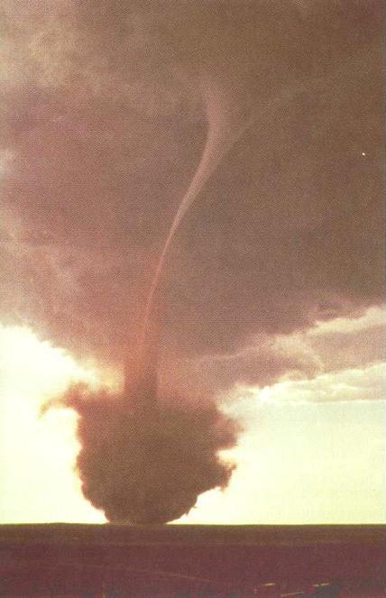
.jpg)
This field varies with the inverse of the square of the distance. As such, it exerts a centripetal force on the charged particulate matter similar to the centripetal force exerted by the low pressure on the gas molecules (which varies with the inverse of the square of the distance also). So the dust will fall into a circular path at the radius at which the centripetal and centrifugal forces are equal, and this will always be at some distance from the center, as the centrifugal force is always greater nearer the center.
The difference is that the centripetal force generated by the electric field will also vary with the charge/mass ratio of the particle. Since we can't expect all of the dust to have precisely the same charge density, we still don't have an explanation for the distinct sheath.
Now if we recall that tornadoes do not pull in any air above the surface, we get our explanation. Because a tornado is a sealed pipe, with a centrifugal force emerging directly at the ground level that locks in the low pressure, the vortex simply passes through the air above the ground, without pulling any of it inward, and therefore without inducing any rotation in it. This produces a steep velocity gradient outside the vortex wall. When dust is ejected by its centrifugal force into this velocity drop-off, it rapidly loses its centrifugal force. Then it has no reason to move further from the center of rotation, resulting in a build-up of dust at the boundary between the vortex and the stationary air outside of it.
In this context, it makes sense that this phenomenon is most common in non-mesocyclonic tornadoes, where the tornado feeds into an updraft that isn't rotating. The air under a mesocyclone is rotating, so the velocity gradient outside the tornado isn't as steep. This means no sudden drop in centrifugal force, and therefore, no accumulation of particles just outside the vortex wall.
It also makes sense that the condensation funnel is pointed, when in other cases (such as Figures 87~89) we see truncated funnels. As the negatively charged dust is centrifuged outward, it pulls the most positively charged air molecules outward as well, leaving weaker charges in the center of the vortex. Where the net charge is the weakest, condensation forms first. So, if the charge neutralization at the ground level is not complete, we will not see condensation, even in the extreme low pressure there. Rather, condensation will form higher up. Typically the condensation funnel is truncated, but if there is a dust sheath, there will be a charge stratification inside the vortex, and the weakly charged water vapor in the center will condense first.
.jpg)
.png)
Another sort of core-and-sheath configuration is sometimes visible in waterspouts, where the core does not taper to a point, and the sheath doesn't fall apart when encountering the core — rather, the core maintains a consistent radius, and extends below the bottom of the sheath. (See Figures 75 and 89.) The difference is that the "sheath" isn't dust particles getting centrifuged out of the vortex — it's condensation in the vortex wall. As such, it isn't charged, so it doesn't need a charged core to keep it organized, and the viscosity of the air is sufficient to keep it in place.
But this doesn't mean that EM principles are not necessary to explain this phenomenon. The core-and-sheath configuration is not possible in fluid dynamics, since the pressure should be the same everywhere inside the vortex wall, because the pressure equalizes at the speed of sound, and the velocities are sub-sonic. So there is no way for the pressure to be low enough for condensation in the vortex wall, then for that pressure deficit to relax, and then increase back to the dew point at the center of the vortex. Hence this has to be electromagnetic.
If the condensation funnel defines the extents of the neutralization, and if condensation is a better conductor than gaseous nitrogen, oxygen, or water vapor, the internal funnel reveals the electrical conduit through which the current flows. This could project all of the way to near the lower boundary before its excess negative charge would be scavenged by the positively charged inflow.
Figure 109. Charge streams in a waterspout (with the horizontal dimension exaggerated).

This is interesting because there is evidence of downdrafts inside tornadoes moving at 30 m/s or more,149,179 as represented schematically in Figure 110.
Figure 110. The Sullivan model, in which air flow descends from above and flows outward to meet a separate air flow that is converging radially.
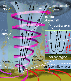
Clearly, the energy source in such a flow field has to be at the base of the vortex, to motivate the reverse flow inside the vortex, and at the same time pull air inward along the ground. And the collision between the internal and external flows is the only way to get the sudden change in direction in the "corner region." The critical conversion can only be charge neutralization, releasing the thermal potential of the inflow. But the evidence of a downdraft inside the vortex suggests that it isn't just an electric current flowing from the main negative charge region inside the cloud, down to the positively charged inflow. Ohmic heating would rather drive an updraft. So the downdraft is more likely evidence of negative ions transporting the charge, not free electrons in a Townsend avalanche. These are harder to accelerate than free electrons, and the weak electric field shouldn't be capable of overpowering the buoyancy of air from higher altitudes. Downdrafts are only possible when evaporative cooling increases the density of the air. Yet this is precisely what we would expect if electrons are getting stripped to recombine with the positively charged inflow. The loss of electrons breaks the covalent bonds holding water particles together, forcing evaporation. The result is a heat exchange, with a corresponding downdraft. So near the base of the vortex, the core charge becomes increasingly positive, accelerating the air downward. When it hits the boundary, it splays outward, and collides with the far warmer inflow, which has been released from the boundary by neutralization, and is now rising.
In addition to the current flowing down through the tornado, there is also evidence of a current flowing through the ground.112 The F4 tornado in Worcester, MA, on 1953-06-09, was detected from 150 km away on the basis of telluric currents.180 This current appears to coincide with the tornado, so it would not be useful as a predictive mechanism, but might nevertheless be useful to confirm the presence of a tornado, and possibly even estimate the strength of it, which would be very valuable information to have in real time.
The direction of the current was not identified, but the EMHD model offers a suggestion. If there is an induced negative charge in the Earth, and if dust is being picked up by the tornado (by the low pressure and by the electrostatic attraction to the positively charged air flowing into the vortex), there will be a net loss of negative charge in the Earth due to the tornado. This means that more electrons will flow in from the environs, attracted to the positively charged air below the storm.
Figure 111. Hypothesized telluric currents under a tornadic thunderstorm.
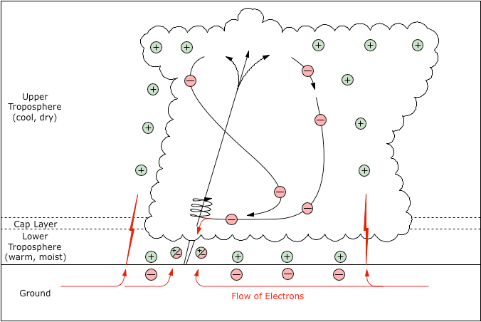
This agrees with electric field measurements near and inside the F4 tornado that struck Allison, TX, on 1995-06-08.30 The strength of the electric field was an unimpressive 3 kV/m, but the researchers noted an interesting correlation between the electric fields and the incidence of lightning around the edge of the storm.
The electric field at the two instruments in the vortex relaxed to zero quickly after the lightning flashes, whereas the electric field at nearby instruments outside the vortex did not relax quickly after the same lightning flashes.
Since it was an F4 tornado, it's safe to assume that it was kicking up a lot of dust, meaning that there would have been a telluric current, with electrons flowing toward the tornado. Assuming that the lightning strikes were "positive" (in which the strikes were between positive charges in the cloud and negative charges in the ground), the lightning would have cut off the supply of electrons toward the tornado. The absence of electrons would be the most apparent under the tornado, where negatively charged dust was still getting kicked up, depleting the supply. Hence the induced negative charge in the Earth would have disappeared briefly as a consequence of the lightning strikes. The electric field outside of the tornado would not have been altered, as the rapid shift in the current would not have left the Earth without any charge at all.
Tornadoes are a type of suction vortex, and the general public has come to think of them as giant vacuum cleaner hoses that can pick up large objects in precisely the same manner as a household vacuum cleaner picks up small objects.164,181,182 Figure 112 is taken from a video that is frequently cited as an example of the "suction power" of a tornado.
Figure 112. Cars picked up by tornado in Leighton, AL, 2008-05-08, courtesy S&M Equipment Company. Click here to watch the associated video.

But it's naïve to think that a typical suction vortex has lines of motion capable of producing such levitation. For a suction vortex to bind effectively to a boundary, the swirl ratio has to be > 1, meaning more rotation than elevation.
Figure 113. Suction vortex with roughly a 2:1 swirl ratio, courtesy Reel EFX, Inc. (To mimic a tornado with a narrow base, dust is being released just at the very center of the vortex.)
Both the tangential and the vertical velocities will accelerate objects in the flow field, at a rate that varies directly with the skin friction and inversely with the mass. But the tangential velocity doesn't have to overcome gravity, and if it is greater than the vertical velocity anyway, the tangential acceleration will be far greater than the levitation. Yet we can clearly see in the video associated with Figure 112 that the cars were picked straight up.
.png)
This is clear proof that the lines of motion in a tornadic vortex are fundamentally different from those in a standard suction vortex. Inside the vortex, the air shoots straight up, forgetting its angular momentum, just like the air in the debris cloud (if present), and for the same reason. The strong vertical velocity can only be evidence of a powerful energy conversion near the ground, which can only be thermal buoyancy released from an electrostatic attraction to the ground.
This upward acceleration helps account for the fact that 75 m/s winds in a tornado do the same degree of damage as 100 m/s straight-line winds. The standard explanation for the difference is that a suction vortex can straddle a building, creating a twisting force that combines with the low pressure above the roof to create unusual stresses.173 (See Figure 114.) This would be reasonable if tornadoes actually straddled objects in the flow field like a suction vortex, which they do not. In reality, the "unusual stresses" are more probably the result of an updraft that begins at the ground level. The downward force of gravity adds strength to the walls of a building. If that force is relieved when the building is subjected to a powerful updraft, the walls will fail with less lateral force. This means that buildings should be engineered to withstand 75 m/s vertical winds instead of 100 m/s straight-line winds.
%209.png)
In a more general sense, it's instructive to note that tornadoes are rated by the degree of damage, not the speed of the winds. In the early days of tornado research, when usable tornado videos were rare, the degree of damage, measured after the fact, was the only information that meteorologists had. But even when high-quality videos are available, meteorologists generally won't bother doing the photogrammetry to determine the speed of the winds, because this isn't directly related to the degree of damage. Yet within the EMHD model, studying the discrepancy would be useful, as it is a measure of the degree of electrification.
In addition to the effects of an updraft in or near the vortex, there is another type of "levitation" that sometimes occurs at some distance from the vortex. Scientists have not applied any critical scrutiny to these reports, and the common "explanation" is flatly absurd. A tornado was nearby; tornadoes are suction vortexes; things were picked up; any questions? Yet outside of the vortex, the lines of motion are parallel to the ground. So the vertical motion in or near the vortex would be irrelevant, even if the conventional framework could explain it. A critical treatment of the topic requires that we explain how objects are picked up just with horizontal air motion.
For example, during the tornado that hit La Plata, MD, on April 28, 2002, a bus with 30 people aboard was lifted off the ground, kept suspended in air for several seconds, and then set back down on the wheels. While some of the passengers had been injured by flying debris coming through the broken-out windows during the high wind speeds before the levitation, no one was injured by the impact of the bus coming back down after being picked up.
Here's a similar report, again from Maryland, this time from Steve Tracton, Ph.D. (meteorology):
In 1995, I was in my car one night, patiently waiting the opportunity to turn from a driveway onto a street in Temple Hills, MD, when seemingly out of nowhere the wind increased to what I perceived as hurricane strength. Needless to say, I was totally surprised and scared beyond belief when my car rose at least two feet off the ground. Fortunately, the wind decreased as rapidly as it had increased, and my car settled back down on the driveway.
The same kind of thing happened on 2013-05-31 to Terri Black, 51, a teacher's assistant in Moore, OK, as reported by the Associated Press.
My car was actually lifted off the road and then set back down. The trees were leaning literally to the ground. The rain was coming down horizontally in front of my car. Big blue trash cans were being tossed around like a piece of paper in the wind.
Here is another eyewitness report of a car being picked up by a tornado, and a photo of the results.
The man in the house near us was very lucky. He was in the yard and was hanging on for dear life and watched his car raise about 5 feet in the air and float for a few feet toward his house. The car then was gently lowered on his fence and it tilted on its side and was gently lowered to the ground. His house was not touched and he was next to the car and was not harmed. He was hanging on that corner post that you see with the brace on it.
Figure 115. Damage from tornado in Zaria Svobodi, Russia, 2009-06-13, courtesy Kyle and Svet Keeton.
When further questioned on how the car came to rest in this position, the eyewitness elaborated:183
The car actually floated after the main body of the tornado passed over head and was out of sight. The winds were still strong but I was watching the car as was the man who owned the car. The wind damage was done and the car just gently lowered onto the fence. It did not crash to the ground. The fence held the car side up and the car tipped then gently lowered on its side.
Yes, slight damage but the car was uprighted after the fence removed and driven away. No dents except slight impressions from rocks and such as it laid on its side...
There is no question that a car can become airborne in crosswinds above 60 m/s, which is in the EF2 range.184 (See this video for an example.) Contrary to popular belief, it is not the Bernoulli Effect that can lift a car with low pressure above it. Rather, when air broadsides a car, some of it gets forced underneath, and the high pressure below the car is the force that lifts it up. But once off the ground, the car is then rapidly accelerated in the direction of the wind, and hits the ground (for the first time at least) 5 m or more away. Furthermore, the car will be picked up at or before the peak wind speed has been achieved. Yet these vehicles were picked up after the winds had begun to subside, and once picked up, they hovered for a while before "settling back down." Lateral winds are not capable of such effects.
Here's another example, again from Russia. It's clear that the truck had been exposed to high winds, since the damage to the truck body would have been caused by flying debris. But it's also clear that the truck was not rolled by the high winds. So it was picked up and kept upright, and then set on the car. In winds strong enough to pick up the truck, why didn't the truck get rolled? And how could the lateral acceleration be so slight as to allow the truck to come to rest teetering on the car like this?
Figure 116. Damage from F3 tornado in Krasnozavodsk, Russia, 2009-06-03, courtesy English Russia.
There are also confirmed reports of people being picked up by tornadoes, and sometimes carried for some distance, and then set back down gently enough that they were relatively unharmed. The longest confirmed distance that a tornado carried a person who survived was 400 m.185 The person suffered no injuries when hitting the ground. A critical analysis reveals that a fluid dynamic explanation is just not possible. A human body simply isn't an aerodynamic shape, and even at the maximum near-ground wind speeds in a tornado (~100 m/s), it will not generate lift in excess of the force of gravity. So like cars, the only way that a human body can be lifted by wind is if there is a small gap between the object and the ground into which high-pressure air can be forced. But once the object is lifted, the high pressure is relieved, and the object falls back down. Near the ground, it is slightly cushioned by air flowing under it, but as the drag force accelerates the object, asymptotically approaching the speed of the air, the cushioning effect diminishes, and the object hits the ground. On bouncing, the process repeats, as the gap is filled with high-pressure air that lifts the object again. This is a well-known process called saltation, resulting in the object "skipping" across the ground. There are no statistics for the skipping distance of a saltating human body, but since objects such as cars, with shapes more prone to it than human bodies, typically travel no more than 5 m before hitting the ground, we can use that as an upper limit. In a distance of 400 m, hitting the ground every 5 m would mean 80 bounces. Yet in the case cited above, the person was airborne for the entire 400 m, which is way out of range for saltation.
And then there have been cases where entire houses have been picked up and carried, and then set back down, damaged but still relatively intact. The anomalous aspect of this is not that an object as big as a house could be picked up. Houses are mainly empty space, with plenty of surface area upon which the winds can exert force. But houses simply are not built in such a way that they can be picked up, except from underneath, without falling apart. Without being able to get underneath the house to pick it up, the only other way to generate the necessary uplift without destroying the house is with a force that can act upon the entire mass at once. There are only two such forces in nature operative at this scale — gravity and electromagnetism. It's not gravity, because the houses were picked up. That leaves electromagnetism.
In the EMHD model, the tornadic inflow is positively charged, and the surface of the Earth has an induced negative charge. This means that particulate matter from the surface that is getting blown in the wind will be negatively charged. Objects exposed to the tornadic inflow (such as people, cars, etc.) will be sandblasted with this particulate matter, and will therefore develop a net negative charge. The objects will then be attracted by the electric force to the positively charged air around them. Since there is more air above them than below them, the net force will be upward. And if the strongest positive charge in the storm is in the RFD, objects will be subjected to the most powerful uplifting force after the tornado passes.
Figure 117 shows a house that was picked up and moved by winds that were rated EF2 (because of the removal of the roof), but the car in the garage was left untouched. This is anomalous because EF2 winds are capable of blowing cars off of roads, or even picking them up.184
Figure 117. House relocated by the EF5 tornado in Greensburg, KS, 2007-05-04, courtesy Tim Marshall.
It's possible that the house lost its roof in the EF2 winds, but it was not the lateral winds that picked up the house and moved it. Rather, the house was subjected to triboelectric charging as the tornado passed overhead, and then after the winds subsided, the house was picked up and set back down 20 meters away by the electric force. The car inside the garage was shielded from triboelectric charging during the strongest winds, so it did not experience the same uplifting force later.
The exact EM configuration responsible for the levitation has not been identified, since the electric field necessary for levitation shouldn't be present. Let's assume that the mass of the car is 1,000 kg. The weight is then equal to m×g, where g is 9.8 m/s2, so the force necessary to lift the car is 9800 N. The force on a charge is given by F=q×E, thus q=F/E. Assuming a high-end electric field of 100 kV/m, the charge must be 9800/100,000 = 0.098 Coulombs. The problem is that if we pack all of that charge into something the size of a car, it produces too strong of a field. For a quick estimate, we can find the field generated by that much charge placed on a conducting sphere with a radius of 1 m. The electric field on the outside of the sphere is given by:
F=q / (4πε0r2)where:F=force (newtons)q=charge (coulombs)ε0=Permittivity of Free Spacer=distance between centers (m)
If q is set equal to 0.098 Coulombs, the electric field at the surface of the sphere will be 0.098 / (4 * 3.14 * 8.85 * 10-12 * 12), or 880.78 MV/m, which is 2 orders of magnitude above the breakdown voltage of the air. If the electric force is doing the work, the only possibility is that the field is actually that high, but that the charge on the car doesn't dissipate because the work function of the metal isn't exceeded. It takes 9 GV/m to liberate electrons from a cold metal electrode. So the ambient field might be as little as 100 kV/m, but the field concentrated the car might be 881 MV/m, and charge loss to corona and/or arc discharges is prevented by the field still being an order of magnitude less than the work function.
We should now take an even closer look at the most anomalous cases — the ones in which the objects actually hovered. The reports are consistent in asserting that the fastest winds had already passed, and the eyewitnesses guessed the wind speeds at something like 30 m/s when the objects started "floating." Such winds are clearly insufficient to levitate the objects, and this section presents the more plausible explanation, that the electric force was at work. Yet even in 30 m/s winds, we still wouldn't expect objects to hover — the drag force should have accelerated the objects in the direction of the wind. For example, when Dr. Tracton's car was picked up at least two feet off the driveway, there shouldn't have been a way for it to "settle back down" onto the same driveway. (Watch the videos of cars being picked up by high wind speeds.) The car should have hit (first) at least 5 m off the driveway, and Dr. Tracton probably wouldn't have lived to tell the story.
If we consider the conditions in which this will happen, we find the answer. The objects were subjected to triboelectric charging as the tornado passed by. Then they were levitated. This means that they were then between the RFD and the tornado. There the winds will be traveling from the RFD toward the tornado, and we expect any object levitated in that air to be accelerated in the direction of the winds, toward the tornado. This proves that there has to be a force pushing the objects away from the tornado and/or pulling them toward the RFD. And that force can only be the electric force.
So far, we have considered a positive space charge above the conducting Earth, generating an electric field with lines of force oriented vertically. But if the RFD is the primary source of positive charge, the lines of electric force would not have been straight up. If we look at Figure 81, and assume that the entire RFD is positively charged, and then consider the force exerted on a negatively charged object halfway between the RFD and the tornado, we see that the net force will be angled upward, toward the main body of charge in the RFD. (See Figure 118. Note that while electric lines of force intersect a plane conductor perpendicular to it, the Earth is only an excellent conductor below the water table, and the soil above the water table could be a good or fair conductor. So the lines of force will not be perpendicular to the surface, but rather, to the water table, which could be several meters below the surface.) Furthermore, the nearby tornado has a higher conductivity than the surrounding air, which also attracts the lines of electric force.
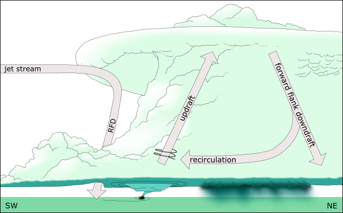
So while the wind will be blowing toward the tornado, the electric force will be upward and back toward the RFD, the net result of which could be no net lateral acceleration. It would be a rare case indeed that the forces happened to be perfectly matched. And so it is in fact. Nevertheless, this is the only way that hovering in 30 m/s winds is possible.
Figure 118. Stack of positive charges above a solid conductor. Electrostatics applet by Paul Falstad.
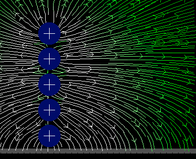
Eyewitnesses to the destruction of houses by tornadoes frequently claim that the houses "explode" upward and outward. The following is a quote from UCAR on the topic.
Scientists once thought that you should open your windows during a tornado. The thinking behind this was that the extreme low pressure in a tornado would cause the air in your house to explode. Opening your windows would let the air expand without damaging your house. As it turns out, houses aren't as sealed as they thought so the air would have no problem getting out.
That much is true. But the quote goes on to say:
It turns out that the strong winds associated with a tornado can lift the roof off a house. Without the support of the roof, the walls are blown down and they fall outward. The roof may be dropped back on the rubble or some place nearby. This gives the impression that the house exploded.
Are we really to believe that the walls will simply "fall outward" because there is nothing tying them together at the top? All other factors being the same, a vertical wall experiences no horizontal force. 30 m/s winds will easily blow down an unbraced wall. And the wall will fall in the direction of the winds. In winds sufficient to tear the roof off a house (50~60 m/s), it is not physically possible for an unbraced wall to fall down against the wind.
More problematic is the fact that the roofs are, indeed, lifted straight up, and then can sometimes fall straight back down, or land nearby. The standard explanation for the uplift is a set of forces known collectively as the Bernoulli Principle,186,187 but which is ignorant of simple fluid dynamic principles, and of the context in which they are instantiated. First, even if the gable roof did not have eaves, the sharp edge at the peak of the roof will produce an eddy on the leeward side that will eliminate the possibility of aerodynamic uplift. (See Figure 119.)
Figure 119. Airflow over a gable roof without eaves, courtesy Hui Hu, Zifeng Yang, Partha Sarkar and Fred Haan.
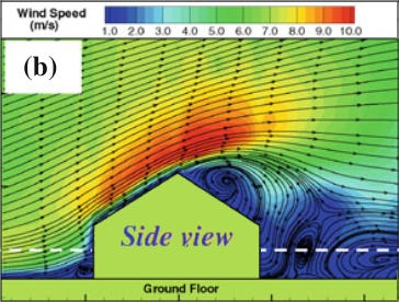
In reality, gable roofs always have eaves, and if these are taken into account, the shape of the roof doesn't even matter. In an EF1 tornado, the winds only do shingle damage near the peak. (See Figure 120.) In an EF2+ tornado capable of removing the roof, the upper surface is actually in an eddy (not shown) with pressure near ambient. This means that the force that tears off the roof can only be high pressure under the eave. The roof is then pealed back, like the lid of a sardine can, and it is to be found nearby, upside-down, and with most of the shingles still attached (except near the peak).
Figure 120. Airflow over a gable roof with eaves, given 3 different base rates.

This leaves us without an explanation for roofs getting lifted straight up and falling straight back down. If it's not aerodynamics, the only other possibility is that it's the electric force. If so, there are two possible signs of charge that could be at work, and there aren't enough data to distinguish between the two. It's also possible that either sign of charge could dominate, for different reasons, and that some of the distinctive behaviors are evidence of which sign was present.
First, it's possible that the house becomes negatively charged, by getting sandblasted with negatively charged particulate matter, or by ingesting such particles through broken-out windows. Once the house develops a negative charge, it will be attracted to the positive charge aloft. This is the more likely explanation if the entire house gets levitated (as discussed in the previous section). It might also explain cases in which just the roof was picked up, which then hovered until flipping over, releasing a cloud of dust. The suggestion here is that the dust was negatively charged, and as such, it exerted an upward force on the roof, and kept the roof suspended in the air until the roof flipped over.
The other possibility is that the house becomes positively charged. If there is little or no dust in the tornadic inflow, the space charge of the air itself will dominate. As the positively charged air flows through, around, and over the house, it pulls electrons out of the house, leaving it positively charged. In this case, the electric force that would cause the "explosion" would simply be the electrostatic repulsion of each piece of the house from each other piece. If the structure fails, the pieces will be accelerated upward and outward (simply away from each other), and then they will fall to the ground.
One of the implications of a positively charged house is that it will be structurally weaker. Ionization loosens the covalent bonds that give solids their strength. So the factors acting on the house might include all of the following:
lateral and/or vertical aerodynamic force,
electrostatic repulsion, and
weakened structural beams, posts, and fasteners.
This might also help explain why building materials (such as lumber) seem to "disintegrate" under the force of a tornado, to a degree that cannot be explained simply by the force of the winds. Some damage assessments have explicitly mentioned the surprisingly small size to which everything was reduced. This would make more sense if all of it had a strong positive charge, and therefore did not have its normal strength.
Another observation that might be related comes from the "Thunderstorm Project" (1946-1949), in which pilots flew WWII fighters fitted with weather instruments into thunderstorms. One pilot reported that the interior of the storm suddenly changed from jet black to bright yellow, accompanied by constant electrical activity. At the same time, personnel on the ground observed a tornado descending from the wall cloud that had formed. When the pilot returned to base and the plane was inspected, it was found that rivet heads had been peeled off of the wings. Interestingly, the pilot did not report experiencing G forces sufficient to cause such damage.188,189
The bright yellow color can only be reasonably explained as a glow discharge in highly ionized air. (See Figure 56 for the emission spectra of hydrogen, nitrogen, and oxygen.) Other reports of cavernous voids inside thunderstorms suggest that this was not a fluke, while the colors are more typically blue~green, which would be emissions from ionized nitrogen and/or water molecules. In the EMHD model, positive double-layers build up around recirculating negative charge streams. Being positively charged, the water content will be entirely gaseous, explaining the emptiness in the middle of a storm. A positive double-layer on the inside of the recirculation could be especially charged, and could support a glow discharge between it and the negative charge stream around it. And flying through air with a strong positive charge could have resulted in rivet heads being weakened.
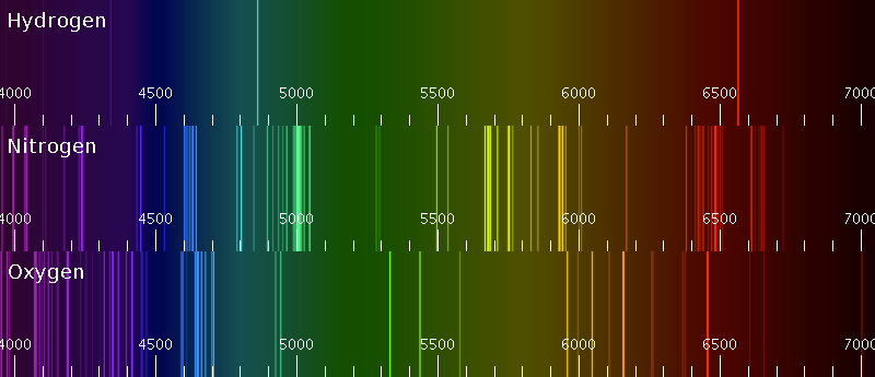
There have also been numerous cases of unusual combinations of strength and weakness in the collisions of objects in tornadoes. Some of these are easily explained away. Figure 121 is frequently cited in cult literature as an example of the bizarre things that a tornado can do. It is easy to understand how a projectile moving at 100 m/s could penetrate wood. The hard part is understanding why the vinyl didn't shatter.
Figure 121. A phonograph record blown into a telephone pole, courtesy NOAA.
It is somewhat more plausible to assume that the record did not get driven into the windward side of the pole, but rather, into the leeward side. With 100 m/s winds against the pole, it would have been leaning, and this means that cracks in the wood (clearly visible in the photograph) would have opened up on the leeward side. Airborne debris could then fall in behind the pole, trapped in the eddy downwind of it, and then be drawn toward the pole. A piece of debris could then happen to get wedged gently into one of the cracks in the wood. After the winds subsided, the pole would have straightened up again, closing the cracks, and then gripping the debris tightly.
Other cases are harder to explain away, such as the board that was rammed through another board in Figure 122, and pieces of straw that were driven into telephone poles.
Figure 122. Damage from the Tri-State Tornado, 1925-03-18, courtesy NOAA.
Some of these cases are explicable just with Newtonian forces, but all of them become far easier to understand if the objects in question had been ionized.
To summarize this and the previous section, we can expect shorter objects (such as people and cars) in the tornadic inflow to become negatively charged as they get sandblasted with saltating particulate matter. They will then become candidates for levitation. Taller objects (such as houses) might be more prone to positive charges, where the ionization, combined with aerodynamic forces, compromise their structural integrity, in which case they will appear to "explode."
Tornadoes are famous for the wide variety of forms that they can take, and for how fast they can change. Especially in the "rope" stage, a tornado can even achieve a horseshoe shape, where the vortex goes up, back down some, then back up again and into the cloud.
Figure 123. Rope tornado in Laramie County, WY, 1990-05-24, courtesy Stephen Hodanish.
Figure 124. Rope tornado near Lawrence, NE, 2004-05-24, courtesy NC911.
This doesn't seem to be problematic for the thermodynamic regime, as a suction vortex is easily capable of dramatic undulations. For example, see Figure 62. But that isn't a bottleneck vortex, as in Figure 99, where there is an extreme low pressure at the lower boundary. Laboratory experiments with bottleneck vortexes have never produced such undulations, because both ends of the vortex are firmly attached to something, and any force that would lengthen the vortex would have to further decrease the pressure in the core. So the low pressure keeps the vortex perfectly straight, like a tight rubber band. We would expect bottleneck vortexes in nature (i.e., tornadoes) to behave the same way — even rope tornadoes, which can still do F5 damage.190
%203.jpg)
To understand how these undulations could be possible, we first have to acknowledge that a tornado is really only attached firmly to the extreme low pressure at the ground. So there isn't an extreme low pressure running through the entire tornado, where undulations would further reduce the pressure throughout, as if it was a sealed pipe, with a fixed volume/pressure ratio. Consider, for example, tornadoes in which the laminar flow at the base gives way to turbulence (such as in Figure 96). It would be more correct to say that the energy conversion is at the ground level (where the neutralization of electric charges enables thermal potential to become kinetic), and that the upper portion of the tornado is just the exhaust from the energy conversion at the ground level. We can expect the air to rise more or less vertically for the first several hundred meters, until it has reached the altitude prescribed by its temperature, which we expect to be 10~20 °C above ambient. From there, it will head for the lowest pressure inside the cloud, but might actually travel more or less horizontally at the equilibrium altitude to get there.
As an interesting sidenote, there were a couple of tornado tour groups who witnessed the event in Figure 124. Randall Oliver made a video of the tornado, and here is his description:191
%203.jpg)
As the tube snaked down and out horizontally from the original wall cloud, and then made the 90° bend toward the ground, at the bend there was another wall cloud, while the tornado was still attached to the original wall cloud about 1⁄2 mile horizontally to the north. No one that I know has ever seen this phenomenon before.
Two wall clouds mean two updrafts, an atypical but nevertheless well-known phenomenon. But for a tornado to start at the ground under one, and then cut across the inflow to that updraft, travel 1⁄2 mile, and then enter the cloud in another updraft, is unique. It is also completely outside the principles of fluid dynamics. The low pressure core of one updraft is not going to cut through the isobars to get into the core of another low pressure. This is clear (albeit unique) evidence of another force that is not fluid dynamic, and that is robust enough to maintain an organized structure, in rare cases in spite of fluid dynamic forces. That can only be an electron stream flowing through the conductivity of the vortex to get to the positively charged air at the ground.
Occasionally, more than one tornado descends from the same mesocyclone. Sometimes there is one central tornado, and one or more satellite vortexes. In rare cases, twin tornadoes of relatively equal strength form.192
Figure 125. The 2nd oldest known photograph of a tornado, showing a central vortex and two satellites, southwest of Howard, SD, 1884-08-29, credit F. N. Robinson, courtesy NOAA.
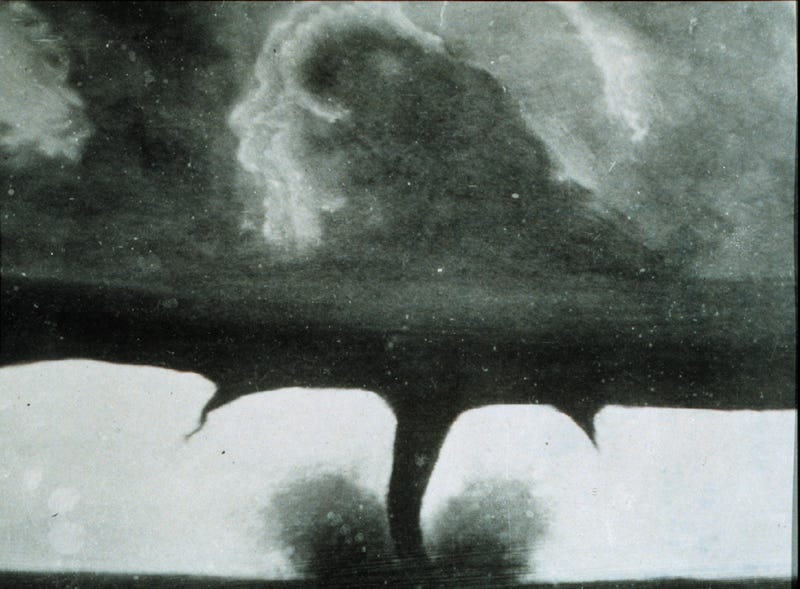
Figure 126. Twin tornadoes that did F4 damage in Dunlap, IN, 1965-04-11, courtesy Paul Huffman.
Multiple concurrent vor
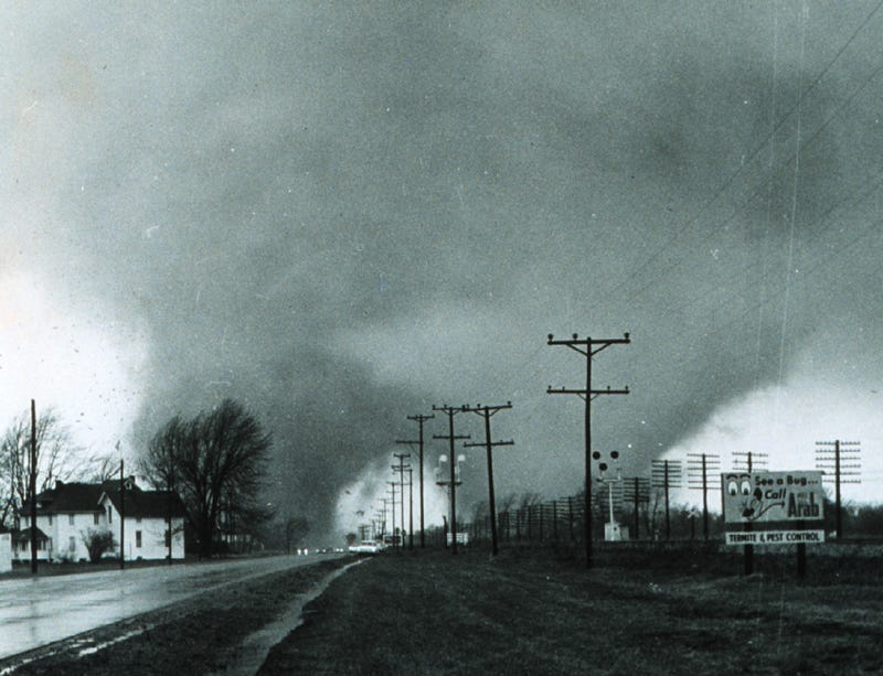
texes are not terribly unusual in fluid dynamics. But multiple, extremely powerful, steady-state vortexes, close to each other, are somewhat more difficult to understand. If nature hates a vacuum, then nature really hates two of them close together that refuse to merge into a unified low pressure system. The pressure gradients around vortexes radiate in all directions, and between two vortexes, the pressure will be twice as low. This will pull the vortexes together, and they will merge. (This is known as the "Fujiwhara effect.") So the twin tornado configuration is the toughest to understand.
It might be significant to note that the rare steady-state twin tornadoes have all been F4s. As bottleneck vortexes, each F4 tornado is expending billions of watts fighting skin friction on the ground. Since skin friction varies with the square of the velocity, combining both F4 tornadoes into one (F?) tornado would have required far more power to move the same amount of air. So there might be a threshold above which the bottleneck vortex is more stable in the twin configuration, and there might never be an F6 tornado — anything above an F5 will split into two F4s.
A study of the damage paths of extremely powerful tornadoes reveals that the damage is not distributed evenly within the tornado, but rather, is focused in a far smaller area, sometimes in the center of the tornado, and sometimes in a path that meanders within the width of the funnel cloud.193,194 In other words, an F5 tornado might be over 2 km wide, but the extent of the F5 damage might be less than 500 m wide. (See Figure 45 for an example.) Figure 127 shows a similar pattern. (Note that in the center of the damage path, there wasn't anything left by which the wind speeds could be gauged — the engineers could only guess that the winds had to be in the EF 4~6 range to cause such complete destruction.)
.jpg)
Figure 127. Damage path in Greensburg, KS, 2007-05-04, courtesy FEMA.

Doppler radar studies have clearly shown that tornadoes can have eccentric sub-vortexes.152 (See Figure 128.) Some researchers believe that the most extreme damage is done by the sub-vortexes. This would explain why a tornado might totally destroy one house, and spare the house next to it, even though both houses were definitely fully inside the same funnel cloud.
Figure 128. Inner vortexes, 1999-05-03, courtesy Joshua Wurman.
(P = reflectivity, V = velocity.)

If the sub-vortex is more powerful than the main vortex, then we have a non-continuous pressure gradient inside another pressure gradient, which doesn't make sense. This constitutes rigorous proof that there are two sets of factors producing these vortexes. So what are they?
We already have the answer, because we have already identified two different flow fields under a supercell, caused by two different sets of factors. There is a flow field associated with the mesocyclone, and there is a separate flow field associated with the tornado. And the tornado occurs inside the context of the mesocyclone's flow field. It's possible that the main vortex is the inflow to the mesocyclone, which has descended and grown so powerful that it becomes airlocked at the lower boundary. The large volume of air flowing into the mesocyclone, at a slower rate, results in an extremely wide vortex (over 2 km), but relatively weak winds (EF2 or below).
Yet before the mesocyclone "descended," the tornado (to become the sub-vortex) was already established. The extreme low pressure inside that vortex makes it the best conduit for the flow of electrons down from the cloud, and this conduit persists. The reason is that it is maintained by mutually-enhancing factors. The lower the pressure, the greater the electric current, and the more current, the more buoyant the air, which further decreases the pressure. When the mesocyclone "descends" and latches onto the ground, the air supply to the sub-vortex is restricted. This further decreases the pressure inside the sub-vortex, making it an even better conduit, resulting in more complete charge neutralization, and the most extreme energy release possible inside the sub-vortex.
So the air flows in from all around. Any air that isn't charged, or is weakly charged, can flow up into the (mesocyclonic) outer vortex. The more highly charged air still refuses to break away from the ground, and flows into the sub-vortex, where it gets neutralized and sucked up into the sub-vortex. Air that finally gets into the sub-vortex was pre-heated as it flowed toward the main vortex, re-heated as it slid under the main vortex wall, and heated some more on its way into the sub-vortex. Complete charge neutralization inside the sub-vortex then results in an instantaneous release of all of that thermal energy.
Somewhere in the range of 85%~95% of all cloud-to-ground lightning is "negative," wherein the discharge is between a negative pole in the cloud and a positive pole in the ground.195 This is easy to understand, since the main negative charge region is lower in the cloud (and therefore closer to the ground) than the main positive region, hence an arc discharge can occur with less voltage, so it happens more frequently. Lightning from the main positive charge region at the top of the cloud down to the ground requires upward of 100 million volts to initiate an arc discharge, so it is a bit more rare.
This does not mean that all positive strikes have to come from the upper portion of the cloud. Weaker positive charge regions can develop lower in the cloud, resulting in positive strikes with less voltage. But usually, the lower positive regions are too weak to initiate lightning, and negative strikes dominate the statistics.
The interesting thing about supercells is that they develop as "normal" thunderstorms, with a negative charge in the middle of the cloud inducing a positive charge in the Earth. Then typically there is a polarity reversal as the storm enters the tornadic phase, and the charge aloft becomes positive, with an induced negative charge in the Earth. The CG lightning issued during this phase is predominantly (or even exclusively) positive.133,196,197 Shortly after the tornado ropes out, the polarity reverses again, back to the "normal" configuration.
This is anomalous because we can clearly see the internal structure of the storm on Doppler radar, and there is no change in storm structure that accompanies these polarity reversals. This might sound trivial, but it is not. While protons and electrons have exactly the same amount of charge (though opposite in sign), they have very different physical characteristics. In a thunderstorm, negative charges are found mostly in hail and to a lesser extent in large raindrops, while positive charges are carried by microscopic ice crystals, supercooled aerosols, and by nitrogen and oxygen molecules that collide with positively charged water molecules. Since hail is the best radar reflector in the storm, with large raindrops being good reflectors, and since these are the primary negative charge carriers, we should expect the negative charge regions to correspond roughly to what we see on radar.133,134,135 The significance of this is that a polarity reversal should be accompanied by a visible change in the storm structure on radar, but it is not.
In the standard model, this is not a solvable problem, because all of the electric charges are assumed to be in the cloud, carried by water molecules. No existing construct asserts that the air between the cloud and the ground might be bearing a powerful electric charge. Hence the polarity reversal, without a corresponding change in Doppler radar, is inexplicable.
The more reasonable interpretation is that if the radar data are telling us that the main negative charge region is still there, its charge is still there too. If the perceived electric field at the surface inverts, then a positive double-layer has come between us and the negative charge region. Hence the combination of the radar and electric field data constitute one of the proofs that during the tornadic phase, the air below the cloud is bearing a strong positive charge. When this double-layer dissipates, the tornado ropes out, and the polarity returns to normal (showing a negative charge aloft).